American network of Earth-observing satellites for international research purposes
Landsat 7, launched in 1999, is the 7th of 9 satellites in the Landsat program.
A false-color satellite image of Kolkata, India, from Landsat 7 in 2004, showing rivers, vegetated areas, and developed areas
A land cover map of the big island of Hawaii using 1999–2001 data from Landsat 7, showing black lava flows from Mauna Loa, grayish dormant Mauna Kea, a plume of smoke from active Kilauea, dark green tropical forests, and light green agricultural areas.
The Landsat program is the longest-running enterprise for acquisition of satellite imagery of Earth. It is a joint NASA / USGS program. On 23 July 1972, the Earth Resources Technology Satellite was launched. This was eventually renamed to Landsat 1 in 1975.[1] The most recent, Landsat 9, was launched on 27 September 2021.
The instruments on the Landsat satellites have acquired millions of images. The images, archived in the United States and at Landsat receiving stations around the world, are a unique resource for global change research and applications in agriculture, cartography, geology, forestry, regional planning, surveillance and education, and can be viewed through the U.S. Geological Survey (USGS) "EarthExplorer" website. Landsat 7 data has eight spectral bands with spatial resolutions ranging from 15 to 60 m (49 to 197 ft); the temporal resolution is 16 days.[2] Landsat images are usually divided into scenes for easy downloading. Each Landsat scene is about 115 miles long and 115 miles wide (or 100 nautical miles long and 100 nautical miles wide, or 185 kilometers long and 185 kilometers wide).
^Short, N.M. (1982). The LANDSAT Tutorial Workbook: Basics of Satellite Remote Sensing. Washington DC: NASA. hdl:2060/19830002188. 1078. This article incorporates text from this source, which is in the public domain.
^The Landsat Program – Technical Details Archived 2010-05-01 at the Wayback Machine This article incorporates text from this source, which is in the public domain.
The Landsatprogram is the longest-running enterprise for acquisition of satellite imagery of Earth. It is a joint NASA / USGS program. On 23 July 1972...
Landsat 7 is the seventh satellite of the Landsatprogram. Launched on 15 April 1999, Landsat 7's primary goal is to refresh the global archive of satellite...
distributes the data archive. It is the ninth satellite in the Landsatprogram, but Landsat 6 failed to reach orbit. The Critical Design Review (CDR) was...
Landsat 8 is an American Earth observation satellite launched on 11 February 2013. It is the eighth satellite in the Landsatprogram; the seventh to reach...
Landsat 1 (LS-1), formerly named ERTS-A and ERTS-1, was the first satellite of the United States' Landsatprogram. It was a modified version of the Nimbus...
Landsat 4 is the fourth satellite of the Landsatprogram. It was launched on July 16, 1982, with the primary goal of providing a global archive of satellite...
Landsat 6, equipped with upgraded versions of the instruments on Landsat 5, was designed to carry forward the Landsatprogram. It was launched on October...
collect imagery of the surface of Earth. A continuation of the Landsat Program, Landsat 5 was jointly managed by the U.S. Geological Survey (USGS) and the...
Landsat 3 is the third satellite of the Landsatprogram. It was launched on March 5, 1978, with the primary goal of providing a global archive of satellite...
years immediately following the mission. In the early 1980s, NASA's Landsatprogram was facing a severe data tape shortage and it is likely the tapes were...
November 2004, operational LandsatprogramLandsat 1, launched July 1972, completed Landsat 2, launched January 1975, completed Landsat 3, launched March 1978...
formats that image processing systems used in the early years of NASA's Landsatprogram. Thomas was born in Baltimore, Maryland. She graduated from high school...
among the public. Also in 1972 the United States started the Landsatprogram, the largest program for acquisition of imagery of Earth from space. In 1977,...
Landsat 2 is the second satellite of the Landsatprogram. The spacecraft originally carried a designation of ERTS-B (Earth Resource Technology Satellite...
As of 2022, there have been nine LandSat satellites with LandSat 7, 8, and 9 orbiting the Earth. The LandSatprogram has involved many organisations since...
to the Landsatprogram, having designed the Multispectral Scanner which was first used on Landsat 1. She has been called "The Mother of Landsat" for this...
observing sensors introduced in the Landsatprogram. A Multispectral Scanner was placed aboard each of the first five Landsat satellites. The scanner was designed...
Command. The Landsatprogram is the longest-running enterprise for acquisition of satellite imagery of Earth. It is a joint NASA / USGS program. On July 23...
Landsat Island is a small, uninhabited island located at approximately 60°10'37"N 64°02'30"W, 20 kilometres (12 mi) off the northeast coast of Labrador...
Earth Observations Global Earth Observation System of Systems Phi Lab Landsatprogram TerraSAR-X: a German Earth observation satellite Radiant Earth Foundation:...
Thematic Mapper, one of the Earth observing sensors introduced in the Landsatprogram Wisconsin H-Alpha Mapper, a custom-built 0.6 metres (24 in) telescope...
Landsatprogram, Canada's RADARSAT-1 and an entire list of Earth observation satellites. In August 1998, NASA contracted EarthSat to produce Landsat GeoCover...
Administration operates various services with space components, such as the Landsatprogram. Military space activities are implemented by the United States Space...
observation satellites (e.g. Landsatprogram, 1972), space telescopes and particularly space stations (e.g. Salyut program, 1971). The until 1979 negotiated...
found on Earth observation satellites, including (for example) the Landsatprogram or the IKONOS satellite. Maps of land cover and land use from thematic...
data is also available from Ikonos and QuickBird. LANDSATprogram (8 satellites, 3 active). GOSAT program (2 satellites, 2 active). Radarsat-2 satellite...
Resources Technology Satellite (ERTS), which became the precursor to the Landsatprogram. These early sensors had minimal spectral resolution, but tended to...
engineers and program specialists in one of the Agency's most ambitious projects to determine if life ever existed on Mars. The programs long range objective...
 Global Information
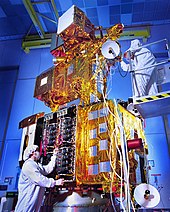


 This article incorporates text from this source, which is in the public domain.