Acquisition of information at a significant distance from the subject
Not to be confused with remote viewing.
For other uses, see Remote sensing (disambiguation).
This article needs additional citations for verification. Please help improve this article by adding citations to reliable sources. Unsourced material may be challenged and removed. Find sources: "Remote sensing" – news · newspapers · books · scholar · JSTOR(September 2023) (Learn how and when to remove this message)
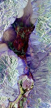
Synthetic aperture radar image of Death Valley colored using polarimetry
Remote sensing is the acquisition of information about an object or phenomenon without making physical contact with the object, in contrast to in situ or on-site observation. The term is applied especially to acquiring information about Earth and other planets. Remote sensing is used in numerous fields, including geophysics, geography, land surveying and most Earth science disciplines (e.g. exploration geophysics, hydrology, ecology, meteorology, oceanography, glaciology, geology). It also has military, intelligence, commercial, economic, planning, and humanitarian applications, among others.
In current usage, the term remote sensing generally refers to the use of satellite- or aircraft-based sensor technologies to detect and classify objects on Earth. It includes the surface and the atmosphere and oceans, based on propagated signals (e.g. electromagnetic radiation). It may be split into "active" remote sensing (when a signal is emitted by a satellite or aircraft to the object and its reflection is detected by the sensor) and "passive" remote sensing (when the reflection of sunlight is detected by the sensor).[1][2][3][4]
^Schowengerdt, Robert A. (2007). Remote sensing: models and methods for image processing (3rd ed.). Academic Press. p. 2. ISBN 978-0-12-369407-2. Archived from the original on 1 May 2016. Retrieved 15 November 2015.
^Schott, John Robert (2007). Remote sensing: the image chain approach (2nd ed.). Oxford University Press. p. 1. ISBN 978-0-19-517817-3. Archived from the original on 24 April 2016. Retrieved 15 November 2015.
^Guo, Huadong; Huang, Qingni; Li, Xinwu; Sun, Zhongchang; Zhang, Ying (2013). "Spatiotemporal analysis of urban environment based on the vegetation–impervious surface–soil model" (PDF). Journal of Applied Remote Sensing. 8: 084597. Bibcode:2014JARS....8.4597G. doi:10.1117/1.JRS.8.084597. S2CID 28430037. Archived (PDF) from the original on 19 July 2018. Retrieved 27 October 2021.
^Liu, Jian Guo & Mason, Philippa J. (2009). Essential Image Processing for GIS and Remote Sensing. Wiley-Blackwell. p. 4. ISBN 978-0-470-51032-2. Retrieved 2 April 2023.
Remotesensing is the acquisition of information about an object or phenomenon without making physical contact with the object, in contrast to in situ...
Remotesensing techniques in archaeology are an increasingly important component of the technical and methodological tool set available in archaeological...
Remotesensing is used in the geological sciences as a data acquisition method complementary to field observation, because it allows mapping of geological...
India's remotesensing program was developed with the idea of applying space technologies for the benefit of humankind and the development of the country...
A remotesensing software is a software application that processes remotesensing data. Remotesensing applications are similar to graphics software, but...
The Pakistan RemoteSensing Satellite (PRSS), is an earth observation optical satellite launched from China's Jiuquan Satellite Centre on 9 July 2018....
National RemoteSensing Centre (Hindi: राष्ट्रीय सुदूर संवेदन केन्द्र), or NRSC, located in Hyderabad, Telangana is one of the centres of the Indian Space...
The Indian Institute of RemoteSensing is an institute for research, higher education and training in the field of remotesensing, geoinformatics and GPS...
The Bangladesh Space Research and RemoteSensing Organization (Bengali: বাংলাদেশ মহাকাশ গবেষণা ও দূর অনুধাবন প্রতিষ্ঠান, romanized: Bangladesh mohakash...
Radar remotesensing is a type of active remoteSensing which uses electromagnetic energy backscattered from ground targets to extract physical and dielectric...
to the NASA ARES YouTube page. The Earth Science and RemoteSensing Unit (ESRS) is a remotesensing ground unit of NASA. It is part of NASA's Astromaterials...
director of the United States Geological Survey, proposed the idea of a remotesensing satellite program to gather facts about the natural resources of our...
six remotesensing satellites expected to be developed and launched under this programme. Suparco is intending to launch its first remotesensing satellite...
Giovanni Domenico Cassini, the great Italian astronomer. Even though remotesensing has greatly sped up the process of gathering information, and has allowed...
Thermal remotesensing is a branch of remotesensing in the thermal infrared region of the electromagnetic spectrum. Thermal radiation from ground objects...
RemoteSensing Systems (RSS) is a private research company founded in 1974 by Frank Wentz. It processes microwave data from a variety of NASA satellites...
reflected. Satellite imagery is an example of passive remotesensing. Here are two active remotesensing instruments: Lidar: Lidar (light detection and ranging)...
Authority for RemoteSensing and Space Sciences (NARSS) is the pioneering Egyptian institution in the field of satellite remotesensing and space sciences...
An Earth observation satellite or Earth remotesensing satellite is a satellite used or designed for Earth observation (EO) from orbit, including spy satellites...
Society Engineering in Medicine and Biology Society Geoscience and RemoteSensing Society Industrial Electronics Society Industry Applications Society...
for space exploration. ISRO has the world's largest constellation of remote-sensing satellites and operates the GAGAN and IRNSS (NavIC) satellite navigation...
General Organization of RemoteSensing (Arabic: الهيئة العامة للإستشعار عن بعد), (GORS) is a Syrian space research agency established in 1986. Headquartered...
truth data enables calibration of remote-sensing data, and aids in the interpretation and analysis of what is being sensed. Examples include cartography,...
taking mixed-methods approaches. Common techniques include cartography, remotesensing, interviews, and surveying. Geography is a systematic study of the Earth...
Furthermore, remote sensing is the best and perhaps only possible way to study the Amazon on a large scale. The use of remotesensing for the conservation...
time scale. These changes increased political interest in gathering remote-sensing data on the Earth itself and stimulated the science of climatology....
 Global Information