American Earth-observing satellite launched in 1982 as part of the Landsat program
Landsat 4
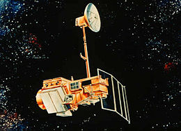
Artist's rendering of Landsat 5, which is identical to Landsat 4.
Mission type
Earth imaging
Operator
NASA / NOAA
COSPAR ID
1982-072A
SATCAT no.
13367
Spacecraft properties
Bus
Multimission Modular Spacecraft
Manufacturer
GE Astro Space
Launch mass
1,941 kilograms (4,279 lb)
Dry mass
1,407 kilograms (3,102 lb)
Start of mission
Launch date
July 16, 1982 (1982-07-16)
Rocket
Delta 3920
Launch site
Vandenberg AFB SLC-2W
End of mission
Deactivated
June 15, 2001 (2001-06-16)
Orbital parameters
Reference system
Geocentric
Regime
Sun-synchronous
Perigee altitude
700 kilometers (430 mi)
Apogee altitude
704 kilometers (437 mi)
Inclination
98.2 degrees
Period
98.81 minutes
Repeat interval
16 days
Epoch
August 17, 1982[1]
Landsat 4 is the fourth satellite of the Landsat program. It was launched on July 16, 1982, with the primary goal of providing a global archive of satellite imagery. Although the Landsat Program is managed by NASA, data from Landsat 4 was collected and distributed by the U.S. Geological Survey. Landsat 4 science operations ended on December 14, 1993, when the satellite lost its ability to transmit science data, far beyond its designed life expectancy of five years. The satellite housekeeping telemetry and tracking continued to be maintained by NASA until it was decommissioned on June 15, 2001.
^McDowell, Jonathan. "Satellite Catalog". Jonathan's Space Page. Retrieved June 16, 2013.
Landsat4 is the fourth satellite of the Landsat program. It was launched on July 16, 1982, with the primary goal of providing a global archive of satellite...
eventually renamed to Landsat 1 in 1975. The most recent, Landsat 9, was launched on 27 September 2021. The instruments on the Landsat satellites have acquired...
Landsat 9 is an Earth observation satellite launched on 27 September 2021 from Space Launch Complex-3E at Vandenberg Space Force Base on an Atlas V 401...
Landsat 7 is the seventh satellite of the Landsat program. Launched on 15 April 1999, Landsat 7's primary goal is to refresh the global archive of satellite...
Landsat 8 is an American Earth observation satellite launched on 11 February 2013. It is the eighth satellite in the Landsat program; the seventh to reach...
Landsat 5 was a low Earth orbit satellite launched on March 1, 1984, to collect imagery of the surface of Earth. A continuation of the Landsat Program...
Landsat 1 (LS-1), formerly named ERTS-A and ERTS-1, was the first satellite of the United States' Landsat program. It was a modified version of the Nimbus...
about 4.6 terabytes. Scientific Visualization Studio MODIS GLOBE NRL Real-Time Weather Blue Marble Next Generation imagery Landsat 7 imagery NLT Landsat (Visible...
Landsat 3 is the third satellite of the Landsat program. It was launched on March 5, 1978, with the primary goal of providing a global archive of satellite...
1991 Landsat 5 for NASA/USGS- launched in 1984 (the satellite holds Guinness World Record for longest operating earth observing satellite) Landsat4 for...
to the Landsat program, having designed the Multispectral Scanner which was first used on Landsat 1. She has been called "The Mother of Landsat" for this...
The Thematic Mapper (TM) sensor on Landsat4 and Landsat 5 included a thermal (6th) band. Landsat 8 and Landsat-9 also acquires thermal data in two 10...
manufactured by Fairchild Industries, a platform which was later used for Landsats4 and 5 as well as the Upper Atmosphere Research Satellite. After an attitude...
Landsat 2 is the second satellite of the Landsat program. The spacecraft originally carried a designation of ERTS-B (Earth Resource Technology Satellite...
introduced in the Landsat program. The first was placed aboard Landsat4 (decommissioned in 2001), and another was operational aboard Landsat 5 up to 2012...
Landsat Island is a small, uninhabited island located at approximately 60°10'37"N 64°02'30"W, 20 kilometres (12 mi) off the northeast coast of Labrador...
media and among the public. Also in 1972 the United States started the Landsat program, the largest program for acquisition of imagery of Earth from space...
commercially available Earth-observation satellites including Landsat4, Landsat 5, Landsat 7, IKONOS, IRS, ERS, QuickBird, and ENVISAT. In 1999, MDA completed...
Space Launch Complex 4 (SLC-4) is a launch and landing site at Vandenberg Space Force Base, California, U.S. It has two pads, both of which are used by...
weighted sum of the Landsat bands (without the thermal channel 6), where each band is multiplied by the specific coefficients. Early Landsat products: Brightness...
NOAA-4, Intasat, and AMSAT-OSCAR 7 on 15 November 1974.[citation needed] Delta 2910 boosters were used to launch both Landsat 2 in 1975 and Landsat 3 in...
imaging data was provided by the United States Geological Survey's Landsat4 and Landsat 5 spacecraft, as well as the French CNES SPOT satellites. Coalition...
Before the launch of NASA and the USGS's Landsat 8 satellite, Google relied partially on imagery from Landsat 7, which suffered from a hardware malfunction...
remote sensing instrument aboard Landsat 8, built by Ball Aerospace & Technologies. Landsat 8 is the successor to Landsat 7 and was launched on February...
renamed to Landsat 1 in 1975. The most recent satellite in the series, Landsat 9, was launched on September 27, 2021. The instruments on the Landsat satellites...
 Global Information