American Earth-observing satellite launched in 2013 as part of the Landsat program
Landsat 8
Landsat 8 during ground testing
Names
Landsat Data Continuity Mission
Mission type
Satellite imagery
Operator
NASA / USGS
COSPAR ID
2013-008A
SATCAT no.
39084
Website
[1]
Mission duration
5 years (planned) 10 years (with fuel) Elapsed: 11 years, 3 months, 12 days
Spacecraft properties
Spacecraft
Landsat 8
Spacecraft type
LEOStar
Bus
LEOStar-3
Manufacturer
Orbital Sciences (prime) Ball Aerospace (OLI) NASA GSFC (TIRS)
Launch mass
2,623 kg (5,783 lb)
Dry mass
1,512 kg (3,333 lb)
Start of mission
Launch date
11 February 2013, 18:02:00 UTC
Rocket
Atlas V 401 (AV-035)
Launch site
Vandenberg, SLC-3E
Contractor
United Launch Alliance
Entered service
30 May 2013
Orbital parameters
Reference system
Geocentric orbit[1]
Regime
Sun-synchronous orbit
Altitude
705 km
Inclination
98.22°
Period
98.8 minutes
Instruments
Operational Land Imager (OLI) Thermal Infrared Sensor (TIRS)
Landsat Data Continuity Mission (LDCM) mission patch
Landsat program
← Landsat 7
Landsat 9 →
Landsat 8 is an American Earth observation satellite launched on 11 February 2013. It is the eighth satellite in the Landsat program; the seventh to reach orbit successfully. Originally called the Landsat Data Continuity Mission (LDCM), it is a collaboration between NASA and the United States Geological Survey (USGS). NASA Goddard Space Flight Center in Greenbelt, Maryland, provided development, mission systems engineering, and acquisition of the launch vehicle while the USGS provided for development of the ground systems and will conduct on-going mission operations. It comprises the camera of the Operational Land Imager (OLI) and the Thermal Infrared Sensor (TIRS), which can be used to study Earth surface temperature and is used to study global warming.[2]
The satellite was built by Orbital Sciences Corporation, who served as prime contractor for the mission.[3] The spacecraft's instruments were constructed by Ball Aerospace & Technologies and NASA's Goddard Space Flight Center (GSFC),[4] and its launch was contracted to United Launch Alliance (ULA).[5] During the first 108 days in orbit, LDCM underwent checkout and verification by NASA and on 30 May 2013 operations were transferred from NASA to the USGS when LDCM was officially renamed to Landsat 8.[6]
^"Landsat 8 Orbit". Heavens Above. 28 May 2016. Retrieved 28 May 2016.
^Li, Rita Yi Man; Chau, Kwong Wing; Li, Herru Ching Yu; Zeng, Fanjie; Tang, Beiqi; Ding, Meilin (2021). Ahram, Tareq (ed.). "Remote Sensing, Heat Island Effect and Housing Price Prediction via AutoML". Advances in Artificial Intelligence, Software and Systems Engineering. Advances in Intelligent Systems and Computing. Cham: Springer International Publishing: 113–118. doi:10.1007/978-3-030-51328-3_17. ISBN 978-3-030-51328-3.
^"Fact Sheet - LDCM Earth Image Collection Satellite" (PDF). Orbital Sciences Corporation. Retrieved 12 February 2013.
^"LDCM Spacecraft". NASA. Retrieved 12 February 2013. This article incorporates text from this source, which is in the public domain.
^"United Launch Alliance Successfully Launches Second NASA Payload in Just 12 Days". United Launch Alliance. 11 February 2013. Archived from the original on 7 December 2013. Retrieved 12 February 2013.
^"Landsat 8 Satellite Begins Watch". NASA. 30 May 2013. This article incorporates text from this source, which is in the public domain.
Landsat8 is an American Earth observation satellite launched on 11 February 2013. It is the eighth satellite in the Landsat program; the seventh to reach...
eventually renamed to Landsat 1 in 1975. The most recent, Landsat 9, was launched on 27 September 2021. The instruments on the Landsat satellites have acquired...
Landsat 9 is an Earth observation satellite launched on 27 September 2021 from Space Launch Complex-3E at Vandenberg Space Force Base on an Atlas V 401...
Landsat 7 is the seventh satellite of the Landsat program. Launched on 15 April 1999, Landsat 7's primary goal is to refresh the global archive of satellite...
remote sensing instrument aboard Landsat8, built by Ball Aerospace & Technologies. Landsat8 is the successor to Landsat 7 and was launched on February...
Landsat 5 was a low Earth orbit satellite launched on March 1, 1984, to collect imagery of the surface of Earth. A continuation of the Landsat Program...
Landsat 5, thermal infrared imagery was also collected (at coarser spatial resolution than the optical data). The Landsat 7, Landsat8, and Landsat 9...
The Thematic Mapper (TM) sensor on Landsat 4 and Landsat 5 included a thermal (6th) band. Landsat8 and Landsat-9 also acquires thermal data in two 10...
weighted sum of the Landsat bands (without the thermal channel 6), where each band is multiplied by the specific coefficients. Early Landsat products: Brightness...
of scan swath. All sensors aboard the Landsat series of satellites used the whisk broom design until Landsat8 which used a push broom sensor. Push broom...
companies. As of 2022, there have been nine LandSat satellites with LandSat 7, 8, and 9 orbiting the Earth. The LandSat program has involved many organisations...
August 2010, and the temperature was deduced from radiance measured by the Landsat8 and other satellites. It was discovered during a National Snow and Ice...
Landsat 4 is the fourth satellite of the Landsat program. It was launched on July 16, 1982, with the primary goal of providing a global archive of satellite...
November 2004, operational Landsat program Landsat 1, launched July 1972, completed Landsat 2, launched January 1975, completed Landsat 3, launched March 1978...
in 2006 From the International Space Station on February 7, 2022 With Landsat8 on March 20, 2022 Center for Menominee Language, Culture, and Art, Language...
Synop Report Summary". Ogimet.com. Retrieved 5 August 2019. "NASA-USGS Landsat8 Satellite Pinpoints Coldest Spots on Earth". Archived from the original...
Landsat 1 (LS-1), formerly named ERTS-A and ERTS-1, was the first satellite of the United States' Landsat program. It was a modified version of the Nimbus...
News, 9 December 2013. The Coldest Place on Earth: -90 °C and below from Landsat8 and other satellite thermal sensors Archived 3 March 2016 at the Wayback...
µm) or long-wave infrared (LWIR; 8 to 12 µm) bands into a single system. — Valerie C. Coffey In the case of Landsat satellites, several different band...
volume. Earth observation data cubes combine satellite imagery such as Landsat8 and Sentinel-2 with Geographic information system analytics. In online...
these tools reduce field visits and enable better irrigation management. Landsat8, Sentinel-2 and PlanetScope are some of the main providers of satellite...
(2018). "Detection of Pb–Zn mineralization zones in west Kunlun using Landsat8 and ASTER remote sensing data". Journal of Applied Remote Sensing. 12...
Before the launch of NASA and the USGS's Landsat8 satellite, Google relied partially on imagery from Landsat 7, which suffered from a hardware malfunction...
 Global Information
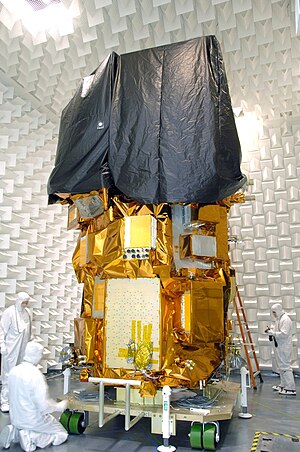
 This article incorporates text from this source, which is in the public domain.