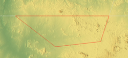
Bir Tawil (Egyptian Arabic: بير طويل, romanized: Bīr Ṭawīl, lit. 'tall water well', [biːɾtˤɑˈwiːl]) is a 2,060 km2 (795.4 sq mi) area of land along the border between Egypt and Sudan, which is uninhabited and claimed by neither country. When spoken of in association with the neighbouring Halaib Triangle, it is sometimes referred to as the Bir Tawil Triangle, despite the area's quadrilateral shape; the two regions border at a quadripoint.
Its unclaimed status results from a discrepancy between the straight political boundary between Egypt and Sudan established in 1899, and the irregular administrative boundary established in 1902. Egypt asserts the political boundary, and Sudan asserts the administrative boundary, with the result that the Halaib Triangle is claimed by both and Bir Tawil by neither. In 2014, author Alastair Bonnett described Bir Tawil as the only place on Earth that was habitable but was not claimed by any recognised government.[2]
^Karalekas, Dean (2020). "Navigating Terra Nullius: The Ababda and the Case for Indigenous Land Rights in Bir Tawil" (PDF). Global Journal of Economics and Finance. 4 (2): 41–49.
^Bonnett, Alastair (2014). "Bir Tawil". Unruly Places: Lost Spaces, Secret Cities and Other Inscrutable Geographies. Houghton Mifflin Harcourt. p. 73. ISBN 978-0-544-10160-9. LCCN 2013050983. OCLC 890509603. the only place on the planet that is both habitable and unclaimed.
BirTawil (Egyptian Arabic: بير طويل, romanized: BīrṬawīl, lit. 'tall water well', [biːɾ tˤɑˈwiːl]) is a 2,060 km2 (795.4 sq mi) area of land along the...
are currently three territories sometimes claimed to be terra nullius: BirTawil (a strip of land between Egypt and the Sudan), four pockets of land near...
referred to as BirTawil, joins the Halaib Triangle at its westernmost point along the latitude line – neither Sudan nor Egypt claims BirTawil. Beja, Arabic...
currently controlled by Egypt. The area (along with the Halaib Triangle and BirTawil) is created by two different definitions of the Egypt–Sudan border: the...
the Tiris Zemmour region of Mauritania Bir Salim, a Palestinian Arab village in the Ramle Subdistrict BirTawil, a small area along the border between...
uninhabitable tracts of land. For instance, some micronations have claimed BirTawil in Africa and Marie Byrd Land in West Antarctica, lands which are terra...
الـزَّرْقَـاء, romanized: Jabal Ḥajar az-Zarqā’) is the highest point in BirTawil, an unclaimed area in the Nubian desert between Egypt and Sudan in Northeast...
resulting in the Halaib Triangle being claimed by both countries and BirTawil being unclaimed by any UN member state. At this latitude the sun is visible...
v t e Micronations List of micronations Africa BirTawil Empire Kalakuta Republic M'Simbati North Sudan Reunion Yellow Mountain North America Conch Republic...
v t e Micronations List of micronations Africa BirTawil Empire Kalakuta Republic M'Simbati North Sudan Reunion Yellow Mountain North America Conch Republic...
including islands, Mukawwa Island ** Egypt's southernmost point lies in the BirTawil region, an area that is commonly included as part of Egypt but is not...
structures in Hong Kong List of urban public parks and gardens in Hong Kong BirTawil Centro Financiero Confinanzas, an abandoned skyscraper populated in a...
square miles (2,100 km2) - for reference, the unclaimed territory of BirTawil has an area of 795 square miles. There is at least one reference in the...
of Matthew Town, Great Inagua Island 20°55′N Egypt Jebel Bartazuga, BirTawil (disputed) border with Sudan 21°44′N 22°00′N Hong Kong Tau Lo Chau, Soko...
between Sudan and Egypt. It is currently under Egyptian administration. BirTawil is a terra nullius occurring on the border between Egypt and Sudan, claimed...
v t e Micronations List of micronations Africa BirTawil Empire Kalakuta Republic M'Simbati North Sudan Reunion Yellow Mountain North America Conch Republic...
Gangkhar Puensum 7570 m 24,836 ft Drangme Chhu 97 m 318 ft 7473 m 24,518 ft BirTawil Gabal Hagar El Zarqa 662 m 2,172 ft [data missing] Bolivia Sajama 6542 m...
Araucanía and Patagonia Asgardia Empire of Atlantium Empire of Austenasia BirTawil Empire Province of Bumbunga Christiania Conch Republic Elgaland-Vargaland...
Jacobs, Franks (23 July 2010). "396 - "You take it - No, you take it": the BirTawil Trapezoid". Big Think. Retrieved 3 June 2021. "Libya", The World Factbook...
autonomous region) (with multicolored coat of arms) Białobrzegi, Poland BirTawil Bosnia and Herzegovina Brisbane, Queensland, Australia Buryatia, Russia...
remote area of the Nubian Desert involving both the Hala'ib Triangle and BirTawil (about midway between the River Nile and the Red Sea) where the long established...
to claim the land and each country says it belongs to the other. (See BirTawil for a similar real-life example of this.) Bullwinkle J. Moose serves as...
 Global Information