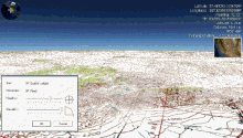
Screenshot of WorldWind showing Blue Marble Next Generation layer
Developer(s)
Ames Research Center (NASA)
Initial release
2003
Repository
github.com/NASAWorldWind/
Written in
JavaScript (Web), Java (Android, Desktop Java SE, and Server), C# (obsolete Windows/.NET)
Operating system
Cross-platform; see above
Available in
English
Type
Virtual globe software development kit
License
NASA Open Source Agreement v1.3
Website
worldwind.arc.nasa.gov
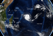
Animation showing atmosphere and shading effects in v1.4USGS Urban Ortho-Imagery of Huntington Beach, California in older version of WorldWind (1.2)Rapid Fire MODIS – Hurricane KatrinaA cyclone moving across the Indian Ocean (on normal cloud cover – not Rapid Fire MODIS)Moon – Hypsometric Map layerMars (THEMIS layer) – Olympus MonsHurricane Dean in NASA WorldWindWashington DC, Wikipedia point layer – icons link to Wikipedia articles
NASA WorldWind is an open-source (released under the NOSA license and the Apache 2.0 license) virtual globe. According to the website (https://worldwind.arc.nasa.gov/), "WorldWind is an open source virtual globe API. WorldWind allows developers to quickly and easily create interactive visualizations of 3D globe, map and geographical information. Organizations around the world use WorldWind to monitor weather patterns, visualize cities and terrain, track vehicle movement, analyze geospatial data and educate humanity about the Earth." It was first developed by NASA in 2003 for use on personal computers and then further developed in concert with the open source community since 2004. As of 2017,[update] a web-based version of WorldWind is available online.[1] An Android version is also available.[2]
The original version relied on .NET Framework, which ran only on Microsoft Windows. The more recent Java version, WorldWind Java, is cross platform, a software development kit (SDK) aimed at developers and, unlike the old .NET version, not a standalone virtual globe application in the style of Google Earth. The WorldWind Java version was awarded NASA Software of the Year in November 2009.[3] The program overlays NASA and USGS satellite imagery, aerial photography, topographic maps, Keyhole Markup Language (KML) and Collada files.
^"World Wind Explorer". explorer.worldwind.earth.
^"WorldWindAndroid github repository". GitHub. 15 May 2020.
^"Software of the Year Award, WorldWind Java". nasa.gov. December 24, 2009. Archived from the original on June 11, 2013.
According to the website (https://worldwind.arc.nasa.gov/), "WorldWind is an open source virtual globe API. WorldWind allows developers to quickly and...
Globe 98, followed by Cosmi's 3D World Atlas in 1999. The first widely publicized online virtual globes were NASAWorldWind (released in mid-2004) and Google...
and data from Landsat 7 is collected and distributed by the USGS. The NASAWorldWind project allows 3D images from Landsat 7 and other sources to be freely...
1975, NASA managed a program for the United States Department of Energy and the United States Department of Interior to develop utility-scale wind turbines...
nearly devoid of vegetation. A superimposition of the map with current NASAWorldWind satellite images shows the extent of flooding in the area of the salient...
created in 2010 by the Air Force Research Laboratory, and based on the NASAWorldWind Mobile codebase its development and deployment grew slowly, then rapidly...
content management system GPS eXchange Format Keyhole satellite series NASAWorldWind Point of interest SketchUp file formats The Blue Marble Waypoint Wikimapia...
is fertile, lake with high water, Snow on Mount Kyllini (2.374 m), NASAWorldWind (8 km) Trees at the lake Oligyrtos Mountain, 100% forest, high water...
Convergence Zone (ITCZ)/"Continental Trade winds". The ITCZ is the meeting area of the boreal trade winds with their austral counterparts what meteorologists...
CEO of EarthX, a data visualization and mapping company based on NASA’sWorldWind Project. He is chairman of Synergetic Press based in New Mexico, and...
AFRC GRC MSFC ARC LaRC JSC SSC There are NASA facilities across the United States and around the world. NASA Headquarters in Washington, DC provides overall...
collector for 80 million US dollars. Color coding in data visualization NASAWorldWind uses several false-color satellite image layers List of software palettes...
2012-09-30. "Get Inspired". earth.google.com. "Demos-WorldWind Java/NASAWorldWind". worldwind.arc.nasa.gov. Archived from the original on 2009-10-24. Retrieved...
The Ames Research Center (ARC), also known as NASA Ames, is a major NASA research center at Moffett Federal Airfield in California's Silicon Valley. It...
Manifold – Topological space that locally resembles Euclidean space NASAWorldWind – Open-source virtual globePages displaying short descriptions of redirect...
(L3) datasets are available from NASA, as processed by the Collection 5 software. Imaging spectroscopy NASAWorldWind Aqua (satellite) Terra (satellite)...
The National Aeronautics and Space Administration (NASA; /ˈnæsə/) is an independent agency of the U.S. federal government responsible for the civil space...
minor part, but many of the sand dunes are over 180 metres (590 ft) high. Wind or rare rainfall shape the desert features: sand dunes, dune fields, sand...
accessed from Shompole Conservancy Kenya. Lake Natron as seen on NASA'sWorldWind program The lake with flamingos Ol Doinyo Lengai seen from Lake Natron...
Canada, and is 775 metres (2,543 ft) long. Satellite photos provided by NASAWorldWind show the dam did not exist in 1975, but it appeared in subsequent images...
has become a standard for global raster datasets, such as Celestia, NASAWorldWind, the USGS Astrogeology Research Program, and Natural Earth, because...
kilometers (18,300 miles) from the planet's surface. The original image (NASA designation AS17-148-22727) was taken by either Ron Evans or Harrison Schmitt...
more than 40 wind tunnels to study and improve aircraft and spacecraft safety, performance, and efficiency. Between 1958 and 1963, when NASA (the successor...
service is a joint effort of USGS, Microsoft and HP. 2003: NASAWorldWind, NASAWorldWind Released. An open virtual globe that loads data from distributed...
 Global Information