Total land borders: 2,123 km (1,319 mi)
Burkina Faso 386 km (240 mi), Niger 277 km (172 mi), Nigeria 809 km (503 mi), Togo 651 km (405 mi)
Highest point
Mont Sokbaro 658 m (2,159 ft)
Lowest point
Atlantic Ocean sea level
Terrain
flat to undulating plain; some hills and mountains
Natural resources
oil, limestone, marble, timber
Environmental issues
deforestation, desertification
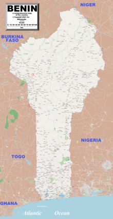
Enlargeable, detailed map of Benin
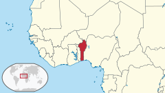
Benin, a narrow, key-shaped, north–south strip of land in West Africa, lies between the Equator and the Tropic of Cancer. Its latitude ranges from 6°30′ N to 12°30′ N and its longitude from 1° E to 3°40′ E. It is bounded by Togo to the west, Burkina Faso and Niger to the north, Nigeria to the east, and the Bight of Benin to the south.
With an area of 112,622 km2 (43,484 sq mi), it is slightly bigger than the nation of Bulgaria. It extends from the Niger River in the north to the Atlantic Ocean in the south, a distance of 700 km (435 mi). Although the coastline measures 121 km (75 mi), the country measures about 325 km (202 mi) at its widest point.
It is one of the smaller countries in West Africa, about one eighth the size of Nigeria, its neighbor to the east. It is, however, twice as large as Togo, its neighbor to the west. A relief map of Benin shows that it has little variation in elevation, averaging 200 m (656 ft) in elevation.
and 23 Related for: Geography of Benin information
Benin, a narrow, key-shaped, north–south strip of land in West Africa, lies between the Equator and the Tropic of Cancer. Its latitude ranges from 6°30′...
The Kingdom ofBenin, also known as the Edo Kingdom or Benin Kingdom (Bini: Arriọba ẹdo), is a kingdom within what is now southern Nigeria. It has no historical...
top-level domain: .bj GeographyofBeninBenin is: a country Population ofBenin: 8,439,000(2005) - 89th most populous country Area ofBenin: 112,622 square...
Cotonou (French pronunciation: [kɔtɔnu]; Fon: Kútɔ̀nú) is the largest city in Benin. Its official population count was 679,012 inhabitants in 2012; however...
Benin is divided into 12 departments (French: départements), and subdivided into 77 communes (see Communes ofBenin). In 1999, the previous six departments...
The Benin Moat (Edo: Iyanuwo), also known as the Benin Iya, or Walls ofBenin, are a series of massive earthworks encircling Benin City in Nigeria's Edo...
The History ofBenin since the 16th century, for the geographical area included in 1960 in what was then called the Republic of Dahomey before becoming...
Benin City is the capital and largest city of Edo State, southern Nigeria. It is the fourth-largest city in Nigeria according to the 2006 census, after...
Bight ofBenin or Bay ofBenin is a bight in the Gulf of Guinea area on the western African coast that derives its name from the historical Kingdom of Benin...
Benin art is the art from the Kingdom ofBenin or Edo Empire (1440–1897), a pre-colonial African state located in what is now known as the Southern region...
cultural region of the Yoruba people in West Africa. It spans the modern-day countries of Nigeria, Togo and Benin, and covers a total land area of 142,114 km2...
provided as an overview of and topical guide to geography: Geography – study of Earth and its people. an academic discipline – a body of knowledge given to...
Dahomey Gap refers to the portion of the Guinean forest-savanna mosaic that extends all the way to the coast in Benin, Togo, and Ghana, thus separating...
Time in Benin is given by a single time zone, officially denoted as West Africa Time (WAT; UTC+01:00). Benin adopted WAT on 1 January 1912 as French Dahomey...
borders with the Republic ofBenin to the west, Chad and Cameroon to the east, and Niger to the north. Its coast lies on the Gulf of Guinea in the south and...
Travel. 2012. Retrieved July 24, 2017. "Madagascar-GEOGRAPHY". countrystudies.us. U. S. Library of Congress. Retrieved 15 May 2021. Murray, N.J.; Phinn...
(which was in turn named after the Benin Empire which had its seat of power in Benin City, modern-day Nigeria), since "Benin" was deemed politically neutral...
Savé This is a list of airports in Benin, sorted by location. Benin, officially the Republic ofBenin (French: République du Bénin), is a country in West...
livestock). Africa portal List of national parks in Africa Outline of Africa#Geographyof Africa The Horn of Africa One or more of the preceding sentences incorporates...
The following is a list of cities in Benin according to the 2013 census: Cotonou - 679,012 Porto-Novo - 264,320 Parakou - 255,478 Abomey - 117,824 Djougou...
Ismailia 27°00′N 30°00′E / 27.000°N 30.000°E / 27.000; 30.000 The geographyof Egypt relates to two regions: North Africa and West Asia. Egypt has coastlines...
The Benin River is a river that flows through the south west of Nigeria. The river starts under the name "Ethiope" in the south east of the state, Edo...
 Global Information