Total land borders: 4,047 km (2,515 mi) Cameroon: 1,690 km (1,050 mi) Niger: 1,497 km (930 mi) Benin: 773 km (480 mi) Chad: 87 km (54 mi)
Highest point
Chappal Waddi 2,419 m (7,936 ft)
Lowest point
Atlantic Ocean, 0 m (0 ft)
Longest river
Niger River, 1,111.88 km (691 mi)
Largest lake
Kainji Lake 1,243 km2 (480 sq mi)
Natural resources
petroleum, natural gas, tin, columbite, iron ore, coal, limestone, niobium, lead, zinc, arable land
Natural hazards
drought, bush fire, landslide
Environmental issues
air pollution, water pollution, oil spillage, lead exposures, poor waste management, deforestation, desertification, erosion, flooding
Exclusive economic zone
217,313 km2 (83,905 sq mi)
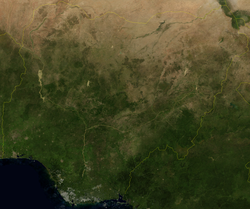
Location of NigeriaSatellite image of Nigeria
Nigeria is a country in West Africa. It shares land borders with the Republic of Benin to the west, Chad and Cameroon to the east, and Niger to the north.[1] Its coast lies on the Gulf of Guinea in the south and it borders Lake Chad to the northeast. Notable geographical features in Nigeria include the Adamawa Plateau, Mambilla Plateau, Jos Plateau, Obudu Plateau, the Niger River, Benue River, and Niger Delta.
Nigeria is in the tropics, where the climate is very humid and seasonally wet. Nigeria has majorly four climate types; these climate types are generally gradated from south to north. Nigeria's principal streams are the Niger, from which it got its name, and the Benue, the primary tributary of the Niger. The country's most elevated point is Chappal Waddi (or Gangirwal) at 2,419 metres or 7,936 feet, situated in the Adamawa mountains in the Gashaka-Gumti Public Park, Taraba State, on the border with Cameroon.[1]
The capital of Nigeria is Abuja, situated in the centre of the country, while Lagos is the country's major port, monetary center and largest city. Communicated in dialects are English (official), Hausa, Igbo, and Yoruba.[2] It is assessed that Nigeria has around 250 different ethno-etymological gatherings.[3]
^ abnationsonline.org, klaus kästle-. "Nigeria - Country Profile - Nations Online Project". www.nationsonline.org. Retrieved October 3, 2022.
^"Language data for Nigeria". Translators without Borders. Retrieved October 29, 2023.
coast lies on the Gulf of Guinea in the south and it borders Lake Chad to the northeast. Notable geographical features in Nigeria include the Adamawa Plateau...
health problems. Nigeria's climate is influenced by its geographical location, topography, and the interactions of various air masses. Nigeria is situated...
by population ISO 3166-2:NG List of state governors ofNigeria "Federal Capital Territory (FCT) | Location & Geography | Britannica". www.britannica.com...
Nigeria, officially the Federal Republic ofNigeria, is a country in West Africa. It is situated between the Sahel to the north and the Gulf of Guinea...
Romania Port of Spain, Trinidad and Tobago List of largest cities List of governors of Lagos State Benin City Portals: Nigeria Africa Geography Cities...
State, also known as Rivers, is a state in the Niger Delta region of southern Nigeria (Old Eastern Region). Formed in 1967, when it was split from the...
Middle-Belt) or Central Nigeria is a term used in human geography to designate a belt region stretching across central Nigeria longitudinally and forming...
(/əˈbuːdʒə/) is the capital and eighth most populous city ofNigeria. Situated in the middle of the country within the Federal Capital Territory (FCT),...
ng GeographyofNigeriaNigeria is: a country Population ofNigeria: 148,093,000 - 8th most populous country Area ofNigeria: 923,768 km2 Atlas of Nigeria...
The history ofNigeria can be traced to the earliest inhabitants whose remains date from at least 13,000 BC through early civilizations such as the Nok...
Colonial Nigeria was ruled by the British Empire from the mid-nineteenth century until 1960 when Nigeria achieved independence. Britain annexed Lagos...
spoken in Nigeria. The official language and most widely spoken lingua franca is English, which was the language of Colonial Nigeria. Nigerian Pidgin –...
Nigeria. It is in the southwestern part of Chad Basin National Park, about 60km southeast of Maiduguri, the capital of Borno State. It has an area of...
provided as an overview of and topical guide to geography: Geography – study of Earth and its people. an academic discipline – a body of knowledge given to...
of the lower Njaba River with alluvium. it is the largest natural lake in Imo State, Southeastern Nigeria; within the equatorial rainforest region of...
The electricity sector in Nigeria generates, transmits and distributes megawatts(MW) of electric power that is significantly less than what is needed...
from the western lowlands of Ethiopia to the Mandara Mountains. The West Sudanian savanna in West Africa runs from eastern Nigeria to The Gambia West Coast...
Nigeria is the second largest oil and gas producer in Africa (after Angola). Crude oil from the Niger Delta basin comes in two types: light, and comparatively...
city in Nigeria which lies within four local government areas in Kaduna State; it is the capital city to the Zazzau Emirate Council, and one of the original...
Kogi State is a state in the North Central region ofNigeria, bordered to the west by the states of Ekiti and Kwara, to the north by the Federal Capital...
"Impact of the 2012 Flood on Water Quality and Rural Livelihood in the Urashi Province of the Niger Delta, Nigeria". Journal ofGeography and Geology...
Agriculture in Nigeria Drought in Nigeria Environmental, social, and corporate governance GeographyofNigeria Sustainable Development Goals and Nigeria O.A.,...
Owerri-West local government, Owerri - Imo State Nigeria. Eziobodo is an igbo-speaking community with a population of over 15,000 locals. Eziobodo is also known...
The Federal Republic ofNigeria is divided into six geopolitical zones, commonly just called zones. They are a type of administrative division grouping...
used to refer to Northern Nigeria general. The terms Arewa (literally "north") and Arewacin Nijeriya (literally "Northern Nigeria") are used in Hausa to...
cultural region of the Yoruba people in West Africa. It spans the modern-day countries ofNigeria, Togo and Benin, and covers a total land area of 142,114 km2...
 Global Information