Geographic coordinate that specifies the east-west position of a point on the Earth's surface
For other uses, see Longitude (disambiguation).
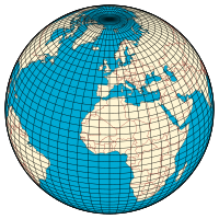
A graticule on the Earth as a sphere or an ellipsoid. The lines from pole to pole are lines of constant longitude, or meridians. The circles parallel to the Equator are circles of constant latitude, or parallels. The graticule shows the latitude and longitude of points on the surface. In this example, meridians are spaced at 6° intervals and parallels at 4° intervals.
Map of Earth
Longitude (λ)
Lines of longitude appear vertical with varying curvature in this projection, but are actually halves of great ellipses, with identical radii at a given latitude.
Latitude (φ)
Lines of latitude appear horizontal with varying curvature in this projection; but are actually circular with different radii. All locations with a given latitude are collectively referred to as a circle of latitude.
The equator divides the planet into a Northern Hemisphere and a Southern Hemisphere, and has a latitude of 0°.
v
t
e
Geodesy
Fundamentals
Geodesy
Geodynamics
Geomatics
History
Concepts
Geographical distance
Geoid
Figure of the Earth (radius and circumference)
Geodetic coordinates
Geodetic datum
Geodesic
Horizontal position representation
Latitude / Longitude
Map projection
Reference ellipsoid
Satellite geodesy
Spatial reference system
Spatial relations
Vertical positions
Technologies
Global Nav. Sat. Systems (GNSSs)
Global Pos. System (GPS)
GLONASS (Russia)
BeiDou (BDS) (China)
Galileo (Europe)
NAVIC (India)
Quasi-Zenith Sat. Sys. (QZSS) (Japan)
Discrete Global Grid and Geocoding
Standards (history)
NGVD 29
Sea Level Datum 1929
OSGB36
Ordnance Survey Great Britain 1936
SK-42
Systema Koordinat 1942 goda
ED50
European Datum 1950
SAD69
South American Datum 1969
GRS 80
Geodetic Reference System 1980
ISO 6709
Geographic point coord. 1983
NAD 83
North American Datum 1983
WGS 84
World Geodetic System 1984
NAVD 88
N. American Vertical Datum 1988
ETRS89
European Terrestrial Ref. Sys. 1989
GCJ-02
Chinese obfuscated datum 2002
Geo URI
Internet link to a point 2010
International Terrestrial Reference System
Spatial Reference System Identifier (SRID)
Universal Transverse Mercator (UTM)
v
t
e
Longitude (/ˈlɒndʒɪtjuːd/, AU and UK also/ˈlɒŋɡɪ-/)[1][2] is a geographic coordinate that specifies the east–west position of a point on the surface of the Earth, or another celestial body. It is an angular measurement, usually expressed in degrees and denoted by the Greek letter lambda (λ). Meridians are imaginary semicircular lines running from pole to pole that connect points with the same longitude. The prime meridian defines 0° longitude; by convention the International Reference Meridian for the Earth passes near the Royal Observatory in Greenwich, south-east London on the island of Great Britain. Positive longitudes are east of the prime meridian, and negative ones are west.
Because of the Earth's rotation, there is a close connection between longitude and time measurement. Scientifically precise local time varies with longitude: a difference of 15° longitude corresponds to a one-hour difference in local time, due to the differing position in relation to the Sun. Comparing local time to an absolute measure of time allows longitude to be determined. Depending on the era, the absolute time might be obtained from a celestial event visible from both locations, such as a lunar eclipse, or from a time signal transmitted by telegraph or radio. The principle is straightforward, but in practice finding a reliable method of determining longitude took centuries and required the effort of some of the greatest scientific minds.
A location's north–south position along a meridian is given by its latitude, which is approximately the angle between the equatorial plane and the normal from the ground at that location.
Longitude is generally given using the geodetic normal or the gravity direction. The astronomical longitude can differ slightly from the ordinary longitude because of vertical deflection, small variations in Earth's gravitational field (see astronomical latitude).
^"Definition of LONGITUDE". Merriam-Webster. Archived from the original on 16 June 2018. Retrieved 14 March 2018.
Longitude (/ˈlɒndʒɪtjuːd/, AU and UK also /ˈlɒŋɡɪ-/) is a geographic coordinate that specifies the east–west position of a point on the surface of the...
measuring and communicating positions directly on the Earth as latitude and longitude. It is the simplest, oldest and most widely used of the various spatial...
celestial mechanics, the longitude of the periapsis, also called longitude of the pericenter, of an orbiting body is the longitude (measured from the point...
In celestial mechanics, true longitude is the ecliptic longitude at which an orbiting body could actually be found if its inclination were zero. Together...
history of longitude describes the centuries-long effort by astronomers, cartographers and navigators to discover a means of determining the longitude of any...
The Longitude Act 1714 was an Act of Parliament of Great Britain passed in July 1714 at the end of the reign of Queen Anne. It established the Board of...
The longitude of the ascending node (symbol ☊) is one of the orbital elements used to specify the orbit of an object in space. It is the angle from a...
Solar longitude, commonly abbreviated as Ls, is the ecliptic longitude of the Sun, i.e. the position of the Sun on the celestial sphere along the ecliptic...
Mean longitude is the ecliptic longitude at which an orbiting body could be found if its orbit were circular and free of perturbations. While nominally...
The Cessna Citation Longitude is a business jet produced by Cessna, part of the Cessna Citation family. It remains the largest business jet by Cessna...
The Longitude Prize is an inducement prize contest offered by Challenge Works, a social enterprise which was historically part of Nesta, a British lottery...
Longitude by chronometer is a method, in navigation, of determining longitude using a marine chronometer, which was developed by John Harrison during...
ship's longitude at sea. The prizes, established through an Act of Parliament (the Longitude Act) in 1714, were administered by the Board of Longitude. This...
The Commissioners for the Discovery of the Longitude at Sea, or more popularly Board of Longitude, was a British government body formed in 1714 to administer...
Longitude Festival is a music festival that takes place during July every year in Dublin, Ireland. Since 2013, Marlay Park has been home to the festival...
and west of the prime meridian in a geographical coordinate system. The longitude at this line can be given as either east or west. On Earth, the prime...
Apparent longitude is celestial longitude corrected for aberration and nutation as opposed to mean longitude. Apparent longitude is used in the definition...
(secondary coordinates) The meridian 169° west of Greenwich is a line of longitude that extends from the North Pole across the Arctic Ocean, the Pacific...
(secondary coordinates) The meridian 80° east of Greenwich is a line of longitude that extends from the North Pole across the Arctic Ocean, Asia, the Indian...
called the International Reference Meridian, is the prime meridian (0° longitude) maintained by the International Earth Rotation and Reference Systems...
between countries and their subdivisions instead of strictly following longitude, because it is convenient for areas in frequent communication to keep...
The Bureau des Longitudes (French: [byʁo de lɔ̃ʒityd]) is a French scientific institution, founded by decree of 25 June 1795 and charged with the improvement...
an arbitrarily-chosen meridian (a line of longitude) in a geographic coordinate system at which longitude is defined to be 0°. Together, a prime meridian...
equator from the Galactic Center. Analogous to terrestrial longitude, galactic longitude is usually measured in degrees (°). Latitude (symbol b) measures...
(secondary coordinates) The meridian 5° east of Greenwich is a line of longitude that extends from the North Pole across the Arctic Ocean, Europe, Africa...
 Global Information