"Anti-Meridian" redirects here. For the Brave Saint Saturn album, see Brave Saint Saturn § Discography.
Not to be confused with ante meridiem (AM), the time before midday, for which see 12-hour clock.
The 180th meridian on a map of Earth.
Map all coordinates using OpenStreetMap
Download coordinates as:
KML
GPX (all coordinates)
GPX (primary coordinates)
GPX (secondary coordinates)
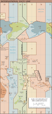
The International Date Line zigzags around the 180th Meridian.
The 180th meridian or antimeridian[1] is the meridian 180° both east and west of the prime meridian in a geographical coordinate system. The longitude at this line can be given as either east or west.
On Earth, the prime and 180th meridians form a great circle that divides the planet into the Western and Eastern Hemispheres. The antimeridian passes mostly through the open waters of the Pacific Ocean but also runs across land in Russia, Fiji, and Antarctica. An important function of this meridian is its use as the basis for the International Date Line, which snakes around national borders to maintain date consistency within the territories of Russia, the United States, Kiribati, Fiji and New Zealand.
Starting at the North Pole of the Earth and heading south to the South Pole, the 180th meridian passes through:
Passing just east of Semisopochnoi Island, Alaska, United States (at 51°57′N179°47′E / 51.950°N 179.783°E / 51.950; 179.783 (Semisopochnoi Island))
Passing just east of Nukulaelae atoll, Tuvalu (at 9°25′S179°52′E / 9.417°S 179.867°E / -9.417; 179.867 (Nukulaelae atoll)) Passing just west of the island of Cikobia-i-Lau, Fiji (at 15°43′S179°59′W / 15.717°S 179.983°W / -15.717; -179.983 (Cikobia))
Passing just east of the island of Moala, Fiji (at 18°33′S179°57′E / 18.550°S 179.950°E / -18.550; 179.950 (Moala)) Passing just west of the island of Totoya, Fiji (at 19°0′S179°52′W / 19.000°S 179.867°W / -19.000; -179.867 (Totoya)) Passing just east of the island of Matuku, Fiji (at 19°10′S179°47′E / 19.167°S 179.783°E / -19.167; 179.783 (Matuku))
90°0′S180°0′E / 90.000°S 180.000°E / -90.000; 180.000 (Amundsen–Scott South Pole Station)
Antarctica
Amundsen–Scott South Pole Station, South Pole
180° Meridian, Taveuni, Fiji. The man pictured is facing southward.
The meridian also passes between (but not particularly close to):
through the Aleutian Island chain of US territory
the Gilbert Islands and the Phoenix Islands of Kiribati
North Island and the Kermadec Islands of New Zealand
the Bounty Islands and the Chatham Islands, also of New Zealand
The only places where roads cross this meridian are in Fiji and Russia. Fiji has several such roads and some buildings very close to it. Russia has three roads in the Chukotka Autonomous Okrug.
^The word antimeridian can also mean the meridian opposite to any given meridian. E.g. 20° west is the antimeridian of 160° east.
(secondary coordinates) The 180thmeridian or antimeridian is the meridian 180° both east and west of the prime meridian in a geographical coordinate...
longitude is defined to be 0°. Together, a prime meridian and its anti-meridian (the 180thmeridian in a 360°-system) form a great circle. This great...
90th meridian east, located midway between the Prime meridian and the 180thmeridian; thus, the center of the Western Hemisphere is on this meridian. In...
meridian. The 90th meridian east forms a great circle with the 90th meridian west. This meridian is halfway between the Prime meridian and the 180th meridian...
Meridian passes through eight countries: 1st meridian east 1st meridian west 180thmeridian Coordinated Universal Time Prime meridian Prime meridian (Greenwich)...
Pole. The 135th meridian east forms a great circle with the 45th meridian west, meaning it is a quarter away from the 180thmeridian and 3 quarters from...
Earth that lies west of the Prime Meridian (which crosses Greenwich, London, England) and east of the 180thmeridian. The other half is called the Eastern...
ranked. There are five countries with territory on both sides of the 180thmeridian, and thus can be said to be both the westernmost and easternmost countries:...
not always reflect the proximity of the country's territory to the 180thmeridian. In such a case there would be three both the very westernmost and the...
lying west of the 180thmeridian, Guam, the Northern Mariana Islands, and Wake Island, most of the country lies east of the 180thmeridian. Kiribati, passing...
to the Pacific Ocean to the north of the equator between 100°E and 180thmeridian. Within the northwestern Pacific Ocean, there are two separate agencies...
Eastern Hemisphere: The half that lies east of the prime meridian and west of the 180thmeridian. This hemisphere includes most of Africa, Europe, Asia...
are limited to the north of the equator between the 100th meridian east and the 180thmeridian (aka Prime Antimeridian). Tropical cyclones portal Tropical...
the Chukchi Sea and East Siberian Sea, the island lies astride the 180thmeridian. The International Date Line is therefore displaced eastwards at this...
on the meridian of 180° longitude, roughly down the middle of the Pacific Ocean, and halfway around the world from the IERS Reference Meridian, the successor...
June solstice, and exactly 45.0° at either equinox. Starting at the Prime Meridian and heading eastwards, the parallel 45° north passes through: In Europe...
equator and the 180thmeridian, the International Date Line goes around Kiribati and swings far to the east, almost reaching the 150°W meridian. This was the...
meridian west. Starting at the North Pole and heading south to the South Pole, the 179th meridian east passes through: 178th meridian east 180thmeridian...
deviates east from its standard course following the 180thmeridian to roughly the 165th meridian west to traverse east of Tonga and other surrounding...
off the coast of Attu to the west, but because both sit west of the 180thmeridian, these two are at times viewed as the easternmost points of the United...
Reference Meridian Leap second Solar time Terrestrial Time Time zone 180thmeridian Obsolete standards Ephemeris time Greenwich Mean Time Prime meridian Time...
north is arbitrarily defined as being along the prime meridian in the Antarctic and the 180thmeridian in the Arctic; thus, east and west on the grids when...
from GMT by a whole number of hours. A nautical date line follows the 180thmeridian, bisecting one 15° gore into two 7.5° gores that differ from GMT by...
meridian east. Starting at the North Pole and heading south to the South Pole, the 179th meridian west passes through: 178th meridian west 180thmeridian...
890 sq mi) of ocean. The islands' spread straddles the equator and the 180thmeridian, although the International Date Line goes around Kiribati and swings...
 Global Information