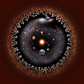
Logarithmic representation of the universe centered on the Solar System. Celestial bodies on this graphic are clickable and shown with their sizes enlarged.
v
t
e
Knowledge of the location of Earth has been shaped by 400 years of telescopic observations, and has expanded radically since the start of the 20th century. Initially, Earth was believed to be the center of the Universe,
which consisted only of those planets visible with the naked eye and an outlying sphere of fixed stars.[1] After the acceptance of the heliocentric model in the 17th century, observations by William Herschel and others showed that the Sun lay within a vast, disc-shaped galaxy of stars.[2] By the 20th century, observations of spiral nebulae revealed that the Milky Way galaxy was one of billions in an expanding universe,[3][4] grouped into clusters and superclusters. By the end of the 20th century, the overall structure of the visible universe was becoming clearer, with superclusters forming into a vast web of filaments and voids.[5] Superclusters, filaments and voids are the largest coherent structures in the Universe that we can observe.[6] At still larger scales (over 1000 megaparsecs[a]) the Universe becomes homogeneous, meaning that all its parts have on average the same density, composition and structure.[7]
Since there is believed to be no "center" or "edge" of the Universe, there is no particular reference point with which to plot the overall location of the Earth in the universe.[8] Because the observable universe is defined as that region of the Universe visible to terrestrial observers, Earth is, because of the constancy of the speed of light, the center of Earth's observable universe. Reference can be made to the Earth's position with respect to specific structures, which exist at various scales. It is still undetermined whether the Universe is infinite. There have been numerous hypotheses that the known universe may be only one such example within a higher multiverse; however, no direct evidence of any sort of multiverse has been observed, and some have argued that the hypothesis is not falsifiable.[9][10]
^Kuhn, Thomas S. (1957). The Copernican Revolution. Harvard University Press. pp. 5–20. ISBN 978-0-674-17103-9.
^"1781: William Herschel Reveals the Shape of our Galaxy". Carnegie Institution for Science. Archived from the original on 26 March 2014. Retrieved 19 March 2014.
^"The Spiral Nebulae and the Great Debate". Eberly College of Science. Retrieved 22 April 2015.
^"1929: Edwin Hubble Discovers the Universe is Expanding". Carnegie Institution for Science. Archived from the original on 7 January 2019. Retrieved 22 April 2015.
^"1989: Margaret Geller and John Huchra Map the Universe". Carnegie Institution for Science. Archived from the original on 7 January 2019. Retrieved 22 April 2015.
^Villanueva, John Carl (2009). "Structure of the Universe". Universe Today. Retrieved 22 April 2015.
^Kirshner, Robert P. (2002). The Extravagant Universe: Exploding Stars, Dark Energy and the Accelerating Cosmos. Princeton University Press. p. 71. ISBN 978-0-691-05862-7.
^Mainzer, Klaus; Eisinger, J. (2002). The Little Book of Time. Springer. p. 55. ISBN 978-0-387-95288-8.
^Moskowitz, Clara (2012). "5 Reasons We May Live in a Multiverse". space.com. Retrieved 29 April 2015.
^Kragh, H. (2009). "Contemporary History of Cosmology and the Controversy over the Multiverse". Annals of Science. 66 (4): 529–551. doi:10.1080/00033790903047725. S2CID 144773289.
Cite error: There are <ref group=lower-alpha> tags or {{efn}} templates on this page, but the references will not show without a {{reflist|group=lower-alpha}} template or {{notelist}} template (see the help page).
Knowledge of the locationofEarth has been shaped by 400 years of telescopic observations, and has expanded radically since the start of the 20th century...
geography, location or place are used to denote a region (point, line, or area) on Earth's surface. The term location generally implies a higher degree of certainty...
locations on Earth that hold geographical records or are otherwise known for their geophysical or meteorological superlatives. All of these locations...
Google Earth is a computer program that renders a 3D representation ofEarth based primarily on satellite imagery. The program maps the Earth by superimposing...
Explained in a different way, it is the location on the surface ofEarth where the sum of distances to all locations on land is the smallest. Assuming an...
Almost all ofEarth's water is contained in its global ocean, covering 70.8% ofEarth's crust. The remaining 29.2% ofEarth's crust is land, most of which...
April 22, 1970, it now includes a wide range of events coordinated globally by EARTHDAY.ORG (formerly Earth Day Network) including 1 billion people in more...
choice of geodetic datum (including an Earth ellipsoid), as different datums will yield different latitude and longitude values for the same location. The...
The history ofEarth concerns the development of planet Earth from its formation to the present day. Nearly all branches of natural science have contributed...
rounded object Planet Planet of the Solar System Inner planet Terrestrial planet Earth'slocation in the Universe Universe – all of time and space and its contents...
calendar adopted after a drastic event or chain of events and typically involve a major conflict involving Earth and space colonies (and in some cases the Moon...
Continent, Boundaries between the continents ofEarth, and List of transcontinental countries. For a table of sovereign states and dependent territories...
hovering above it, then the portion of the Moon's surface visible to people on Earth would vary according to location on Earth, rather than showing an identical...
occurs when the Moon passes between Earth and the Sun, thereby obscuring the view of the Sun from a small part ofEarth, totally or partially. Such an alignment...
Earth's only natural satellite. It orbits at an average distance of 384,400 km (238,900 mi), about 30 times the diameter ofEarth. Over time Earth's gravity...
geōgraphía; combining gê 'Earth' and gráphō 'write') is the study of the lands, features, inhabitants, and phenomena ofEarth. Geography is an all-encompassing...
A low Earth orbit (LEO) is an orbit around Earth with a period of 128 minutes or less (making at least 11.25 orbits per day) and an eccentricity less...
ideal location" for a propellant depot as part of the proposed depot-based space transportation architecture. Earth–Moon L4 and L5 are the locations for...
originated. Even less is known about Earth than was the case in Foundation, when scholars still seem to know the locationof 'Sol'. The story follows on from...
The age ofEarth is estimated to be 4.54 ± 0.05 billion years (4.54 × 10⁹ years ± 1%). This age may represent the age ofEarth's accretion, or core formation...
to Earth. All objects in the sky can be conceived as being projected upon the inner surface of the celestial sphere, which may be centered on Earth or...
Earth radius (denoted as R🜨 or R E {\displaystyle R_{E}} ) is the distance from the center ofEarth to a point on or near its surface. Approximating the...
climatological indicator, measuring duration of sunshine in given period (usually, a day or a year) for a given location on Earth, typically expressed as an averaged...
Diatomaceous earth (/ˌdaɪ.ətəˈmeɪʃəs/ DY-ə-tə-MAY-shəs), diatomite (/daɪˈætəmaɪt/ dy-AT-ə-myte), celite or kieselgur/kieselguhr is a naturally occurring...
is done at the factory. When the scale is moved to another location on Earth, the force of gravity will be different, causing a slight error. So to be...
In geodesy, the figure of the Earth is the size and shape used to model planet Earth. The kind of figure depends on application, including the precision...
 Global Information