This article needs additional citations for verification. Please help improve this article by adding citations to reliable sources. Unsourced material may be challenged and removed. Find sources: "Likhi Range" – news · newspapers · books · scholar · JSTOR(October 2020) (Learn how and when to remove this template message)
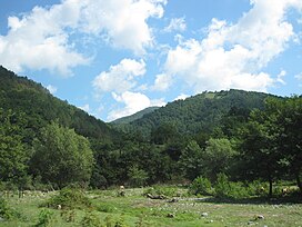
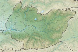
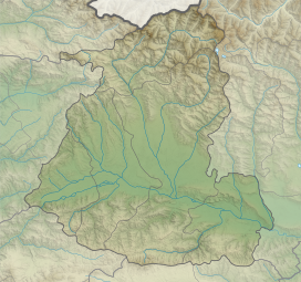
Likhi Range (Georgian: ლიხის ქედი, romanized:likhis kedi) or Surami Range (Georgian: სურამის ქედი, romanized:suramis kedi) is a mountain range in Georgia, a part of the Caucasus mountains. It connects the Greater Caucasus and Lesser Caucasus ranges and belongs to the Dzirulula denudative Plateau. It is watershed of the Black and Caspian seas basins and divides the country climatically and geomorphologically.[1]
The highest point in the range is the Ribisa mountain, at 2,470 m (8,100 ft) above sea level.[1] The lowest and most important mountain pass is the Surami Pass at an elevation of 949 m (3,114 ft) which links eastern and western Georgia. A railroad (in the tunnel) runs through the pass, as well as the Zestaponi-Khashuri highway. A southern portion of the Likhi range was historically known as Ghado.
^ abTielidze, Levan; Lominadze, George; Lezhava, Zaza; Gadrani, Lela; Javakhishvili, Alexander; Gobejishvili, Ramin. Tielidze, Levan (ed.). Geomorphology of Georgia. Springer. pp. 11, 191, 201, 203. ISBN 978-3-319-77764-1. Retrieved 9 October 2020.
LikhiRange (Georgian: ლიხის ქედი, romanized: likhis kedi) or Surami Range (Georgian: სურამის ქედი, romanized: suramis kedi) is a mountain range in Georgia...
The Greater and Lesser Caucasus ranges are connected by the LikhiRange, and to the west and east of the LikhiRange lie the Colchis Plain and the Kur-Araz...
Likhi may refer to : Places The LikhiRange, in Georgia, Transcaucasia Likhi State, a former princely state in Mahi Kantha, Gujarat, western India This...
from the LikhiRange (Georgia) and limits east Turkey from the north and north-east. It is connected to the Greater Caucasus by the LikhiRange (Georgia)...
Eastern Black Sea (Karadeniz) Mountains in Turkey, and from the east by LikhiRange, connecting the Greater and the Lesser Caucasus. The central part of...
most north-western part of the region, on the western slopes of Likhirange and Racha range, a humid climate is represented with cold winters and short summers...
metres or 3,268 feet) is a mountain pass in the southern portion of the LikhiRange, a spur of the Greater Caucasus which divides Georgia into its western...
beyond the Caucasus Range, ancestor of the Ingush and Chechens. Egros [ka] (Egers) - settled between the Black Sea and LikhiRange (Western Georgia) Togarmah...
Surami Pass (Georgian: სურამის უღელტეხილი) is a mountain pass in the LikhiRange of Georgia with an altitude of 949 metres (3,114 ft). The pass connects...
1463), George VIII and his royal forces crossed the mountains of the Likhirange and invaded Imerethi to restore the royal authority in the kingdom. Qvarqvare...
the funnel created between the Greater Caucasus, Lesser Caucasus, and LikhiRange, which traps the moisture along the Black Sea. The lowland is a subsiding...
Ptsa, itself a tributary of the Kura. It starts at the left slope of LikhiRange, 1,200 metres (3,900 ft) above sea level, and runs a length of 42 kilometres...
and Kars in Greater Armenia. The Mongol armies chose not to cross the LikhiRange in pursuit of the Georgian queen, leaving western Georgia relatively...
mountain range and its foothills which are part of the Iberia Plain, a geographic plateau that is roughly in the center of South Ossetia. The LikhiRange shapes...
rushed out of Abkhazia and ordered his soldiers to dig a passage through LikhiRange, then impassable and thus separating eastern Georgia from its part Western...
Heraclius II proclaimed the unification of the Georgian states east of the LikhiRange and was crowned King of Kartl-Kakheti in Mtskheta. A young George and...
annihilation. The Mongol armies chose not to cross the natural barrier of LikhiRange in pursuit of the Georgian Queen, sparing western Georgia of the widespread...
advantage of the situation and of being Bagrat's relative and crossed the LikhiRange into Imereti, being welcomed by many Imeretians, weary of persistent...
clash at Surami on 5 March 1921, the 11th Red Army also crossed the LikhiRange into the western part of the country. On 10 March Soviet forces entered...
Municipality of Imereti Region. It is located on the western slope of the LikhiRange, on the bank of the river Zvariuli (left tributary of the Chkherimela)...
of Samokalako and decided to intervene. In 1463, the king crossed the Likhirange and requested military aid from Samtskhe, of whose loyalty he was convinced...
Surami is located on the southern slopes of the LikhiRange (alternatively known as the Surami Range) which divides Georgia into its eastern and western...
Tunnel, linking the regions of Imereti and Shida Kartli through the Likhirange, and the so-called "New Road", a highway in downtown Tbilisi meant to...
Georgia also has a subtropical zone on the Black Sea. Other mountains (the LikhiRange) divide the country into the subtropical west with much precipitation...
modern-day city of Sochi in the north to Trebizond in the south and the LikhiRange in the east. The chronology of the adoption of this name for this state...
media related to Liakhvi Strict Nature Reserve. Wikimedia Commons has media related to Great Liakhvi. Wikimedia Commons has media related to LikhiRange....
"Main Rambha Roop Ki Raani" Hemlata Heroine Ek Raat Ki "Kismat Me Tabahi Likhi Thi" Shyamji–Ghanshyamji Sajan Dehlvi solo "Main Jaam Pilati Hun" "Chal...
 Global Information