Illinois tributary of the Mississippi River in the United States
This article is about the river in Illinois. For the rivers of Illinois, see List of rivers of Illinois. For other uses, see Illinois River (disambiguation).
Illinois River
Illinois River valley, Abraham Lincoln Memorial Bridge, and LaSalle Rail Bridge near LaSalle, Illinois
Valley City, about 61.8 mi (99.5 km) from the mouth[1]
• average
23,280 cu ft/s (659 m3/s)[1]
• minimum
1,330 cu ft/s (38 m3/s)
• maximum
123,000 cu ft/s (3,500 m3/s)
Basin features
Progression
Illinois → Mississippi → Gulf of Mexico
Tributaries
• left
Kankakee River, Mazon River, Vermilion River, Mackinaw River, Sangamon River
• right
Des Plaines River, Fox River, Illinois and Michigan Canal
[2][3]
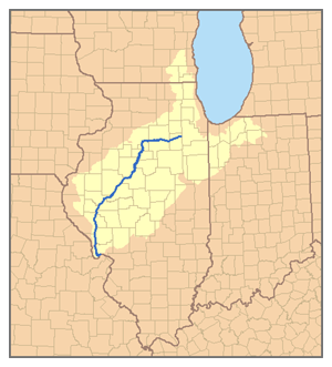
The Illinois River (Miami-Illinois: Inoka Siipiiwi[4]) is a principal tributary of the Mississippi River at approximately 273 miles (439 km) in length. Located in the U.S. state of Illinois,[5] the river has a drainage basin of 28,756.6 square miles (74,479 km2).[6] The Illinois River begins with the confluence of the Des Plaines and Kankakee rivers in the Chicago metropolitan area, and it generally flows to the southwest across Illinois, until it empties into the Mississippi near Grafton, Illinois. Its drainage basin extends into southeastern Wisconsin, northwestern Indiana, and a very small area of southwestern Michigan in addition to central Illinois. Along its shores are several river ports, including Peoria, Illinois. Historic and recreation areas on the river include Starved Rock, and the internationally important wetlands of the Emiquon Complex and Dixon Waterfowl Refuge.
The river was important among Native Americans and early French traders as the principal water route connecting the Great Lakes with the Mississippi. The French colonial settlements along these rivers formed the heart of the area known as the Illinois Country in the 17th and 18th centuries. After the construction of the Illinois and Michigan Canal and the Hennepin Canal in the 19th century, the role of the river as link between Lake Michigan and the Mississippi was extended into the era of modern industrial shipping. The Illinois now forms the basis for the Illinois Waterway, extending the river's capabilities for navigation and commercial shipping.
^ ab"USGS Gage #05586100 on the Illinois River at Valley City, IL" (PDF). National Water Information System. U.S. Geological Survey. 1939–2012. Archived (PDF) from the original on May 15, 2019. Retrieved November 9, 2013.
^"Illinois River". Geographic Names Information System. United States Geological Survey, United States Department of the Interior.
^Rivergauges.com Archived April 8, 2009, at the Wayback Machine
^"Aacimotaatiiyankwi : a Myaamia Community Bog". Archived from the original on September 1, 2018. Retrieved April 22, 2018.
^Riverweb Illinois River basics Archived June 1, 2016, at the Wayback Machine
^NHDPlus v2.1 Watershed Characterization Report Archived February 2, 2017, at the Wayback Machine
The IllinoisRiver (Miami-Illinois: Inoka Siipiiwi) is a principal tributary of the Mississippi River at approximately 273 miles (439 km) in length. Located...
northeast, the Mississippi River to its west, and the Wabash and Ohio rivers to its south. Of the fifty U.S. states, Illinois has the fifth-largest gross...
Mississippi River itself and its numerous natural tributaries and distributaries. The major tributaries are the Illinois, Missouri, Ohio and Red rivers. Given...
Mississippi River watershed, French colonial settlement was concentrated along the Mississippi and IllinoisRivers in what is now the U.S. states of Illinois and...
thirteenth-largest river by discharge in the world. The river either borders or passes through the states of Minnesota, Wisconsin, Iowa, Illinois, Missouri, Kentucky...
the river, creating two alignments between New Orleans and Hastings-Point Douglas. Signs marking the National Route are now used only in Illinois and...
of rivers in the U.S. state of Illinois: Mississippi River Ohio River Lusk Creek Saline River Wabash River Little Wabash River Skillet Fork Elm River Fox...
Mississippi River Basin, and ultimately the Gulf of Mexico. The river is also noteworthy for its natural and human-engineered history. In 1887, the Illinois General...
Mississippi River, except for a few areas where the river has changed course. Illinois' southeastern and southern boundary is along the Wabash River and the...
five major bodies of water. With the Kankakee River, the IllinoisRiver watershed stretches from the Illinois border in northwest Indiana and up into Michigan's...
Chicago to the mouth of the IllinoisRiver at Grafton, Illinois. Based primarily on the IllinoisRiver, it is a system of rivers, lakes, and canals that provide...
The Kankakee River is a tributary of the IllinoisRiver, approximately 133 miles (214 km) long, in the Central Corn Belt Plains of northwestern Indiana...
The Illinois and Michigan Canal connected the Great Lakes to the Mississippi River and the Gulf of Mexico. In Illinois, it ran 96 miles (154 km) from the...
Corporation River Bend (Illinois) River Bend, West Virginia Riverbend (disambiguation) This disambiguation page lists articles associated with the title River Bend...
the Kankakee River west of Channahon to form the IllinoisRiver, a tributary of the Mississippi River. Native Americans used the river as transportation...
The Sangamon River is a principal tributary of the IllinoisRiver, approximately 246 miles (396 km) long, in central Illinois in the United States. It...
The Illinois Confederation, also referred to as the Illiniwek or Illini, were made up of 12 to 13 tribes who lived in the Mississippi River Valley. Eventually...
 Global Information