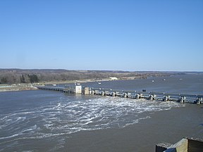
The Illinois Waterway at Starved Rock Lock and Dam
Historical map of the I&M Canal. While later construction would create the Illinois Waterway, it generally follows a similar route as shown in the inset.
Location
Northern / Central Illinois
Country
United States
Specifications
Length
336 miles (541 km)
Maximum boat draft
9 feet (2.7 m)
Locks
8
Total rise
158 feet (48 m)
Status
Open
Navigation authority
U.S. Army Corps of Engineers
Geography
Start point
Lake Michigan
End point
Mississippi River
Connects to
Great Lakes Waterway
The Illinois Waterway system consists of 336 miles (541 km) of navigable water from the mouth of the Calumet River at Chicago to the mouth of the Illinois River at Grafton, Illinois. Based primarily on the Illinois River, it is a system of rivers, lakes, and canals that provide a shipping connection from the Great Lakes to the Gulf of Mexico via the Illinois and Mississippi rivers.
The Illinois and Michigan Canal (I&M) opened in 1848. In 1900, the Chicago Sanitary and Ship Canal replaced the I&M and reversed the flow of the Chicago River so it no longer flowed into Lake Michigan. The United States Army Corps of Engineers maintains a 9-foot-deep (2.7 m) navigation channel in the waterway.[1] The waterway's complex northern section is referred to in various contexts for study and management as the Chicago Area Waterway System (CAWS).
Cargoes include bulk commodities, such as coal, chemicals, and petroleum, as well as corn, soybeans and other agricultural products. During some winters, ice floes, especially around the locks and dams, occasionally prevent navigation on the Waterway.
^United States Army Corps of Engineers. "Chapter 6. The Illinois Waterway Archived 2011-07-09 at the Wayback Machine". page 3. June 3, 2005. (Dead link)
The IllinoisWaterway system consists of 336 miles (541 km) of navigable water from the mouth of the Calumet River at Chicago to the mouth of the Illinois...
The Illinois now forms the basis for the IllinoisWaterway, extending the river's capabilities for navigation and commercial shipping. The Illinois River...
Seaway and to the Gulf of Mexico from the Mississippi River via the IllinoisWaterway. Chicago has been the nation's railroad hub since the 1860s, and its...
Ocean, while the IllinoisWaterway extends commercial shipping to the Mississippi River and the Gulf of Mexico. The Great Lakes Waterway is co-administered...
Mississippi River System is connected to the IllinoisWaterway, which continues to the Great Lakes Waterway and then to the Saint Lawrence Seaway. Many...
ceased transportation operations with the completion of the IllinoisWaterway in 1933. Illinois and Michigan Canal Locks and Towpath, a collection of eight...
Lock and Dam at Chicago, Illinois is a guard lock that controls the outflow of water from Lake Michigan into the IllinoisWaterway while locking vessels...
Lakes Waterway and St. Lawrence Seaway, or by the Erie Canal and the Hudson River, or via the Gulf of Mexico from the Mississippi River and the Illinois Waterway...
Lakes and the Mississippi River and makes up the northern end of the IllinoisWaterway. The CAWS includes various branches of the Chicago and Calumet Rivers...
its valley. Parts of the river are now part of the IllinoisWaterway and the Chicago Area Waterway System. The slow-moving Des Plaines River rises in...
inland waterways which are connected by artificial means. Important connecting waterways include the IllinoisWaterway, the Tennessee-Tombigbee Waterway, and...
canal's opening and was shut down entirely with the creation of the IllinoisWaterway network in 1933. The building of the Chicago canal served as intensive...
in the United States: This list includes active canals and artificial waterways that are maintained for use by boats. Although some abandoned canals and...
of the IllinoisWaterway and the Mississippi River. In 1951, the Illinois General Assembly authorized the creation of port districts in Illinois with the...
Several of his works built in the 1920s and 1930s as part of the IllinoisWaterway project are listed on the National Register of Historic Places, including...
"Chapter 6. The IllinoisWaterway Archived 9 July 2011 at the Wayback Machine". page 3. 3 June 2005. Water Chemistry of the IllinoisWaterway Archived 14...
Chicago Portage was an ancient portage that connected the Great Lakes waterway system with the Mississippi River system. Connecting these two great water...
Channel to the Des Plaines River. The waterway passes Joliet and soon becomes the Illinois River. The Illinois River travels west, through several locks...
into Illinois, then turning back east to its mouth at Lake Michigan at Marquette Park in Gary. Now the system is part of the Chicago Area Waterway System...
the IllinoisWaterway to the Gulf of Mexico via the Illinois River and the Mississippi River. Commercial tug-and-barge traffic on these waterways is heavy...
U.S. Army Corps of Engineers along the Illinois River, near Starved Rock. It is part of the IllinoisWaterway and was constructed between 1926 and 1933...
 Global Information