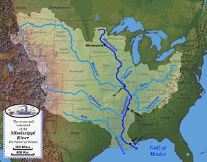
The Mississippi River System, also referred to as the Western Rivers, is a mostly riverine network of the United States which includes the Mississippi River and connecting waterways. The Mississippi River is the largest drainage basin in the United States.[3] In the United States, the Mississippi drains about 59% of the country's rivers.[4]
From the perspective of natural geography and hydrology, the system consists of the Mississippi River itself and its numerous natural tributaries and distributaries. The major tributaries are the Illinois, Missouri, Ohio and Red rivers. Given their flow volumes, major Ohio River tributaries like the Allegheny, Tennessee, and Wabash rivers are considered important tributaries to the Mississippi system.[5] Before the Mississippi River reaches the Gulf of Mexico, it runs into its distributary, the Atchafalaya River.[3]
From the perspective of modern commercial navigation, the system includes the above as well as navigable inland waterways which are connected by artificial means. Important connecting waterways include the Illinois Waterway, the Tennessee-Tombigbee Waterway, and the Gulf Intracoastal Waterway. is maintained by the U.S. Army Corps of Engineers with a project depth of between 9–12 ft (2.7–3.7 m) to accommodate barge transportation, primarily of bulk commodities.[6]
The Mississippi River carries 60% of U.S. grain shipments, 22% of oil and gas shipments, and 20% of coal.[7]
^ abKammerer, J.C. (May 1990). "Largest Rivers in the United States". U.S. Geological Survey. Archived from the original on June 30, 2017. Retrieved February 22, 2011.
^ abMedian of the 14,610 daily streamflows recorded by the USGS for the period 1967–2006.
^ ab"The Mississippi/Atchafalaya River Basin (MARB)". www.epa.gov. US Environmental Protection Agency. 24 March 2015. Retrieved 2 November 2016.
^Cite error: The named reference Watkins was invoked but never defined (see the help page).
^"Mississippi River". USGS Biological Resources. Archived from the original on 2005-10-28. Retrieved 2006-03-08.
^"The Mississippi River System". US Army Corps of Engineers. Archived from the original on 2006-04-09. Retrieved 2006-03-08.
^Alan Greenblatt (2013-01-10). "Mississippi Blues: When The River Doesn't Run". NPR. Retrieved 2015-11-26.
and 22 Related for: Mississippi River System information
The MississippiRiverSystem, also referred to as the Western Rivers, is a mostly riverine network of the United States which includes the Mississippi River...
The MississippiRiver is the primary river, and second-longest river, of the largest drainage basin in the United States. From its traditional source of...
The MississippiRiver Delta is the confluence of the MississippiRiver with the Gulf of Mexico in Louisiana, southeastern United States. The river delta...
MississippiRiver is the portion of the MississippiRiver downstream of Cairo, Illinois. From the confluence of the Ohio River and Upper Mississippi River...
throughout the MississippiRiverSystem. Tritium concentrations can be used to understand the residence times of continental hydrologic systems (as opposed...
The Upper MississippiRiver is today the portion of the MississippiRiver upstream of St. Louis, Missouri, United States, at the confluence of its main...
The Old River Control Structure is a floodgate system in a branch of the MississippiRiver in central Louisiana. It regulates the flow of water from the...
States consist of the MississippiRiverSystem—the MississippiRiver and connecting waterways. The Columbia River is the only river on the West Coast (and...
important industry on the rivers of the MississippiRiversystem, there are a number of fireboats on the MississippiRiversystem. Since al Qaeda's attacks...
the Mississippi, the Missouri River is slightly longer and carries a comparable volume of water. When combined with the lower MississippiRiver, it forms...
The Great Mississippi Flood of 1927 was the most destructive river flood in the history of the United States, with 27,000 square miles (70,000 km2) inundated...
The Arkansas River is a major tributary of the MississippiRiver. It generally flows to the east and southeast as it traverses the U.S. states of Colorado...
This is a list of bridges and other crossings of the Lower MississippiRiver from the Ohio River downstream to the Gulf of Mexico. Locations are listed with...
navigation for ships between the Great Lakes Waterway and the MississippiRiversystem. The canal was in part built as a sewage treatment scheme. Prior...
River (/əˌtʃæf.əˈlaɪ.ə/ French: La Rivière Atchafalaya, Spanish: Río Atchafalaya) is a 137-mile-long (220 km) distributary of the MississippiRiver and...
Engineers Mississippi Valley Division (MVD) is responsible for the Corps water resources programs within 370,000-square-miles of the MississippiRiver Valley...
to the northwest. Mississippi's western boundary is largely defined by the MississippiRiver, or its historical course. Mississippi is the 32nd largest...
The Great River Road is a collection of state and local roads that follow the course of the MississippiRiver through ten states of the United States...
a tributary of the MississippiRiver, the Red River is now a tributary of the Atchafalaya River, a distributary of the Mississippi that flows separately...
31583°W / 32.30611; -90.31583 The MississippiRiver Basin Model Waterways Experiment Station, located near Clinton, Mississippi, was a large-scale hydraulic...
United States, transporting bulk liquid products throughout the MississippiRiverSystem, on the Gulf Intracoastal Waterway, along all three U.S. Coasts...
Major floods along the MississippiRiver in April and May 2011 were among the largest and most damaging recorded along the U.S. waterway in the past century...
 Global Information