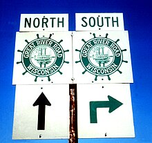
The distinctive route marker displayed along the entire 10-state routing of the Great River Road
The Great River Road is a collection of state and local roads that follow the course of the Mississippi River through ten states of the United States. They are Minnesota, Wisconsin, Iowa, Illinois, Missouri, Kentucky, Tennessee, Arkansas, Mississippi and Louisiana. It formerly extended north into Canada, serving the provinces of Ontario and Manitoba. The road is designated as both a National Scenic Byway and an All-American Road in several states along the route.[2]
The term "Great River Road" refers both to a series of roadways and to a larger region inside the US and in each state, used for tourism and historic purposes. Some states have designated or identified regions of state interest along the road and use the roads to encompass those regions.[3]
It is divided into two main sections: the Great River Road and the National Scenic Byway Route. The eponymous segment runs on both sides of the river from Louisiana through the state borders of Kentucky/Illinois and Missouri/Iowa, excepting the full length of the road in Arkansas. A five-state section of the road has been designated a National Scenic Byway, running through Arkansas, Illinois, Iowa, Wisconsin, and Minnesota. In 2021, eight of the 10 state routes were designated All-American Roads by the Federal Highway Administration,[4] highlighting their national significance and one-of-a-kind features.[5]
Developed in 1938, the road has a separate commission in each state. These in turn cooperate through the Mississippi River Parkway Commission (MRPC). The 2,340 miles (3,765 km) are designated with a green-and-white sign showing a river steamboat inside a pilotwheel with the name of the state or province. The over-all logo reads "Canada to Gulf" where the local name would be, and most MRPC publications denote the route as beginning at Lake Itasca in Minnesota and ending in Louisiana.
^Staff. "Great River Road". America's Byways. Federal Highway Administration. Retrieved August 28, 2014.
^"Collection of America's Byways[reg] Designated by U.S. Secretary of Transportation - Designations - National Scenic Byways Program - Planning, Environment, & Real Estate - FHWA". www.fhwa.dot.gov. Retrieved August 18, 2021.
^Staff. "Explore Minnesota's Great River Road". Minnesota Mississippi River Parkway Commission. Retrieved April 1, 2012.
^Hecox, Doug (February 16, 2021). "USDOT Announces New America's Byways® Designations" (Press release). Federal Highway Administration. FHWA 03-21. Retrieved August 18, 2021.
^"Great River Road receives All-American Road designation". Experience Mississippi River. February 16, 2021. Retrieved August 18, 2021.
List of A roads in zone 1 in Great Britain beginning north of the River Thames, east of the A1 (roads beginning with 1). "Old Stoke Bridge, Ipswich"....
List of A roads in zone 2 in Great Britain starting south of the River Thames and east of the A3 (roads beginning with 2). Wikimedia Commons has media...
List of A roads in zone 4 in Great Britain starting north of the A4 and south/west of the A5 (roads beginning with 4). Only roads that have individual...
roads in zone 3 in Great Britain starting west of the A3 and south of the A4 (roads beginning with 3). Wikimedia Commons has media related to A roads...
List of A roads in zone 5 in Great Britain starting north/east of the A5, west of the A6, south of the Solway Firth/Eden Estuary (roads beginning with...
The Great Ocean Road is an Australian National Heritage-listed 240-kilometre (150 mi) stretch of road along the south-eastern coast of Australia, between...
The Great Platte RiverRoad was a major overland travel corridor approximately following the course of the Platte River in present-day Nebraska and Wyoming...
RiverRoad may refer to: Barbuda-South RiverRoad, Antigua and Barbuda RiverRoad, Hamilton, New Zealand RiverRoad, North Carolina, US RiverRoad, Oregon...
The GreatRiverRoad Bridge, officially known as US 52 over CP RR/Mill Creek, and often called Mill Creek Overpass, or the South Bellevue Bridge, is steel...
The Great Wagon Road was an improved trail through the Great Appalachian Valley from Pennsylvania to North Carolina, and from there to Georgia in colonial...
99°02′18″W / 40.669747°N 99.038342°W / 40.669747; -99.038342 The Great Platte RiverRoad Archway Monument (also known as The Archway or Kearney Archway)...
GreatRiverRoad State Park is a public recreation area in the U.S. state of Mississippi located off Mississippi Highway 1 in the southwest corner of the...
RiverGreat Ouse (/uːz/ ooz) is a river in England, the longest of several British rivers called "Ouse". From Syresham in Northamptonshire, the Great...
misidentified with the GreatRiverRoad that traverses along the banks of the Mississippi River through multiple states. The road also designates the eastern...
road from Warburton to Docker River which bypassed part of the twenty-year-old Gunbarrel Highway. The Great Central Road and original Gunbarrel Highway...
Maurya and was inspired by the Persian Royal Road (more precisely, its eastern stretch, the Great Khurasan Road that ran from Media to Bactria). During the...
The Great Britain road numbering scheme is a numbering scheme used to classify and identify all roads in Great Britain. Each road is given a single letter...
northernmost point and moving clockwise, the roads defining the boundary are Pentonville Road, City Road, Old Street, Great Eastern Street, Commercial Street, Mansell...
The Great East Road is a major road in Zambia and the main route linking its Eastern Province with the rest of the country. It is also the major link...
Settlers from Pennsylvania tended to migrate south along the Great Wagon Road through the Great Appalachian Valley and Shenandoah Valley. Daniel Boone was...
Moines River was opened at the end of 2004, replacing an existing toll bridge operated by the Wayland Special Road District. A new four-lane road between...
and uptown, following the curve of the river's crescent bend before coming to its terminus, hitting East Road at Audubon Park. The equivalent street on...
Mississippi River Chemetco GreatRiverRoad List of crossings of the Lower Mississippi River List of crossings of the Upper Mississippi River List of locks...
 Global Information