Illustration of a Cartesian coordinate plane. Four points are marked and labeled with their coordinates: (2, 3) in green, (−3, 1) in red, (−1.5, −2.5) in blue, and the origin (0, 0) in purple.
In geometry, a Cartesian coordinate system (UK: /kɑːrˈtiːzjən/, US: /kɑːrˈtiːʒən/) in a plane is a coordinate system that specifies each point uniquely by a pair of real numbers called coordinates, which are the signed distances to the point from two fixed perpendicular oriented lines, called coordinate lines, coordinate axes or just axes (plural of axis) of the system. The point where they meet is called the origin and has (0, 0) as coordinates.
Similarly, the position of any point in three-dimensional space can be specified by three Cartesian coordinates, which are the signed distances from the point to three mutually perpendicular planes. More generally, n Cartesian coordinates specify the point in an n-dimensional Euclidean space for any dimension n. These coordinates are the signed distances from the point to n mutually perpendicular fixed hyperplanes.
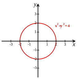
Cartesian coordinate system with a circle of radius 2 centered at the origin marked in red. The equation of a circle is (x − a)2 + (y − b)2 = r2 where a and b are the coordinates of the center (a, b) and r is the radius.
Cartesian coordinates are named for René Descartes, whose invention of them in the 17th century revolutionized mathematics by allowing the expression of problems of geometry in terms of algebra and calculus. Using the Cartesian coordinate system, geometric shapes (such as curves) can be described by equations involving the coordinates of points of the shape. For example, a circle of radius 2, centered at the origin of the plane, may be described as the set of all points whose coordinates x and y satisfy the equation x2 + y2 = 4; the area, the perimeter and the tangent line at any point can be computed from this equation by using integrals and derivatives, in a way that can be applied to any curve.
Cartesian coordinates are the foundation of analytic geometry, and provide enlightening geometric interpretations for many other branches of mathematics, such as linear algebra, complex analysis, differential geometry, multivariate calculus, group theory and more. A familiar example is the concept of the graph of a function. Cartesian coordinates are also essential tools for most applied disciplines that deal with geometry, including astronomy, physics, engineering and many more. They are the most common coordinate system used in computer graphics, computer-aided geometric design and other geometry-related data processing.
and 24 Related for: Cartesian coordinate system information
In geometry, a Cartesiancoordinatesystem (UK: /kɑːrˈtiːzjən/, US: /kɑːrˈtiːʒən/) in a plane is a coordinatesystem that specifies each point uniquely...
unique coordinate and each real number is the coordinate of a unique point. The prototypical example of a coordinatesystem is the Cartesiancoordinate system...
reference systems that are in use, and forms the basis for most others. Although latitude and longitude form a coordinate tuple like a cartesiancoordinate system...
direction. The reference point (analogous to the origin of a Cartesiancoordinatesystem) is called the pole, and the ray from the pole in the reference...
national systems such as the British National Grid, and State Plane CoordinateSystem (SPCS). Engineering coordinatesystem (or local, custom) A cartesian coordinate...
A Cartesiancoordinate robot (also called linear robot) is an industrial robot whose three principal axes of control are linear (i.e. they move in a straight...
category theory Cartesiancoordinatesystem, modern rectangular coordinatesystemCartesian diagram, a construction in category theory Cartesian geometry, now...
In mathematics, a spherical coordinatesystem is a coordinatesystem for three-dimensional space where the position of a given point in space is specified...
simple Cartesiancoordinatesystem to specify locations rather than a more complex spherical coordinatesystem (the geographic coordinatesystem of latitude...
are a coordinatesystem for Euclidean space in which the coordinate lines may be curved. These coordinates may be derived from a set of Cartesian coordinates...
A projected coordinatesystem – also called a projected coordinate reference system, planar coordinatesystem, or grid reference system – is a type of...
topics. Later, the plane was described in a so-called Cartesiancoordinatesystem, a coordinatesystem that specifies each point uniquely in a plane by a...
strongly related to Cartesian coordinates and, more generally, affine coordinates. For a space of dimension n, these coordinatesystems are defined relative...
absolute coordinatesystem uses the cartesiancoordinatesystem, where a point on the machine is specifically defined. The cartesiancoordinatesystem is a...
the Cartesian xy-plane (with equation z = 0), and the cylindrical axis is the Cartesian z-axis. Then the z-coordinate is the same in both systems, and...
position such as (5, 2, 1) in a 3-dimensional Cartesiancoordinatesystem with the basis as the axes of this system. Coordinates are always specified relative...
analytic geometry, also known as coordinate geometry or Cartesian geometry, is the study of geometry using a coordinatesystem. This contrasts with synthetic...
Cartesianism is the philosophical and scientific system of René Descartes and its subsequent development by other seventeenth century thinkers, most notably...
first and second coordinate of a point in a Cartesiancoordinatesystem: abscissa ≡ x {\displaystyle \equiv x} -axis (horizontal) coordinate, ordinate ≡ y...
can be approximated with the Cartesiancoordinatesystem. The curve geometry of cylinder in Cartesiancoordinatesystem is approximated by using stepwise...
drawn from up to down (or down to up), such as the y-axis in the Cartesiancoordinatesystem. The word horizontal is derived from the Latin horizon, which...
 Global Information