This article needs additional citations for verification. Please help improve this article by adding citations to reliable sources. Unsourced material may be challenged and removed. Find sources: "Atlantic seaboard watershed" – news · newspapers · books · scholar · JSTOR(May 2014) (Learn how and when to remove this message)
Atlantic Seaboard
Watershed
The Atlantic Seaboard Watershed extends southward along the Atlantic Ocean from Nova Scotia to Florida
Location
Canada and the United States
Area
• Total
720,000 km2 (277,000 sq mi)
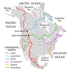
The Atlantic seaboard watershed is a watershed of the Atlantic Ocean in eastern North America along the Atlantic Canada (Maritimes) coast south of the Gulf of Saint Lawrence Watershed, and the East Coast of the United States north of the Kissimmee River watershed of Lake Okeechobee basin in the central Florida Peninsula.
The continental area east of the Appalachian Mountains and highlands to the north and south is demarcated on the south by drainage to the Lake Okeechobee basin (which drains both westward to the Gulf and eastward to ocean), the Eastern Continental Divide (ECD) to the west, and the Saint Lawrence divide to the north. US physiographic regions of this watershed are the Atlantic Plain and the Appalachian Mountains & Highlands.
Sub-watersheds adjacent to the Saint Lawrence divide
Chedabucto Bay: 2,148 square miles (5,560 km2)[1]
Gulf of Maine: 69,115 square miles (179,010 km2)
Long Island Sound: 16,246 square miles (42,080 km2)
Lower New York Bay: >14,000 square miles (36,000 km2)[clarification needed - The 14000 value is just the Hudson River drainage]
Other notable sub-watersheds
Delaware Bay: 14,119 square miles (36,570 km2)[clarification needed - The 14119 value is just the Delaware River drainage] — larger than several, but not adjacent to either divide
Rehoboth Bay
Indian River Bay
Assawoman Bay
Isle of Wight Bay
Sinepuxent Bay
Chincoteague Bay
Chesapeake Bay: 64,299 square miles (166,530 km2) — adjacent to both divides (at the Triple Divide point)
Sub-watersheds adjacent to the Eastern Continental Divide
Albemarle Sound: >14,380 square miles (37,200 km2)[2][specify]
Winyah Bay: >7,221 square miles (18,700 km2)[3][specify]
Santee River: >4,531 square miles (11,740 km2)[4][specify]
Savannah River: 9,850 square miles (25,500 km2)
St. Johns River: 8,840 square miles (22,900 km2)
Biscayne Bay: >2,800 square miles (7,300 km2)[clarification needed - The 2800 value is just the Miami River drainage]
Kissimmee River: 3,000 square miles (7,800 km2)
^"Chedabucto Bay". Archived from the original on 2011-07-06. Retrieved 2010-04-10.
^"Archived copy" (PDF). Archived from the original (PDF) on 2011-07-18. Retrieved 2010-08-10.{{cite web}}: CS1 maint: archived copy as title (link)
^[1][permanent dead link]
^"Bureau of Water -- Outreach". Archived from the original on 2010-06-03. Retrieved 2010-08-10.
and 25 Related for: Atlantic seaboard watershed information
The Atlanticseaboardwatershed is a watershed of the Atlantic Ocean in eastern North America along the Atlantic Canada (Maritimes) coast south of the...
North America that separates the easterly AtlanticSeaboardwatershed from the westerly Gulf of Mexico watershed. The divide nearly spans the United States...
drainage basins or watersheds, each of which drains to a specific ocean, sea or gulf, such as the North American Atlanticseaboardwatershed which is demarcated...
constituent valley of the Great Appalachian Valley, within the AtlanticSeaboardwatershed in Pennsylvania and Maryland. The Appalachian Trail crosses through...
(secondary coordinates) The AtlanticSeaboard Fall Line, or Fall Zone, is a 900-mile (1,400 km) escarpment where the Piedmont and Atlantic coastal plain meet in...
media related to Rivers of Virginia. Rivers portal AtlanticSeaboard Fall Line Atlanticseaboardwatershed Chesapeake Bay Chesapeake Bay Program Chesapeake...
basins spanning three oceans (Arctic, Atlantic and Pacific) and one endorheic basin. The basins are the AtlanticSeaboard basin, the Gulf of Mexico basin,...
In North America, they are commonly called a watershed, though in other English-speaking places, "watershed" is used only in its original sense, that of...
Bay watershed, on the Labrador Sea and Gulf of St. Lawrence, in the St. Lawrence River watershed (including the Great Lakes), and on the Atlantic seaboard...
Piedmont Plateau, and the Atlantic coastal plain. Once the Potomac drops from the Piedmont to the Coastal Plain at the AtlanticSeaboard fall line at Little...
approached. Floodwaters inundated communities and roadways along the Atlanticseaboard from North Carolina to New Jersey. The highest storm surge was 3.67 ft...
AtlanticSeaboard, to over 22 °C (72 °F) in False Bay. Average annual ocean surface temperatures are between 13 °C (55 °F) on the AtlanticSeaboard (similar...
scenic, lacking the sandy beaches found to the south along the Eastern Seaboard. The only significant coastal developments are located in the Boston, Portsmouth...
in 1825, the lake was part of an important waterway connecting the Atlanticseaboard of North America to the continental interior. The lake is about 21...
Fund, applying that term to an analysis of the urbanized northeastern seaboard of the U.S. spanning from Boston in the north to Washington, D.C. in the...
Lehigh River joins the Delaware. At Trenton, the Delaware crosses the AtlanticSeaboard Fall Line with a drop of 8 feet (2.4 m). Below Trenton, the Delaware...
region: including the Appalachian Mountains, the coastal plain of the AtlanticSeaboard, and the Florida peninsula. Mexico and its long plateaus and cordilleras...
Richelieu, Hudson, Mohawk and Susquehanna form an arc of watersheds east to the Atlantic. The Great Lakes region, as distinct from the Great Lakes Basin...
Florentine explorer Giovanni da Verrazzano sailed north along the Atlanticseaboard and into New York Harbor, however he left the harbor shortly thereafter...
funnelled to Montreal, New York City, and other locations on the Eastern Seaboard. By the night of June 6, New York City had the worst air pollution of any...
Delaware Bay is the estuary outlet of the Delaware River on the northeast seaboard of the United States, lying between the states of Delaware and New Jersey...
the Gulf of Mexico PDF version, 48 KB Armand Bayou Watershed Working Group, The Texas Coastal Watershed Program, Houston Texas. Aronow, S., ndb, Geomorphology...
000 ha) Okefenokee, sending volumes of smoke across the southern Atlanticseaboard and with an unknown impact on wildlife. With the drought still continuing...
France was defeated and its colonies were seized by Britain. On the eastern seaboard, the four distinct English regions were New England, the Middle Colonies...
Fort Rouillé in 1750. As the easternmost and nearest lake to the Atlanticseaboard of Canada and the United States, population centres here are among...
 Global Information