Little Falls, near Washington, D.C. (non-tidal; water years: 1931–2018)[2]
• average
11,498 cu ft/s (325.6 m3/s) (1931–2018)
• minimum
4,017 cu ft/s (113.7 m3/s) (2002)
• maximum
484,000 cu ft/s (13,700 m3/s) (1936)
Discharge
• location
Point of Rocks, Maryland
• average
9,504 cu ft/s (269.1 m3/s)
Discharge
• location
Hancock, Maryland
• average
4,168 cu ft/s (118.0 m3/s)
Discharge
• location
Paw Paw, West Virginia
• average
3,376 cu ft/s (95.6 m3/s)
Basin features
Tributaries
• left
Conococheague Creek, Antietam Creek, Monocacy River, Rock Creek, Anacostia River
• right
Cacapon River, Shenandoah River, Goose Creek, Occoquan River, Wicomico River
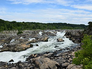
Waterfalls
Great Falls, Little Falls
------------------------------------------------------------------ Note: Since 1996, the Potomac has been the 'sister river' of the Ara River of Tokyo, Japan[3]
The Potomac River (/pəˈtoʊmək/ⓘ) is a major river in the Mid-Atlantic region of the United States that flows from the Potomac Highlands in West Virginia to the Chesapeake Bay in Maryland. It is 405 miles (652 km) long,[4] with a drainage area of 14,700 square miles (38,000 km2),[5] and is the fourth-largest river along the East Coast of the United States and the 21st-largest in the United States. More than 5 million people live within its watershed.
The river forms part of the borders between Maryland and Washington, D.C., on the left descending bank, and West Virginia and Virginia on the right descending bank. Except for a small portion of its headwaters in West Virginia, the North Branch Potomac River is considered part of Maryland to the low-water mark on the opposite bank. The South Branch Potomac River lies completely within the state of West Virginia except for its headwaters, which lie in Virginia.
^"President Clinton: Celebrating America's Rivers". American Heritage Rivers. July 30, 1998. Archived from the original on April 28, 2014. Retrieved February 5, 2014.
^"USGS 01646500 POTOMAC RIVER NEAR WASH, DC LITTLE FALLS PUMP STA". nwis.waterdata.usgs.gov. National Weather Service (NOAA). 2019. Archived from the original on October 28, 2020. Retrieved March 23, 2019.
^"(Arakawa - Potomac sister rivers)". Interstate Commission on the Potomac River Basin. January 27, 2012. Archived from the original on December 27, 2013. Retrieved September 23, 2016.
^U.S. Geological Survey. National Hydrography Dataset high-resolution flowline data. The National Map Archived March 29, 2012, at the Wayback Machine. Retrieved August 15, 2011
^"Facts & FAQs". Interstate Commission on the Potomac River Basin (ICPRB), Rockville, MD. September 16, 2009. Archived from the original on January 15, 2010. Retrieved February 5, 2010.
The PotomacRiver (/pəˈtoʊmək/ ) is a major river in the Mid-Atlantic region of the United States that flows from the Potomac Highlands in West Virginia...
The PotomacRiver Rapist refers to a serial rapist and murderer who was active in the Washington, D.C. metropolitan area from 1991 to 1998. Ten sexual...
The South Branch PotomacRiver has its headwaters in northwestern Highland County, Virginia, near Hightown along the eastern edge of the Allegheny Front...
This is a list of bridges and other crossings of the PotomacRiver and its North and South branches. Within each section, crossings are listed from the...
Chesapeake Bay Wicomico River (PotomacRiver), a tributary of the PotomacRiver in south central Maryland Great Wicomico River, a tributary of Chesapeake...
Little Patuxent River Middle Patuxent River Hawlings RiverPotomacRiver St. Marys River St. George Creek Difficult Run Wicomico River Budds Creek Popes...
Look up Potomac in Wiktionary, the free dictionary. Potomac (listen) may refer to: Washington, D.C. area: The PotomacRiver, which flows through West...
States Department of Defense, in Arlington County, Virginia, across the PotomacRiver from Washington, D.C. The building was constructed on an accelerated...
737-222 registered as N62AF crashed into the 14th Street Bridge over the PotomacRiver just after take off from Washington National Airport. Striking the bridge...
The North Branch PotomacRiver flows from Fairfax Stone in West Virginia to its confluence with the South Branch PotomacRiver near Green Spring, West...
The Shenandoah River /ˌʃɛnənˈdoʊə/ is the principal tributary of the PotomacRiver, 55.6 miles (89.5 km) long with two forks approximately 100 miles (160 km)...
the PotomacRiver which was created in the 19th century, an inlet that links the Potomac with the northern end of the Washington Channel. West Potomac Park...
counties (Grant, Hampshire, Hardy, Mineral, and Pendleton) in the upper PotomacRiver watershed in the western portion of the state's Eastern Panhandle, bordering...
The region occupied by the Powhatan was bounded approximately by the PotomacRiver to the north, the Fall Line to the west, the Virginia-North Carolina...
The Potomac Company (spelled variously as Patowmack, Potowmack, Potowmac, and Compony) was created in 1785 to make improvements to the PotomacRiver and...
This is a list of cities, towns, and communities along the PotomacRiver and its branches in the United States. Alexandria, Virginia Arlington, Virginia...
Machipongo River Pocomoke RiverPotomacRiver Hull Creek Coan River Yeocomico River Northwest Yeocomico River South Yeocomico River West Yeocomico River Lower...
simply DCA, is a civil airport in Arlington County, Virginia, across the PotomacRiver from Washington, D.C. It is the 23rd-busiest airport in the nation and...
East Potomac Park is a park located on a man-made island in the PotomacRiver in Washington, D.C., United States. The island is between the Washington...
it joins with the Washington Channel and ultimately empties into the PotomacRiver at Buzzard Point. It is about 8.7 miles (14.0 km) long. The name "Anacostia"...
bridges refers to the three bridges near each other that cross the PotomacRiver, connecting Arlington, Virginia and Washington, D.C. Sometimes the two...
 Global Information