Global Information Lookup Global Information

Atlantic Seaboard Fall Line information


Atlantic Seaboard fall line
Escarpment
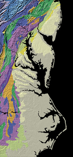
Map showing part of the Eastern Seaboard Fall Line where the pale-colored coastal plain meets the brightly-colored Piedmont.
LocationUnited States
Formed byNew Jersey
Virginia
Carolinas or Georgia[1][2]
Dimensions
 • Length900 mi (1,400 km)[2]

The Atlantic Seaboard Fall Line, or Fall Zone, is a 900-mile (1,400 km) escarpment where the Piedmont and Atlantic coastal plain meet in the eastern United States.[2] Much of the Atlantic Seaboard fall line passes through areas where no evidence of faulting is present.

The fall line marks the geologic boundary of hard metamorphosed terrain—the product of the Taconic orogeny—and the sandy, relatively flat alluvial plain of the upper continental shelf, formed of unconsolidated Cretaceous and Cenozoic sediments. Examples of Fall Zone features include the Potomac River's Little Falls and the rapids in Richmond, Virginia, where the James River falls across a series of rapids down to its own tidal estuary.

Before navigation improvements such as locks, the fall line was generally the head of navigation on rivers due to their rapids or waterfalls, and the necessary portage around them. Numerous cities initially formed along the fall line because of the easy river transportation to seaports, as well the availability of water power to operate mills and factories, thus bringing together river traffic and industrial labor. U.S. Route 1 and I-95 link many of the fall-line cities.

In 1808, Treasury Secretary Albert Gallatin noted the significance of the fall line as an obstacle to improved national communication and commerce between the Atlantic seaboard and the western river systems:[3]

The most prominent, though not perhaps the most insuperable obstacle in the navigation of the Atlantic rivers, consists in their lower falls, which are ascribed to a presumed continuous granite ridge, rising about one hundred and thirty feet above tide water. That ridge from New York to James River inclusively arrests the ascent of the tide; the falls of every river within that space being precisely at the head of the tide; pursuing thence southwardly a direction nearly parallel to the mountains, it recedes from the sea, leaving in each southern river an extent of good navigation between the tide and the falls. Other falls of less magnitude are found at the gaps of the Blue Ridge, through which the rivers have forced their passage...

  1. ^ "The Fall Line". A Tapestry of Time and Terrain: The Union of Two Maps - Geology and Topography. USGS.gov. Archived from the original on 2011-05-14. Retrieved 2010-08-12. An alternate source claims the southern endpoint is farther west because there are "waterfalls & rapids":
    "Georgia Geology". Archived from the original on 4 September 2010. Retrieved 2010-08-13.
  2. ^ a b c Freitag, Bob; Susan Bolton; Frank Westerlund; Julie Clark (2009). Floodplain Management: A New Approach for a New Era. Island Press. p. 77. ISBN 978-1-59726-635-2. Retrieved 17 November 2010.
  3. ^ [Report on] Roads and Canals, Communicated to the Senate April 4, 1808, p.729

and 15 Related for: Atlantic Seaboard Fall Line information

Request time (Page generated in 0.9183 seconds.)

Atlantic Seaboard Fall Line

Last Update:

(secondary coordinates) The Atlantic Seaboard Fall Line, or Fall Zone, is a 900-mile (1,400 km) escarpment where the Piedmont and Atlantic coastal plain meet in...

Word Count : 972

Fall line

Last Update:

coordinates) The Atlantic Seaboard Fall Line, or Fall Zone, is a 1,400-kilometre (900-mile) escarpment where the Piedmont and Atlantic Coastal Plain meet...

Word Count : 959

East Coast of the United States

Last Update:

Seaboard, the Atlantic Coast, and the Atlantic Seaboard, is the region encompassing the coastline where the Eastern United States meets the Atlantic Ocean...

Word Count : 2230

List of Chesapeake Bay rivers

Last Update:

larger rivers cross the Atlantic seaboard fall line. Over time, many large cities emerged where these rivers cross the fall line as watermills allowed for...

Word Count : 865

Seaboard Air Line Railroad

Last Update:

1, 1967, when it merged with the Atlantic Coast Line Railroad, its longtime rival, to form the Seaboard Coast Line Railroad. Predecessor railroads dated...

Word Count : 7506

Potomac River

Last Update:

Plateau, and the Atlantic coastal plain. Once the Potomac drops from the Piedmont to the Coastal Plain at the Atlantic Seaboard fall line at Little Falls...

Word Count : 6049

South Carolina

Last Update:

rice plantations in the South Carolina Lowcountry, east of the Atlantic Seaboard fall line. Plantation labor was done by African slaves who formed the majority...

Word Count : 11852

Escarpment

Last Update:

Klint South Småland-Sub-Cambrian escarpment Malta Victoria Lines Atlantic Seaboard Fall Line Florida Escarpment, Gulf of Mexico Sigsbee Escarpment, Gulf of...

Word Count : 907

Subregion

Last Update:

and West Texas in this subregion) by physiography: Atlantic coastal plain Atlantic Seaboard Fall Line East Coast of the United States Great Basin Great...

Word Count : 3020

Eastern Continental Divide

Last Update:

hydrological divide in eastern North America that separates the easterly Atlantic Seaboard watershed from the westerly Gulf of Mexico watershed. The divide nearly...

Word Count : 1383

Powhatan

Last Update:

Potomac River to the north, the Fall Line to the west, the Virginia-North Carolina border to the south, and the Atlantic Ocean to the east. Generally peaceful...

Word Count : 5500

Kaolinite

Last Update:

kaolin deposits are found in central Georgia, on a stretch of the Atlantic Seaboard fall line between Augusta and Macon. This area of thirteen counties is...

Word Count : 5470

North Carolina

Last Update:

The coastal plain transitions to the Piedmont region along the Atlantic Seaboard fall line, the elevation at which waterfalls first appear on streams and...

Word Count : 19256

Philadelphia

Last Update:

N, 75.20747 W. Philadelphia is located on the Atlantic Seaboard Fall Line that separates the Atlantic Plain from the Piedmont. The Schuylkill River's...

Word Count : 23179

Delaware

Last Update:

The Atlantic Seaboard fall line approximately follows the Robert Kirkwood Highway between Newark and Wilmington; south of this road is the Atlantic Coastal...

Word Count : 13123

PDF Search Engine © AllGlobal.net