Elliptical depressions concentrated along the Atlantic seaboard of North America
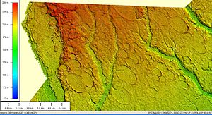
LIDAR elevation image of 300 square miles (800 km2) of Carolina bays in Robeson County, North Carolina
Carolina bays are elliptical to circular depressions concentrated along the East Coast of the United States within coastal New York, New Jersey, Delaware, Maryland, Virginia, North Carolina, South Carolina, Georgia, and north Florida.[1][2][3] In Maryland, they are called Maryland basins.[4] Within the Delmarva Peninsula, they and other coastal ponds are also called Delmarva bays.[5]
The name "Carolina bay" is sometimes attributed to the writings of the English explorer John Lawson who explored North Carolina, South Carolina, and Georgia during the early 18th century. This attribution, however, is not correct. Lawson described visiting a swamp that contained bay trees, but there is no indication that he wanted to name the swamp with the word "bay".[6] Furthermore, Lawson said that this swamp had steep margins and that he could see mountains to the west from the vicinity of the swamp. Thus, it seems more likely that this swamp was an inter-dune depression among the Carolina Sandhills, rather than a Carolina bay. Nevertheless, bay trees are present in some Carolina bays.[7]
The earliest scientific description of Carolina bays is by Glenn (1895), who used the term 'bay' (which he described as "lake-like expanses") to refer to these features near the town of Darlington, South Carolina.[8] Glenn (1895) put quotation marks around the word "bay" but he did not use the phrase "Carolina bay." A subsequent publication by Melton and Schriever (1933) used the phrase: The Carolina "Bays" (with quotation marks around the word "Bays").[9] Later, MacCarthy (1937) published a paper entitled "The Carolina Bays" and he used this phrase throughout the publication (without quotation marks, and with a capital "B" for the word "Bays").[10]
^Cite error: The named reference Prouty1952a was invoked but never defined (see the help page).
^Kaczorowski, R. T. (1977) The Carolina Bays: a Comparison with Modern Oriented Lakes Technical Report no. 13-CRD, Coastal research Division, Department of Geology, University of South Carolina, Columbia.
^Gill, Gloria (24 March 2013). "Occurrence of Carolina Bays on Long Island" (PDF). SUNY.
^Cite error: The named reference RasmussenOthers1955a was invoked but never defined (see the help page).
^Coleman, D. (2001) Delmarva Bays: Natural Enigmas. Archived 2008-09-16 at the Wayback Machine Maryland Department of Natural Resources Archived September 3, 2013, at the Wayback Machine, Annapolis. Maryland.
^Lawson, J., A New Voyage to Carolina[ISBN missing][page needed]
^Sharitz, Rebecca R. (2003). "Carolina bay wetlands: Unique habitats of the southeastern United States". Wetlands. 23 (3): 550. doi:10.1672/0277-5212(2003)023[0550:CBWUHO]2.0.CO;2. ISSN 0277-5212. S2CID 19954348.
^Glenn, L. C. (1895). "Some Notes on Darlington (S. C.), 'Bays.'". Science. 2 (41): 472–475. Bibcode:1895Sci.....2..472G. doi:10.1126/science.2.41.472. PMID 17796996.
^Melton, F. A.; Schriever, William (1933). "The Carolina 'Bays': Are They Meteorite Scars?". The Journal of Geology. 41 (1): 52–66. Bibcode:1933JG.....41...52M. doi:10.1086/624004. S2CID 140175406.
^Maccarthy, G. R. (1937). "The Carolina Bays". Geological Society of America Bulletin. 48 (9): 1211–1225. Bibcode:1937GSAB...48.1211M. doi:10.1130/GSAB-48-1211. S2CID 130189967.
phrase: The Carolina "Bays" (with quotation marks around the word "Bays"). Later, MacCarthy (1937) published a paper entitled "The CarolinaBays" and he used...
South Carolina Highway 31 (SC 31), also known as the CarolinaBays Parkway, is a 28.097-mile (45.218 km) six-lane, limited-access highway that parallels...
North Carolina. Lake Waccamaw is the largest of the Carolinabays. While large, natural lakes are rare in North Carolina, excepting the Carolinabays in...
is a large number of low-relief topographic depressions named Carolinabays. The bays tend to be oval, lining up in a northwest to southeast orientation...
shock wave that gouged out the CarolinaBays and reset the radiocarbon clock. Most geologists today interpret the Carolinabays as relict geomorphological...
and mostly exists in pine/blackjack oak forests on sandhills, rims of Carolinabays, dunes, dry pastures, fields and roadsides. The green leaves of this...
spring months, and drying out in the summer. CarolinaBays often contain rare species, some endemic to the bays. Freshwater organisms are generally divided...
west on the proposed extension of South Carolina Highway 31 (SC 31; CarolinaBays Parkway) into South Carolina. This entire section of I-74 is still under...
what Carolinabays looked like also shows Tuckahoe Bay, when it was undisturbed. Even as current development is abundant around the area, the bay has remained...
the northeast. Popigai impact structure of similar age Grande Coupure Carolinabays Schmitz, Birger; Boschi, Samuele; Cronholm, Anders; Heck, Philipp R...
CarolinaBays, the term "bay" does not refer to the trees but comes instead from an early science publication by Glenn (1895), who used the word "bay"...
to Interstate 74 at OpenStreetMap I-74 in NC Progress Page SCDOT - CarolinaBays Parkway Phase II (part of I-74) High Priority Corridor 5 (I-73/74) Archived...
bodies of water in the state's Coastal Plain. Most of the lakes are CarolinaBays. The NC Division of Parks & Recreation describes its State Lakes as...
an important component of the ecosystem include the CarolinaBays, the sandhills of the Carolinas, and elsewhere, Mulga scrub in Australia, and the xeric...
connects with North Carolina Bicycle Route 3, the Ports of Call Route. Rolling hills soon give way to flat land in the swamps and Carolinabays typical of this...
the Atlantic Ocean in South Carolina, United States, extending more than 60 miles (97 km) from Little River to Winyah Bay. It is located in Horry and...
of the largest Carolinabays. Singletary Lake State Park is southeast of Elizabethtown on North Carolina Highway 53 in North Carolina's Coastal Plain region...
Tarpon Bay or Tarpon Bayou may refer to any of several bays in Florida and South Carolina, named for the tarpon fish: Tarpon Bay of Sanibel Island, Florida...
of the year. In South Carolina's lower Coastal Plain, loblolly-bay is found in wet flats and in bays, typically the CarolinaBays (11). In the upper and...
coastal lands of low relief that are pockmarked with Carolinabays. Down river from Dillon, South Carolina is Little Pee Dee State Park. Adjacent to this is...
northwesterly, crossing the proposed routing of I-74 (currently SC 31, the CarolinaBays Parkway). After passing Conway, I-73 will leave SC 22 at a new interchange...
worked on projects in Florida, Texas, Louisiana, and the Carolinas, such as the CarolinaBays Parkway project. In 2005, Flatiron began working in Western...
the shores of Lake Waccamaw, a Carolinabay. Recent work by the U.S. Geological Survey has interpreted the CarolinaBays as relict thermokarst lakes that...
Plain. Recent work by the U.S. Geological Survey has interpreted the CarolinaBays as relict thermokarst lakes that formed several thousands of years ago...
Coastal Plain that are called CarolinaBays. Recent work by the U.S. Geological Survey has interpreted the CarolinaBays as relict thermokarst lakes that...
 Global Information