 Global Information
Delaware River information
| Delaware River | |
|---|---|
 The Delaware River flowing through the Delaware Water Gap in 2021 | |
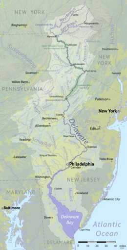 Map of the Delaware River watershed, showing major tributaries and cities | |
| Location | |
| Country | United States |
| State | New York, New Jersey, Pennsylvania, Delaware and Maryland |
| Cities | Margaretville, NY, Delhi, NY, Deposit, NY, Hancock, NY, Callicoon, NY, Lackawaxen, PA, Port Jervis, NY, Stroudsburg, PA, Easton, PA, New Hope, PA, Trenton, NJ, Camden, NJ, Philadelphia, PA, Chester, PA, Wilmington, DE, Salem, NJ, Dover, DE |
| Physical characteristics | |
| Source | West Branch |
| • location | Mount Jefferson, Town of Jefferson, Schoharie County, New York, United States |
| • coordinates | 42°27′12″N 74°36′26″W / 42.45333°N 74.60722°W |
| • elevation | 2,240 ft (680 m) |
| 2nd source | East Branch |
| • location | Grand Gorge, Town of Roxbury, Delaware County, New York, United States |
| • coordinates | 42°21′26″N 74°30′42″W / 42.35722°N 74.51167°W |
| • elevation | 1,560 ft (480 m) |
| Source confluence | |
| • location | Town of Hancock, Delaware County, New York, United States |
| • coordinates | 41°56′20″N 75°16′46″W / 41.93889°N 75.27944°W |
| • elevation | 880 ft (270 m) |
| Mouth | Delaware Bay |
• location | Delaware, United States |
• coordinates | 39°25′13″N 75°31′11″W / 39.42028°N 75.51972°W |
• elevation | 0 ft (0 m) |
| Length | 301 mi (484 km) |
| Basin size | 13,539 sq mi (35,070 km2) |
| Discharge | |
| • location | Trenton |
| • average | 12,100 cu ft/s (340 m3/s) |
| • minimum | 4,310 cu ft/s (122 m3/s) |
| • maximum | 329,000 cu ft/s (9,300 m3/s) |
| Discharge | |
| • location | Port Jervis |
| • average | 7,900 cu ft/s (220 m3/s) |
| • minimum | 1,420 cu ft/s (40 m3/s) |
| • maximum | 52,900 cu ft/s (1,500 m3/s) |
| Basin features | |
| Tributaries | |
| • left | Neversink River, Pequest River, Musconetcong River |
| • right | Lehigh River, Schuylkill River, Christina River |
National Wild and Scenic River | |
| Type | Scenic, Recreational |
Delaware River | |||||||||||||||||||||||||||||||||||||||||||||||||||||||||||||||||||||||||||||||||||||||||||||||||||||||||||||||||||||||||||||||||||||||||||||||||||||||||||||||||||||||||||||||||||||||||||||||||||||||||||||||||||||||||||||||||||||||||||||||||||||||||||||||||||||||||||||||||||||||||||||||||||||||||||||||||||||||||||||||||||||||||||||||||||||||||||||||||||||||||||||||||||||||||||||||||||||||||||||||||||||||||||||||||||||||||||||||||||||||||||||||||||||||||||||||||||||||||||||||||||||||||||||||||||||||||||||||||||||||||||||||||||||||||||||||||||||||||||||||||||||||||||||||||||||||||||||||||||||||||||||||||||||||||||||||||||||||||||||||||||||||||||||||||||||||||||||||||||||||||||||||||||||||||||||||||||||||||||||||||||||||||||||||||||||||||||||||||||||||||||||||||||||||||||||||||||||||||||||||||||||||||||||||||||||||||||||||||||||||||||||||||||||||||||||||||||||||||||||||||||||||||||||||||||||||||||||||||||||||||||||||||||||||||||||||||||||||||||||||||||||||||||||||||||||||||||||||||||||||
|---|---|---|---|---|---|---|---|---|---|---|---|---|---|---|---|---|---|---|---|---|---|---|---|---|---|---|---|---|---|---|---|---|---|---|---|---|---|---|---|---|---|---|---|---|---|---|---|---|---|---|---|---|---|---|---|---|---|---|---|---|---|---|---|---|---|---|---|---|---|---|---|---|---|---|---|---|---|---|---|---|---|---|---|---|---|---|---|---|---|---|---|---|---|---|---|---|---|---|---|---|---|---|---|---|---|---|---|---|---|---|---|---|---|---|---|---|---|---|---|---|---|---|---|---|---|---|---|---|---|---|---|---|---|---|---|---|---|---|---|---|---|---|---|---|---|---|---|---|---|---|---|---|---|---|---|---|---|---|---|---|---|---|---|---|---|---|---|---|---|---|---|---|---|---|---|---|---|---|---|---|---|---|---|---|---|---|---|---|---|---|---|---|---|---|---|---|---|---|---|---|---|---|---|---|---|---|---|---|---|---|---|---|---|---|---|---|---|---|---|---|---|---|---|---|---|---|---|---|---|---|---|---|---|---|---|---|---|---|---|---|---|---|---|---|---|---|---|---|---|---|---|---|---|---|---|---|---|---|---|---|---|---|---|---|---|---|---|---|---|---|---|---|---|---|---|---|---|---|---|---|---|---|---|---|---|---|---|---|---|---|---|---|---|---|---|---|---|---|---|---|---|---|---|---|---|---|---|---|---|---|---|---|---|---|---|---|---|---|---|---|---|---|---|---|---|---|---|---|---|---|---|---|---|---|---|---|---|---|---|---|---|---|---|---|---|---|---|---|---|---|---|---|---|---|---|---|---|---|---|---|---|---|---|---|---|---|---|---|---|---|---|---|---|---|---|---|---|---|---|---|---|---|---|---|---|---|---|---|---|---|---|---|---|---|---|---|---|---|---|---|---|---|---|---|---|---|---|---|---|---|---|---|---|---|---|---|---|---|---|---|---|---|---|---|---|---|---|---|---|---|---|---|---|---|---|---|---|---|---|---|---|---|---|---|---|---|---|---|---|---|---|---|---|---|---|---|---|---|---|---|---|---|---|---|---|---|---|---|---|---|---|---|---|---|---|---|---|---|---|---|---|---|---|---|---|---|---|---|---|---|---|---|---|---|---|---|---|---|---|---|---|---|---|---|---|---|---|---|---|---|---|---|---|---|---|---|---|---|---|---|---|---|---|---|---|---|---|---|---|---|---|---|---|---|---|---|---|---|---|---|---|---|---|---|---|---|---|---|---|---|---|---|---|---|---|---|---|---|---|---|---|---|---|---|---|---|---|---|---|---|---|---|---|---|---|---|---|---|---|---|---|---|---|---|---|---|---|---|---|---|---|---|---|---|---|---|---|---|---|---|---|---|---|---|---|---|---|---|---|---|---|---|---|---|---|---|---|---|---|---|---|---|---|---|---|---|---|---|---|---|---|---|---|---|---|---|---|---|---|---|---|---|---|---|---|---|---|---|---|---|---|---|---|---|---|---|---|---|---|---|---|---|---|---|---|---|---|---|---|---|---|---|---|---|---|---|---|---|---|---|---|---|---|---|---|---|---|---|---|---|---|---|---|---|---|---|---|---|---|---|---|---|---|---|---|---|---|---|---|---|---|---|---|---|---|---|---|---|---|---|---|---|---|---|---|---|---|---|---|---|---|---|---|---|---|---|---|---|---|---|---|---|---|---|---|---|---|---|---|---|---|---|---|---|---|---|---|---|---|---|---|---|---|---|---|---|---|---|---|---|---|---|---|---|---|---|---|---|---|---|---|---|---|---|---|---|---|---|---|---|---|---|---|---|---|---|---|---|---|---|---|---|---|---|---|---|---|---|---|---|---|---|---|---|---|---|---|---|---|---|---|---|---|---|---|---|---|---|---|---|---|---|---|---|---|---|---|---|---|---|---|---|---|---|---|---|---|---|---|---|---|---|---|---|---|---|---|---|---|---|---|---|---|---|---|---|---|---|---|---|---|---|---|---|---|---|---|---|---|---|---|---|---|---|---|---|---|---|---|---|---|---|---|---|---|---|---|---|---|---|---|---|---|---|---|---|---|---|---|---|---|---|---|---|---|---|---|---|---|---|---|---|---|---|---|---|---|---|---|---|---|---|---|---|---|---|---|---|---|---|---|---|---|---|---|---|---|---|---|---|---|---|---|---|---|---|---|---|---|---|---|---|---|---|---|---|---|---|---|---|---|---|---|---|---|---|---|---|---|---|---|---|---|---|---|---|---|---|---|---|---|---|---|---|---|---|---|---|---|
| |||||||||||||||||||||||||||||||||||||||||||||||||||||||||||||||||||||||||||||||||||||||||||||||||||||||||||||||||||||||||||||||||||||||||||||||||||||||||||||||||||||||||||||||||||||||||||||||||||||||||||||||||||||||||||||||||||||||||||||||||||||||||||||||||||||||||||||||||||||||||||||||||||||||||||||||||||||||||||||||||||||||||||||||||||||||||||||||||||||||||||||||||||||||||||||||||||||||||||||||||||||||||||||||||||||||||||||||||||||||||||||||||||||||||||||||||||||||||||||||||||||||||||||||||||||||||||||||||||||||||||||||||||||||||||||||||||||||||||||||||||||||||||||||||||||||||||||||||||||||||||||||||||||||||||||||||||||||||||||||||||||||||||||||||||||||||||||||||||||||||||||||||||||||||||||||||||||||||||||||||||||||||||||||||||||||||||||||||||||||||||||||||||||||||||||||||||||||||||||||||||||||||||||||||||||||||||||||||||||||||||||||||||||||||||||||||||||||||||||||||||||||||||||||||||||||||||||||||||||||||||||||||||||||||||||||||||||||||||||||||||||||||||||||||||||||||||||||||||||||
The Delaware River is a major river in the Mid-Atlantic region of the United States and is the longest free-flowing (undammed) river in the Eastern United States. From the meeting of its branches in Hancock, New York, the river flows for 282 miles (454 km)[1] along the borders of New York, Pennsylvania, New Jersey, and Delaware, before emptying into Delaware Bay.
The river has been recognized by the National Wildlife Federation as one of the country's Great Waters[2] and has been called the "Lifeblood of the Northeast" by American Rivers.[3] Its watershed drains an area of 13,539 square miles (35,070 km2) and provides drinking water for 17 million people, including half of New York City via the Delaware Aqueduct.
The Delaware River has two branches that rise in the Catskill Mountains of New York: the West Branch at Mount Jefferson in Jefferson, Schoharie County, and the East Branch at Grand Gorge, Delaware County. The branches merge to form the main Delaware River at Hancock, New York. Flowing south, the river remains relatively undeveloped, with 152 miles (245 km) protected as the Upper, Middle, and Lower Delaware National Scenic Rivers.[4] At Trenton, New Jersey, the Delaware becomes tidal, navigable, and significantly more industrial. This section forms the backbone of the Delaware Valley metropolitan area, serving the port cities of Philadelphia, Camden, New Jersey, and Wilmington, Delaware. The river flows into Delaware Bay at Liston Point, 48 miles (77 km)[1] upstream of the bay's outlet to the Atlantic Ocean between Cape May and Cape Henlopen.
Before the arrival of European settlers, the river was the homeland of the Lenape native people. They called the river Lenapewihittuk, or Lenape River, and Kithanne, meaning the largest river in this part of the country.[5]
In 1609, the river was visited by a Dutch East India Company expedition led by Henry Hudson. Hudson, an English navigator, was hired to find a western route to Cathay (China), but his encounters set the stage for Dutch colonization of North America in the 17th century. Early Dutch and Swedish settlements were established along the lower section of the river and Delaware Bay. Both colonial powers called the river the South River (Zuidrivier), compared to the Hudson River, which was known as the North River. After the English expelled the Dutch and took control of the New Netherland colony in 1664, the river was renamed Delaware after Sir Thomas West, 3rd Baron De La Warr, an English nobleman and the Virginia colony's first royal governor, who defended the colony during the First Anglo-Powhatan War. George Washington's crossing of the Delaware River in 1776 led to the Americans winning the Battle of Trenton, which was a pivotal moment in the American Revolution.
- ^ a b "DRB river-mileage spreadsheet" (PDF). River Mileage System. Delaware River Basin Commission. Retrieved October 24, 2022.
- ^ National Wildlife Federation (August 18, 2010). "America's Great Waters Coalition". Archived from the original on August 15, 2011. Retrieved August 18, 2011.
- ^ "Delaware River". www.americanrivers.org. American Rivers. Retrieved March 23, 2023.
- ^ "National Wild and Scenic Rivers in the DRB". nj.gov. Delaware River Basin Commission. Retrieved October 24, 2022.
- ^ Heckewelder, John; Du Ponceau, Peter S. (1834), "Names which the Lenni Lenape or Delaware Indians, who once inhabited this country, had given to Rivers, Streams, Places, &c.", Transactions of the American Philosophical Society, 4: 351–396, doi:10.2307/1004837, JSTOR 1004837