Global Information Lookup Global Information

Witwatersrand information


Witwatersrand
Witpoortjie Falls in the Walter Sisulu National Botanical Garden, formerly the Witwatersrand National Botanical Gardens. Waterfalls like this, cascading over a 56-kilometre-long (35 mi) quartzite ridge in Gauteng gave rise to the name “Witwatersrand”, which means “white water ridge” in Afrikaans.
Highest point
Elevation1,913 m (6,276 ft)
Coordinates26°12′13″S 28°2′34″E / 26.20361°S 28.04278°E / -26.20361; 28.04278
Dimensions
Length56 km (35 mi) ESE/WNW
Width10 km (6.2 mi) NNE/SSW
Geography
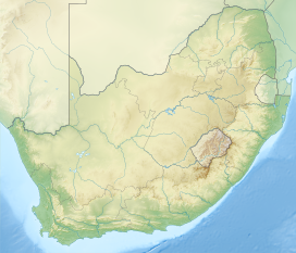
Witwatersrand is located in South Africa
Witwatersrand
Witwatersrand
CountrySouth Africa
ProvincesNorth West, Gauteng and Mpumalanga
Geology
OrogenyVredefort impact structure
Age of rockArchean
Type of rockQuartzites, conglomerates, banded ironstones, tillites and shales
Climbing
Easiest routeFrom Gauteng or Pretoria

The Witwatersrand (UK: /wɪtˈwɔːtərzrænd, -rɑːnd/, US also /ˈwɪtwɔːtərz-/;[1] Afrikaans pronunciation: [ˌvətˌvɑːtəɾsˈɾant]; locally the Rand or, less commonly, the Reef) is a 56-kilometre-long (35 mi), north-facing scarp in South Africa. It consists of a hard, erosion-resistant quartzite metamorphic rock, over which several north-flowing rivers form waterfalls, which account for the name Witwatersrand, meaning "white water ridge" in Afrikaans.[2] This east-west-running scarp can be traced with only one short gap, from Bedfordview (about 10 km [6 mi] west of O.R. Tambo International Airport) in the east, through Johannesburg and Roodepoort, to Krugersdorp in the west (see the diagram at left below).[3]

The scarp forms the northern edge of a 7-to-10-kilometre-wide (4–6 mi) plateau (or ridge) which rises about 200 m (660 ft) above the surrounding plains of the Highveld. A number of picturesque Johannesburg suburbs, including Observatory, Linksfield Ridge and Upper Houghton are located along the scarp, overlooking the rest of northern Johannesburg with views up to the Magaliesburg[4] (although locals refer to segments of the scarp using area-specific names, such as Linksfield Ridge, Parktown Ridge or Observatory Ridge).[5][6] The entire plateau-like structure is also often called the Witwatersrand. The plateau's elevation above sea-level is between 1,700 and 1,800 metres (5,600–5,900 ft).

The Witwatersrand plateau forms a continental divide, with the run-off to the north draining into the Indian Ocean via the Crocodile and Limpopo rivers, while the run-off to the south drains via the Vaal into the Orange River and ultimately into the Atlantic Ocean.[3][7][8]

Because of the extraordinary quantities of gold that have been extracted from the Witwatersrand rocks, the South African currency was named the rand in 1961 upon the declaration of the republic.

Witwatersrand and the Rand are names for the conurbation that developed along the range, although the terms are falling into disuse[citation needed] and Witwatersrand was the "W" in PWV (Pretoria-Witwatersrand-Vereeniging), the initial name of Gauteng province. In this context, it has lent its name to institutions including the University of the Witwatersrand (Wits University) and the defunct Rand Afrikaans University (RAU, now part of the University of Johannesburg), and to towns and regions such as the East Rand, West Rand and Randburg.

  1. ^ Wells, John C. (2008). Longman Pronunciation Dictionary (3rd ed.). Longman. ISBN 978-1-4058-8118-0.
  2. ^ Truswell, J.F. (1977). The Geological Evolution of South Africa. pp. 21, 27–28, 33–36. Cape Town: Purnell.
  3. ^ a b Norman, N.; Whitfield, G. (2006) Geological Journeys. pp. 38–49, 60–61. Cape Town: Struik Publishers.
  4. ^ "Three Historic Johannesburg Passes | The Heritage Portal". theheritageportal.co.za. Retrieved 5 July 2020.
  5. ^ Clive Chipkin. "Appendix A: Historical overview of the Corridors of Freedom" (PDF). Retrieved 26 May 2023.
  6. ^ "Johannesburg walking tour: Hillbrow-Berea Ridge". 23 February 2011.
  7. ^ Encyclopædia Britannica (1975). Micropaedia, Vol. X. p. 720. Helen Hemingway Benton, Chicago.
  8. ^ "Water, water... everywhere - Johannesburg's streams and rivers | The Heritage Portal". www.theheritageportal.co.za.

and 25 Related for: Witwatersrand information

Request time (Page generated in 0.5855 seconds.)

Witwatersrand

Last Update:

The Witwatersrand (UK: /wɪtˈwɔːtərzrænd, -rɑːnd/, US also /ˈwɪtwɔːtərz-/; Afrikaans pronunciation: [ˌvətˌvɑːtəɾsˈɾant]; locally the Rand or, less commonly...

Word Count : 3671

University of the Witwatersrand

Last Update:

The University of the Witwatersrand, Johannesburg (/vətˈvɑːtəsrɑːnt/), commonly known as Wits University or Wits, is a multi-campus public research university...

Word Count : 7374

Gauteng

Last Update:

multiracial elections on 27 April 1994. It was initially called Pretoria–Witwatersrand–Vereeniging (PWV) and was renamed "Gauteng" on the 28th of June 1995...

Word Count : 5108

Technikon Witwatersrand

Last Update:

The Technikon Witwatersrand was a technikon located in Johannesburg, South Africa. On 1 January 2005, it merged with Rand Afrikaans University and the...

Word Count : 369

Witwatersrand Gold Rush

Last Update:

The Witwatersrand Gold Rush was a gold rush that began in 1886 and led to the establishment of Johannesburg, South Africa. It was a part of the Mineral...

Word Count : 1769

Gauteng Division

Last Update:

South African Republic (the Transvaal Republic) in 1877, while the Witwatersrand gold fields were visited by a circuit court subordinate to the High...

Word Count : 487

Vredefort impact structure

Last Update:

today, with the oldest, the Witwatersrand rocks, forming a semicircle 25 km (16 mi) from the centre. Since the Witwatersrand rocks consist of several layers...

Word Count : 1873

Mponeng Gold Mine

Last Update:

Mponeng is an ultra-deep tabular gold mine in South Africa in the Witwatersrand Basin of the Gauteng Province. Previously know as Western Deep Levels...

Word Count : 3879

Bambatha Rifles

Last Update:

Rifles (formerly the Witwatersrand Rifles) is a reserve mechanised infantry regiment of the South African Army. The Witwatersrand Rifles (often familiarly...

Word Count : 1089

Metrorail Gauteng

Last Update:

Metrorail Gauteng is a network of commuter rail services in Gauteng province in South Africa, serving the Johannesburg and Pretoria metro areas. It is...

Word Count : 328

Johannesburg

Last Update:

offices in Johannesburg. The city is located within the mineral-rich Witwatersrand hills, the epicentre of the international-scale mineral, gold and (specifically)...

Word Count : 11830

Vaal River

Last Update:

migrating to the Witwatersrand in search of gold. The Vaal River would eventually become the main water source for the Witwatersrand. The growing population...

Word Count : 1740

Campuses of the University of the Witwatersrand

Last Update:

The campuses of the University of the Witwatersrand, Johannesburg contain a number of notable buildings. There are five campuses: East Campus and West...

Word Count : 866

Gold

Last Update:

Witwatersrand basin in South Africa with the richest gold deposits on earth. However, this scenario is now questioned. The gold-bearing Witwatersrand...

Word Count : 15960

Apartheid

Last Update:

sweep eight constituencies in the mining and industrial centres of the Witwatersrand and five more in Pretoria. Barring the predominantly English-speaking...

Word Count : 25548

Nelson Mandela

Last Update:

He studied law at the University of Fort Hare and the University of Witwatersrand before working as a lawyer in Johannesburg. There he became involved...

Word Count : 23860

Arthropod

Last Update:

(eds.). Gondwana Alive: Biodiversity and the Evolving Biosphere (PDF). Witwatersrand University Press. Archived from the original (PDF) on 11 September 2008...

Word Count : 12220

Industrial Revolution

Last Update:

1930) Tierra del Fuego gold rush (1883–1906) Cayoosh Gold Rush (1884) Witwatersrand Gold Rush (1886) Encilhamento (1886–1890) Cripple Creek Gold Rush (c...

Word Count : 29158

Phillips v Director of Public Prosecutions

Last Update:

Phillips and Another v Director of Public Prosecutions, Witwatersrand Local Division and Others is a 2003 decision of the Constitutional Court of South...

Word Count : 1304

Second Boer War

Last Update:

Orange Free State) over the Empire's influence in Southern Africa. The Witwatersrand Gold Rush caused a large influx of "foreigners" to the South African...

Word Count : 23454

Snake

Last Update:

Africa. Vol. Abstract. Johannesburg, South Africa: University of the Witwatersrand. p. 187. Vidal, N.; Rage, J.-C.; Couloux, A.; Hedges, S.B. (2009). "Snakes...

Word Count : 15062

Cape Town

Last Update:

becoming the economic and cultural hub of the Cape Colony. Until the Witwatersrand Gold Rush and the development of Johannesburg, Cape Town was the largest...

Word Count : 17569

Walter Sisulu National Botanical Garden

Last Update:

The Walter Sisulu National Botanical Garden, previously known as the Witwatersrand National Botanical Garden, is a 300 hectares (3.0 km2) botanical reserve...

Word Count : 420

Geography

Last Update:

"A statistical approach to some basic mine valuation problems on the Witwatersrand". J. of the Chem., Metal. and Mining Soc. of South Africa 52 (6): 119–139...

Word Count : 9361

University of the Witwatersrand Faculty of Science

Last Update:

Faculty of Science is one of the faculties of the University of the Witwatersrand, Johannesburg, located in TW Kambule Mathematical Sciences Building...

Word Count : 123

PDF Search Engine © AllGlobal.net