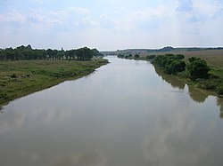
The Vaal River (/ˈvɑːl/Afrikaans pronunciation:[ˈfɑːl]; Khoemana: ǀHaiǃarib) is the largest tributary of the Orange River in South Africa. The river has its source near Breyten in Mpumalanga province, east of Johannesburg and about 30 kilometres (19 mi) north of Ermelo and only about 240 kilometres (150 mi) from the Indian Ocean.[1] It then flows westwards to its confluence with the Orange River southwest of Kimberley in the Northern Cape. It is 1,458 kilometres (906 mi) long, and forms the border between Mpumalanga, Gauteng and North West Province on its north bank, and the Free State on its south.
It is the third largest river in South Africa after the Orange River (2200 km long) and the Limpopo River (1750 km long) and was established as the main source of water for the great Witswatersrand area after the 19th century gold rush.[2] The Vaal Dam lies on the Vaal River in Deneysville just south of the border between Gauteng and the Free State. The Vaal River is the longest river wholly within the borders of South Africa.
Vaal is a Dutch name (later Afrikaans), translated by the Griquas or Boers[3] from an earlier Kora Khoekhoe or !Orakobab name, sometimes spelled as Tky-Gariep (in Khoekhoegowab orthography it is ǀHai!garib, drab river).[4]
Both Vaal and Tky (in modern orthography ǀHai) mean "drab" or "dull", which alludes to the colour of the waters, especially noticeable during flood season when the river is laden with silt. In the upper reaches the river was named iLigwa (Sindebele), Ikwa or Igwa (isiZulu), ilikwa (siSwati), lekwa (Sesotho), or cuoa by the Khoikhoi, all referring to the plain it traverses.[4]
^Times Comprehensive Atlas, 12th ed. Times Books, London, 2007
^9 longest rivers. SA9. Accessed 2 April 2018.
^Thompson, G. (1827). Travels and Adventures in Southern Africa I. Henry Colburn, London. p. 74.
^ ab
du Plessis, E.J. (1973). Suid-Afrikaanse berg- en riviername. Tafelberg-uitgewers, Cape Town. pp. 326, 221. ISBN 0-624-00273-X.
The VaalRiver (/ˈvɑːl/ Afrikaans pronunciation: [ˈfɑːl]; Khoemana: ǀHaiǃarib) is the largest tributary of the Orange River in South Africa. The river has...
opposed to the color of its tributary, the VaalRiver, which name is derived from the name ǀHaiǃarib "pale river" (vaal being Afrikaans for pale or grey). Since...
The Vaal Dam lies on the VaalRiver, which is one of South Africa's strongest-flowing rivers. Other rivers flowing into the dam are the Wilge River, Molspruit...
to live in the Vaal Triangle.[citation needed] The area straddles the VaalRiver and is a major industrial region, which is home to former Iron and Steel...
Mountains and then made an attempt to cross the VaalRiver. He was unsuccessful and drowned in the river along with a few others. After the death of his...
and Vaalrivers, while local European residents wanted the British to remain. This led to the British recognising the independence of the Orange River Sovereignty...
situated where the Klip River empties into the northern loop of the VaalRiver. It is also one of the constituent parts of the Vaal Triangle region and was...
State province, South Africa. It is situated on the southern bank of the VaalRiver. The name is the Afrikaans translation of Paris. The origin of the name...
Ireland formally recognised the independence of the Boers north of the VaalRiver. The convention was signed on 17 January 1852, by Commandant-General Andries...
industrial city with approximately 95,000 inhabitants, situated on the VaalRiver in the south of Gauteng province, South Africa. The city is named after...
Limpopo river. Potgieter declared the lands north and south of the Vaalriver as Boer lands.: 224 Boers started settling on both sides of the Vaalriver and...
The VaalRiver mine is a large mine located in the northern part of South Africa in Gauteng. VaalRiver represents one of the largest uranium reserves...
The Wilge River (Afrikaans: Wilgerivier, meaning "willow river") is a tributary of the VaalRiver in central South Africa. This river is important as...
Deneysville is a small town on the banks of the Vaal Dam in the Free State province of South Africa. Deneysville was established in 1936 and named after...
become an invasive species in rivers of the Eastern Cape, South Africa, such as the Mbhashe River. The Orange-VaalRiver system is one of the few in South...
impact, as telltale shatter cones were discovered in the bed of the nearby VaalRiver. This impact structure is one of the few multiple-ringed impact structures...
1852 Sand River Convention, in which the British government agreed to formally recognise independence of the Boers living north of the VaalRiver. Relations...
Northern Cape province of South Africa, situated on the north bank of the VaalRiver west of Kimberley. Barkly West was the site of the first major diamond...
The Riet River is a westward-flowing tributary of the VaalRiver in central South Africa. In precolonial times the Riet was known as the Gama-!ab (or...
the VaalRiver in the Lejweleputswa DM of the Free State province, South Africa. It is situated 60 km east of the Vaal, on the bank of its Vals River tributary...
is a large commercial and agricultural town lying on the banks of the VaalRiver in Mpumalanga, South Africa, which specialises in cattle, dairy, maize...
The Suikerbosrand River (Afrikaans: Suikerbosrandrivier) is a tributary of the VaalRiver that flows from Leandra in Mpumalanga, westwards through Gauteng...
the VaalRiver valley. Settlements of Bantu-speaking peoples, who were iron-using agriculturists and herdsmen, were present south of the Limpopo River (now...
to the VaalRiver, fixed his residence in the Magaliesberg, north of that river. He was chosen by the burghers living on both banks of the Vaal as their...
 Global Information