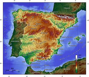
Relief map of peninsular Spain and the Balearic Islands.Map of Spain showing terrain altitude and topography.The Canary Islands, located in North Africa, are of volcanic origin.Hypsometric curve of peninsular Spain. In spite of being bathed by the Mediterranean Sea and the Atlantic Ocean, half of its surface is at 660 m or more above sea level.
The topographical relief of Spain is characterized by being quite high, with an average altitude of 660 meters above sea level, quite mountainous compared to other European countries and only surpassed by Switzerland, Austria, Albania, Montenegro, North Macedonia and the microstates of Andorra and Liechtenstein. In peninsular Spain, the terrain is articulated around a large Meseta Central (central plateau) that occupies most of the center of the Iberian Peninsula. Outside the plateau, there is the depression of the Guadalquivir river, located in the southwest of the peninsula, and the Ebro river depression, located in the northeast.
The mountain systems of Spain are very numerous and occupy almost half of the national territory. The Pyrenees (in the northeastern limit) and the Baetic System (in the southeast) are the highest mountain ranges, located outside the Meseta Central. Surrounding this is the Cantabrian Range in the north, the Iberian System in the east, and the Sierra Morena in the south. Within the Meseta Central is the Sistema Central and Montes de Toledo.
Two archipelagos of geographic interest belong to Spain: the Balearic Islands, located in the Mediterranean Sea, with a latitude similar to that of Castilla-La Mancha; and the Canary Islands, seven islands of volcanic origin located in the Atlantic Ocean, close to the coast of Western Sahara; and of less importance: the island of Alborán between Spain and Morocco and the Columbretes Islands in Castellón. Also from Spain are some small coastal enclaves in North Africa: the cities of Ceuta and Melilla, the Chafarinas Islands, the Peñon de Alhucemas and the Peñon de Velez de la Gomera.
The Spanish coast, bathed by the Atlantic Ocean and the Cantabrian and Mediterranean Seas, has a great diversity of beaches, cliffs and rias. The high (presence of cliffs and wave-cut platform) and articulated coast (presence of rias and capes) is the most predominant in the north and the Canary Islands, while the low coast (presence of beaches and coves) is typical of the south, the Mediterranean and the Balearic Islands.
and 25 Related for: Topography of Spain information
The topographical relief ofSpain is characterized by being quite high, with an average altitude of 660 meters above sea level, quite mountainous compared...
Topography is the study of the forms and features of land surfaces. The topographyof an area may refer to the land forms and features themselves, or...
Spain, or the Kingdom ofSpain, is a country located in Southwestern Europe, with parts of its territory in the Atlantic Ocean, the Mediterranean Sea and...
Both the perceived nationhood ofSpain, and the perceived distinctions between different parts of its territory derive from historical, geographical,...
(bathús) 'deep', and μέτρον (métron) 'measure') is the study of underwater depth of ocean floors (seabed topography), lake floors, or river floors. In other words,...
mid-1500s. New Spain developed strong regional divisions based on local climate, topography, distance from the capital and the Gulf Coast port of Veracruz,...
; Spanish: Cataluña [kataˈluɲa] ; Occitan: Catalonha [kataˈluɲa]) is an autonomous community ofSpain, designated as a nationality by its Statute of Autonomy...
distance or local topography. Regional Spanish channels (like TV Galicia or Extremadura TV) usually acknowledge this and cover local events of the border communities...
characterized by a distinctive badlands topography. This is terrain in which water erosion has cut a very large number of deep drainage channels, separated...
The Spanish Virgin Islands (Spanish: Islas Vírgenes Españolas), formerly called the Passage Islands (Spanish: Islas del Pasaje) and also known as the Puerto...
The Shuttle Radar Topography Mission (SRTM) is an international research effort that obtained digital elevation models on a near-global scale from 56°S...
elevation profile by means of numerical differentiation. Fall line (topography) "ESTUDIO DEL MAPA TOPOGRÁFICO" (in Spanish). Madrid: Instituto de Enseñanza...
largest island of the Balearic Islands, which are part ofSpain, and the seventh largest island in the Mediterranean Sea. The capital of the island, Palma...
The history of education in Spain is marked by political struggles and the progress of modern societies. It began in the late Middle Ages, very close to...
populous city in Canada and the capital city of the Canadian province of Ontario. With a population of 2,794,356 in 2021, it is the fourth-most populous...
TEN-ə-REEF; Spanish: [teneˈɾife]; formerly spelled Teneriffe) is the largest and most populous island of the Canary Islands. It is home to 42.9% of the total...
of the autonomous community of Galicia, in northwestern Spain. The city has its origin in the shrine of Saint James the Great, now the Cathedral of Santiago...
Spanish, Polish, Bengali and Portuguese. According to the 2021 Census, the largest religious groupings were Christians (40.66%), followed by those of...
defining the westernmost edge of Eurasia. It is divided between Continental Portugal and Peninsular Spain, comprising most of the region, as well as Andorra...
miles) west of Morocco and the Western Sahara. They are the southernmost of the autonomous communities ofSpain. The islands have a population of 2.2 million...
Maya, before the Spanish colonization in the sixteenth century. The Spanish introduced Catholicism and the now predominant Spanish language, along with...
Karst (/kɑːrst/) is a topography formed from the dissolution of soluble carbonate rocks such as limestone, dolomite, and gypsum. It is characterized by...
valleys, steep cliffs, and rocky outcrops. The park’s topography is the result of millions of years of erosion by the Douro River, creating a stunning and...
poetry, Spanish Classics, Spanish Composition, Topography, and Trigonometry. Among the subjects being taught to girls, as reflected in the curriculum of the...
politics and the topographyof the city of Rome itself. [...] The Revolt's failure had, to begin with, a demographic impact on the Jews of Palestine; many...
 Global Information