 Global Information
Shuttle Radar Topography Mission information
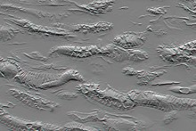

The Shuttle Radar Topography Mission (SRTM) is an international research effort that obtained digital elevation models on a near-global scale from 56°S to 60°N,[2]: 4820 to generate the most complete high-resolution digital topographic database of Earth prior to the release of the ASTER GDEM in 2009. SRTM consisted of a specially modified radar system that flew on board the Space Shuttle Endeavour during the 11-day STS-99 mission in February 2000. The radar system was based on the older Spaceborne Imaging Radar-C/X-band Synthetic Aperture Radar (SIR-C/X-SAR), previously used on the Shuttle in 1994. To acquire topographic data, the SRTM payload was outfitted with two radar antennas.[2] One antenna was located in the Shuttle's payload bay, the other – a critical change from the SIR-C/X-SAR, allowing single-pass interferometry – on the end of a 60-meter (200-foot) mast that extended from the payload bay once the Shuttle was in space.[2] The technique employed is known as interferometric synthetic aperture radar. Intermap Technologies was the prime contractor for processing the interferometric synthetic aperture radar data.
The elevation models are arranged into tiles, each covering one degree of latitude and one degree of longitude, named according to their south western corners. For example, "n45e006" stretches from 45°N 6°E to 46°N 7°E and "s45w006" from 45°S 6°W to 44°S 5°W. The resolution of the raw data is one arcsecond (30 m along the equator) and coverage includes Africa, Europe, North America, South America, Asia, and Australia.[3] A derived one arcsecond dataset with trees and other non-terrain features removed covering Australia was made available in November 2011; the raw data are restricted for government use.[4] For the rest of the world, only three arcsecond (90 m along the equator) data are available.[2]: 4821 Each one arcsecond tile has 3,601 rows, each consisting of 3,601 16 bit bigendian cells. The dimensions of the three arcsecond tiles are 1201 x 1201. The original SRTM elevations were calculated relative to the WGS84 ellipsoid and then the EGM96 geoid separation values were added to convert to heights relative to the geoid for all the released products.[5]
The elevation models derived from the SRTM data are used in geographic information systems. They can be downloaded freely over the Internet, and their file format (.hgt) is widely supported.
The Shuttle Radar Topography Mission is an international project spearheaded by the U.S. National Geospatial-Intelligence Agency (NGA), an agency of the U.S. Department of Defense, and the U.S. National Aeronautics and Space Administration (NASA). NASA transferred the SRTM payload to the Smithsonian National Air and Space Museum in 2003; the canister, mast, and antenna are now on display at the Steven F. Udvar-Hazy Center in Chantilly, Virginia.[6]
- ^ "Shuttle Radar Topography Mission: Mission to Map the World". Archived from the original on 2008-08-23. Retrieved 2009-04-26.
- ^ a b c d Nikolakopoulos, K. G.; Kamaratakis, E. K; Chrysoulakis, N. (10 November 2006). "SRTM vs ASTER elevation products. Comparison for two regions in Crete, Greece" (PDF). International Journal of Remote Sensing. 27 (21): 4819–4838. Bibcode:2006IJRS...27.4819N. doi:10.1080/01431160600835853. ISSN 0143-1161. S2CID 1939968. Archived from the original (PDF) on 21 July 2011. Retrieved 1 July 2009.
- ^ "NASA Shuttle Radar Topography Mission (SRTM) Version 3.0 Global 1 arc second Data Released over Asia and Australia Version 1.0". Archived from the original on 2017-05-13.
- ^ "SRTM-derived 1 Second Digital Elevation Models Version 1.0". Archived from the original on 2012-02-28.
- ^ Hirt, C.; Filmer, M.S.; Featherstone, W.E. (2010). "Comparison and validation of recent freely-available ASTER-GDEM ver1, SRTM ver4.1 and GEODATA DEM-9S ver3 digital elevation models over Australia". Australian Journal of Earth Sciences. 57 (3): 337–347. Bibcode:2010AuJES..57..337H. doi:10.1080/08120091003677553. hdl:20.500.11937/43846. S2CID 140651372. Archived from the original on May 3, 2013. Retrieved May 5, 2012.
- ^ "Cannister/Mast, Shuttle Radar Topography Mission Payload". Smithsonian National Air and Space Museum. Archived from the original on 9 August 2014. Retrieved 24 July 2014.