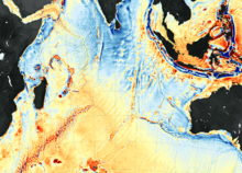
Bathymetry of the ocean floor showing the continental shelves and oceanic plateaus (red), the mid-ocean ridges (yellow-green) and the abyssal plains (blue to purple)
Methane venting offshore VirginiaA seafloor map captured by NASA
Bathymetry (/bəˈθɪmətri/; from Ancient Greek βαθύς (bathús) 'deep', and μέτρον (métron) 'measure')[1][2] is the study of underwater depth of ocean floors (seabed topography), lake floors, or river floors. In other words, bathymetry is the underwater equivalent to hypsometry or topography. The first recorded evidence of water depth measurements are from Ancient Egypt over 3000 years ago.[3]Bathymetric charts (not to be confused with hydrographic charts), are typically produced to support safety of surface or sub-surface navigation, and usually show seafloor relief or terrain as contour lines (called depth contours or isobaths) and selected depths (soundings), and typically also provide surface navigational information. Bathymetric maps (a more general term where navigational safety is not a concern) may also use a Digital Terrain Model and artificial illumination techniques to illustrate the depths being portrayed. The global bathymetry is sometimes combined with topography data to yield a global relief model. Paleobathymetry is the study of past underwater depths.
Synonyms include seafloor mapping, seabed mapping, seafloor imaging and seabed imaging. Bathymetric measurements are conducted with various methods, from depth sounding, sonar and Lidar techniques, to buoys and satellite altimetry. Various methods have advantages and disadvantages and the specific method used depends upon the scale of the area under study, financial means, desired measurement accuracy, and additional variables. Despite modern computer-based research, the ocean seabed in many locations is less measured than the topography of Mars.[4]
^βαθύς, Henry George Liddell, Robert Scott, A Greek-English Lexicon, on Perseus
^μέτρον, Henry George Liddell, Robert Scott, A Greek-English Lexicon, on Perseus
^Wölfl, A.C.; Snaith, H.; Amirebrahimi, S.; et al. (2019). "Seafloor Mapping – The Challenge of a Truly Global Ocean Bathymetry". Frontiers in Marine Science. 6: 283. doi:10.3389/fmars.2019.00283.
^Jones, E.J.W. (1999). Marine geophhysics. New York: Wiley.
Bathymetry (/bəˈθɪmətri/; from Ancient Greek βαθύς (bathús) 'deep', and μέτρον (métron) 'measure') is the study of underwater depth of ocean floors (seabed...
frequency doubled solid-state IR laser output is the standard for airborne bathymetry. This light can penetrate water but pulse strength attenuates exponentially...
bathymetric profiles which are vertical sections through a feature. The use of bathymetry and the development of bathymetric charts dates back around the 19th century...
submersibles, remotely operated underwater vehicles, benthic landers, and sonar bathymetry. The differences in depth estimates and their geodetic positions are scientifically...
measurement of altitude is called altimetry, which is related to the term bathymetry, the measurement of depth under water. Altitude can be determined based...
which are believed to be new species. The first high-resolution multibeam bathymetry of the central DFZ was collected between June 2014 and June 2016, for...
Huron Michigan lighthouses National Geophysical Data Center (1999). "Bathymetry of Lake Erie and Lake Saint Clair". National Oceanographic and Atmospheric...
Bathymetry of the ocean floor showing the continental shelves and oceanic plateaus (red), the mid-ocean ridges (yellow-green) and the abyssal plains (blue...
Sherman; MacLeod, Christopher; Taylor, Brian; Goodliffe, Andrew (2000). "Bathymetry of the Tonga Trench and Forearc: A Map Series". Marine Geophysical Researches...
the mantle. Where not covered by sediments, the seafloor is deeper and bathymetry more rugged than normal. The most recent, "zero-age" seafloor of the Philippine...
and the global oceanic circulation, as well as the global climate. The bathymetry of the Drake Passage plays an important role in the global mixing of oceanic...
MR1 mapping system. This mapping system has the ability to record both bathymetry and sidescan data at the same time. The two vessels that this system was...
Bénard et al. 2010, Introduction, pp. 1–2 NOAA Bathymetry Viewer https://maps.ngdc.noaa.gov/viewers/bathymetry/ Bénard et al. 2010, Geological and plate boundary...
systems of the oceans, and the shape of the coastline and near-shore bathymetry (see Timing). They are however only predictions, the actual time and height...
Pfirman, Stephanie; Schenke, Hans Werner; Reil, Wolfgang (1990-08-01). "Bathymetry of Molloy Deep: Fram Strait between Svalbard and Greenland". Mar. Geophys...
Bransfield Basin Bathymetry map of the Bransfield Basin created using Geomap App software with a bathymetry map overlay with a distance and elevation scale...
The Bering Strait (Russian: Берингов пролив, romanized: Beringov proliv) is a strait between the Pacific and Arctic oceans, separating the Chukchi Peninsula...
thick craton with no active volcanism after the Proterozoic, and regional bathymetry explains the "runway" formation under the anomaly as part of a larger...
2010. From left to right: Lake Superior, Michigan, Huron, Erie, Ontario Bathymetry map of the Great Lakes Location Eastern North America Coordinates 45°N...
bathymetry over time. Bathymetry of tidal channels is determined using multi-beam sonar or LiDAR. By comparing cross-sections of channel bathymetry over...
Traverse Bay Port of Milwaukee National Geophysical Data Center, 1996. Bathymetry of Lake Michigan. National Geophysical Data Center, NOAA. doi:10.7289/V5B85627...
Nepheloid layers can impact the accuracy of instruments when measuring bathymetry as well as affect the types of marine life in an area. There are several...
The Pacific Ocean is the largest and deepest of the Earth's five oceanic divisions. It extends from the Arctic Ocean in the north to the Southern Ocean...
Marmara – 11,350 km2 Wadden Sea – 10,000 km2 Archipelago Sea – 8,300 km2 The bathymetry of the Atlantic is dominated by a submarine mountain range called the...
море (Ukrainian) The location of the Black Sea Map of the Black Sea with bathymetry and surrounding relief Location Eastern Europe and West Asia Coordinates...
Map all coordinates in "Geography of the North Sea" using OpenStreetMap Download coordinates as: KML GPX (all coordinates) GPX (primary coordinates) GPX...
 Global Information