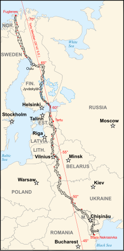
Meridian arc from Hammerfest in Norway to the Black Sea
This article needs additional citations for verification. Please help improve this article by adding citations to reliable sources. Unsourced material may be challenged and removed. Find sources: "Struve Geodetic Arc" – news · newspapers · books · scholar · JSTOR(November 2012) (Learn how and when to remove this template message)
Struve Geodetic Arc
The northernmost station of the Struve Geodetic Arc is located in Fuglenes, Norway.
Map of the Struve Geodetic Arc where red points identify the World Heritage Sites.
General information
Type
Ensemble of memorable sites
Location
Estonia, Belarus, Finland, Latvia, Lithuania, Norway, Moldova, Russia, Sweden, and Ukraine
Tartu Old Observatory, the first point of the arc.Point Z, situated on Hogland, Russia.The commemorative plaque of the arc in Felshtyn, UkraineThe Geodetic Point in Rudi, Moldova
The Struve Geodetic Arc is a chain of survey triangulations stretching from Hammerfest in Norway to the Black Sea, through ten countries and over 2,820 kilometres (1,750 mi), which yielded the first accurate measurement of a meridian arc.[1]
The chain was established and used by the German-born Russian scientist Friedrich Georg Wilhelm von Struve in the years 1816 to 1855 to establish the exact size and shape of the earth. At that time, the chain passed merely through three countries: Norway, Sweden and the Russian Empire. The Arc's first point is located in Tartu Observatory in Estonia, where Struve conducted much of his research.[1] Measurement of the triangulation chain comprises 258 main triangles and 265 geodetic vertices.[2] The northernmost point is located near Hammerfest in Norway and the southernmost point near the Black Sea in Ukraine.
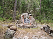
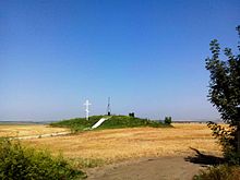
In 2005, the chain was inscribed on the World Heritage List, because of its importance in geodesy and its testimony to international scientific cooperation.[2] The World Heritage site includes 34 commemorative plaques or built obelisks out of the original 265 main station points which are marked by drilled holes in rock, iron crosses, cairns, others.[1] This inscription is located in ten countries, the second most of any UNESCO World Heritage after the Ancient and Primeval Beech Forests of the Carpathians and Other Regions of Europe.[1][3]
The measurements of the 30° Meridian Arc in 1816–1852 as well the description of the geodesic, topographical, and map making works in the Balkans from the nineteenth century until the beginning of the twentieth century by Russian Czarist Army was described in Astronomy, geodesy and map- drawing in Moldova since the middle ages till the World War I.[4]
^ abcdCite error: The named reference nor was invoked but never defined (see the help page).
^ ab"Struve Geodetic Arc". UNESCO World Heritage Centre. United Nations Educational, Scientific, and Cultural Organization. Retrieved 11 September 2021.
^"Ancient and Primeval Beech Forests of the Carpathians and Other Regions of Europe". UNESCO World Heritage Centre. Retrieved 13 March 2021.
^A. Găină, Astronomy, geodesy and map-drawing in Moldova since the middle ages till the World WarI, Serbian Astron. J., N.162 (2000), pp. 121–125
and 30 Related for: Struve Geodetic Arc information
The StruveGeodeticArc is a chain of survey triangulations stretching from Hammerfest in Norway to the Black Sea, through ten countries and over 2,820...
initiating a triangulation survey later named StruveGeodeticArc in his honor. He was born to the aristocratic Struve family at Altona, Duchy of Holstein (then...
Tallinn StruveGeodeticArc The United Nations Educational, Scientific and Cultural Organization (UNESCO) World Heritage Sites are places of importance...
Viik, T (2006). "F. W. Bessel and geodesy". StruveGeodeticArc, 2006 International Conference, The StruveArc and Extensions in Space and Time, Haparanda...
Riga Kuldīga StruveGeodeticArc The United Nations Educational, Scientific and Cultural Organization (UNESCO) World Heritage Sites are places of importance...
Vilnius Curonian Spit Kernavė Kaunas StruveGeodeticArc The United Nations Educational, Scientific and Cultural Organization (UNESCO) designates World...
Sammallahdenmäki Suomenlinna Kvarken Old Rauma Petäjävesi Old Church Verla StruveGeodeticArc The United Nations Educational, Scientific and Cultural Organization...
and the United Kingdom. More ambitious undertakings such as the StruveGeodeticArc across Eastern Europe (1816-1855) and the Great Trigonometrical Survey...
internationally for its connection to Friedrich Georg Wilhelm von Struve and the StruveGeodeticArc, of which it is the first reference point. The Tartu Observatory...
StruveGeodeticArc The United Nations Educational, Scientific and Cultural Organization (UNESCO) World Heritage Sites are places of importance to cultural...
Rjukan–Notodden Alta Røros Urnes Vegaøyan Geirangerfjord Nærøyfjord StruveGeodeticArc The United Nations Educational, Scientific and Cultural Organization...
Rudi Geodetic Point (Romanian: Punctul Geodezic Rudi) is a point of the StruveGeodeticArc in Rudi, Moldova. There is also an obelisk. Rudi Geodetic Point...
the famous survey triangulation measurements of the angular arc (named StruveGeodeticArc). The measurements extended through over 2,820 km, from Hammerfest...
Southern Öland High Coast Great Copper Mountain Varberg Radio Station StruveGeodeticArc The United Nations Educational, Scientific and Cultural Organization...
Viik, T (2006). "F. W. Bessel and geodesy". StruveGeodeticArc, 2006 International Conference, The StruveArc and Extensions in Space and Time, Haparanda...
Since 1826, the hill Mäkiinpäällys has two of the points in the StruveGeodeticArc. Gogland has a humid continental climate (Dfb) with oceanic influences...
Landscapes of Dauria and Uvs Nuur Basin are shared with Mongolia, and the StruveGeodeticArc is shared with nine European countries. UNESCO lists sites under...
Bouguer et al.). Struve measured a geodetic control network via triangulation between the Arctic Sea and the Black Sea, the StruveGeodeticArc. Bessel compiled...
other three are cultural. In addition to Białowieża Forest, the StruveGeodeticArc is also a transnational site, and is shared with nine other countries...
Kyiv Residence of Metropolitans Lviv Odesa Chersonesus StruveGeodeticArc The United Nations Educational, Scientific and Cultural Organization (UNESCO)...
shared between Austria, Germany and Slovakia. The cultural site StruveGeodeticArc is shared among Belarus, Estonia, Finland, Latvia, Lithuania, Norway...
Norway. It is the location of the northernmost point of the StruveGeodeticArc. It is a geodetic point, one of the 34 points selected for the World Heritage...
Triangulation of Great Britain Meridian arc History of geodesy History of the metre Seconds pendulum StruveGeodeticArc 48°50′11″N 2°20′14.025″E / 48.83639°N...
meridian (West Europe-Africa Meridian-arc) French Geodesic Mission to Lapland French Geodesic Mission StruveGeodeticArc Rectifying latitude Geodesics on...
Hungary), Muskauer Park / Park Mużakowski (Germany and Poland), the StruveGeodeticArc (ten countries in Northern and Eastern Europe), and Erzgebirge/Krušnohoří...
 Global Information