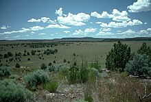
Oregon High Desert near Frenchglen, about four miles north of the trailOregon Badlands near the west end of the trail with a mixture of sage, pine, tumulus, and ash-like soil
The Oregon Desert Trail is a network[1] of trails, cross country travel and two-track dirt roads across the Oregon High Desert. The trail is approximately 750 miles long,[2] with termini located near Bend, Oregon, and near the Idaho border at Lake Owyhee State Park.[3][4]
The route is on existing trails and across tracts of public land—mostly Bureau of Land Management, much of it wilderness study area. The west end of the trail is on the northern border of Oregon Badlands Wilderness and heads south. It meanders widely to take in public land throughout southeastern Oregon: Diablo Peak, Fremont National Forest, Hart Mountain National Antelope Refuge, Steens Mountain, the Pueblo Mountains, the Trout Creek Mountains, and the Owyhee River Wilderness. It passes through the tiny cities of Christmas Valley, Paisley, Plush, Frenchglen, Fields, McDermitt, Rome, and Adrian.[5] The trail runs South East from Central Oregon, towards Lakeview.[6] It touches on the Oregon-Nevada border at of Denio, Nevada and again at McDermitt, Nevada. The route zigzags eastward to within 15 miles (24 km) of the southeastern state corner while following the West Little Owyhee River downstream and then turns northward as it merges to form the Owyhee River. The trail's ends are west-northwest to east-southeast (96° true) of each other by 195 miles (314 km). The route was developed by the Oregon Natural Desert Association (ONDA).[2]
The Oregon Desert Trail is set apart from other similar trails, such as the Pacific Crest Trail, in that it: offers more solitude - there is little to no traffic on the route,[7] one must rely on their own navigational skills - there is no dedicated signage, and it is a very dry trail with extended water carries and water caches necessary. This trail is not recommended for beginners, as it is difficult and requires extensive planning, has limited access to water, limited resupply locations, and requires hikers to rely on their navigational skills.[8]
Bikes are allowed on parts of the trail,[9] but are not practical in some areas[9] and are not allowed in wilderness areas.[10] Sections can be paddled, explored on skis, horseback, or biked.
^"Archived copy". www.mensjournal.com. Archived from the original on 2015-04-07.{{cite web}}: CS1 maint: archived copy as title (link)
^ abBurns, Joe (8 June 2013). "Bend woman blazing trail to preserve high desert". KTZV. Retrieved 7 June 2013.
^Morical, Mark (5 June 2013). "Bend hiker hopes to hike trail first". The Bulletin. Retrieved 6 June 2013.
^"Across the Oregon Desert Trail". Oregon Natural Desert Association. Retrieved 6 June 2013.
^Richard, Terry (6 October 2012). "Oregon Desert Trail envisioned as 750-mile Bend-to-Idaho crossing". The Oregonian. Retrieved 6 June 2013.
^See detailed map
^Neville, Tim (19 August 2011). "Bivouacking in Oregon's Back of Beyond". The New York Times.
^"Oregon Natural Desert Association - Explore the High Desert".
^ abRichard, Terry (6 June 2013). "Sage Clegg, first through hiker on the Oregon Desert Trail, begins 800-mile trek". The Oregonian. Retrieved 7 June 2013.
^Bradley, John (16 February 2010). "Spurning Rubber". Outside.
and 22 Related for: Oregon Desert Trail information
The OregonDesertTrail is a network of trails, cross country travel and two-track dirt roads across the Oregon High Desert. The trail is approximately...
The OregonTrail was a 2,170-mile (3,490 km) east–west, large-wheeled wagon route and emigrant trail in the United States that connected the Missouri River...
The Applegate Trail was an emigrant trail through the present-day U.S. states of Idaho, Nevada, California, and Oregon used in the mid-19th century by...
The historic 2,170-mile (3,490 km) OregonTrail connected various towns along the Missouri River to Oregon's Willamette Valley. It was used during the...
of the Missouri-based routes—the Oregon, California, and Mormon Trails—were collectively known as the Emigrant Trails. Historians have estimated at least...
half of the California Trail followed the same corridor of networked river valley trails as the OregonTrail and the Mormon Trail, namely the valleys of...
instead head west across the Oregon High Desert, straight to the Willamette Valley. They left the main trail at Vale, Oregon and followed the Malheur River...
Windy Joe Trail within Manning Park in British Columbia; it passes through the states of California, Oregon, and Washington. The Pacific Crest Trail is 2,653 mi...
marking of a wilderness hiking trail from Bend, Oregon to the Idaho border. This trail, now known as the OregonDesertTrail, has won accolades from outdoor...
wilderness is home to the western terminus of the OregonDesertTrail. The wilderness is situated on high desert terrain and is associated with a volcanic rootless...
The cutoff left the OregonTrail at Fort Bridger in Wyoming, passed through the Wasatch Range, across the Great Salt Lake Desert, an 80-mile nearly water-less...
The High Desert Museum is located near Bend, Oregon, United States. Opened in 1982, it brings regional wildlife, culture, art and natural resources together...
The Emigrant Trail in Wyoming, which is the path followed by Western pioneers using the Oregon, California, and Mormon Trails (collectively referred to...
passes. The desert of Utah follows, then Sawtooth National Forest of Idaho and the Deschutes National Forest of Oregon, to name a few. The trail is traveled...
Oregon (/ˈɒrɪɡən, -ɡɒn/ ORR-ih-ghən, -gon) is a state in the Pacific Northwest region of the United States. Oregon is a part of the Western United States...
covered large sections of Eastern Oregon 6 to 17 million years ago. Other landforms include the Alvord Desert, Owyhee Desert, Warner Valley, Deschutes River...
Road in 1845 as they crossed the juniper desert on their way to the Willamette Valley. Oregon Historic Trails Advisory Council http://blog.oregonlive...
the OregonTrail. According to Erb, Brown and Hughes, "From the Green River this trail went eastward along Bitter Creek, skirting the Red Desert to Muddy...
crossing the desert headed for California and Oregon. In 1843, John Fremont and his party were the first white men to cross the desert, and his trail was used...
(2000). Order of Battle: Allied Ground Forces of Operation Desert Storm. Central Point, Oregon: Hellgate Press. ISBN 978-1-55571-493-2. Burton, James G...
the gently-rolling, water-scarce Red Desert. South Pass. The OregonTrail, the California Trail and the Mormon Trail traversed this area in the 19th century...
 Global Information