 Global Information
Pacific Crest Trail information
| Pacific Crest Trail | |
|---|---|
| Length | 2,653 mi (4,270 km)[1] |
| Location | California / Oregon / Washington, USA / British Columbia, Canada |
| Designation | National Scenic Trail |
| Trailheads | Campo, California Manning Park, British Columbia |
| Use | Hiking Horseback riding |
| Elevation change | 489,000 ft (149,000 m)[2] |
| Highest point | Forester Pass, 13,153 ft (4,009 m)[3] |
| Lowest point | Cascade Locks, 140 ft (43 m)[4] |
| Months | Late April to Late September |
| Sights | Sierra Nevada (U.S.) Cascade Range |
| Hazards | Severe weather Dehydration Avalanches Falling Forest fires Landslides Volcanic ash (rare) Black bears Venomous snakes Hypothermia Mountain lions Diarrhea from water |
| Trail map | |
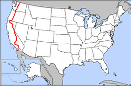 | |
The Pacific Crest Trail (PCT), officially designated as the Pacific Crest National Scenic Trail, is a long-distance hiking and equestrian trail closely aligned with the highest portion of the Cascade and Sierra Nevada mountain ranges, which lie 100 to 150 miles (160 to 240 km) east of the U.S. Pacific coast. The trail's southern terminus is next to the Mexico–United States border, just south of Campo, California, and its northern terminus is on the Canada–US border, upon which it continues unofficially to the Windy Joe Trail within Manning Park in British Columbia; it passes through the states of California, Oregon, and Washington.
The Pacific Crest Trail is 2,653 mi (4,270 km) long[1] and ranges in elevation from roughly 110 feet (34 m)[7] above sea level near the Bridge of the Gods on the Oregon–Washington border to 13,153 feet (4,009 m)[3] at Forester Pass in the Sierra Nevada. The route passes through 25 national forests and 7 national parks.[10] Its midpoint is near Chester, California (near Mt. Lassen), where the Sierra and Cascade mountain ranges meet.[11] The overall elevation gain for the Pacific Crest Trail is approximately 489,000 ft (149,000 m).[2]
It was designated a National Scenic Trail in 1968, although it was not officially completed until 1993.[12] The PCT was conceived by Clinton Churchill Clarke in 1932.[13] It received official status under the National Trails System Act of 1968.
The Pacific Crest Trail, the Appalachian Trail, and the Continental Divide Trail form what is known as the Triple Crown of Hiking in the United States.[14] The Pacific Crest Trail is also part of the 6,875-mile Great Western Loop.
- ^ a b Halfmile's Pacific Crest Trail Notes - Ashland, OR to Manning Park, BC (PDF), archived from the original (PDF) on March 9, 2016, retrieved March 5, 2016
- ^ a b "Crater Lake: Reflections Visitor Guide" (PDF). National Park Service. 2022. p. 4. Retrieved February 26, 2024.
- ^ a b Sources disagree on Forester Pass's elevation. The Forest Service claims 13,180 feet (4,017 m)[8] while the USGS says 13,153 feet (4,009 m),[9] but topographic maps showing 36°41′39″N 118°22′19″W / 36.6941°N 118.3720°W indicate a little less than 13,123 feet (4,000 m).
- ^ "Pacific Crest National Scenic Trail". USFS. Archived from the original on January 16, 2010.
- ^ "PCT data".
- ^ "USGS 1 Meter 10 x58y506 WA_FEMAHQ_2018_D18 - ScienceBase-Catalog".
- ^ The bridge deck itself lies at ~180 feet above sea level, with the water below at ~77 feet. North of the bridge, the trail declines slightly in elevation to about 108 ft near Wauna Lake Road, about a mile past the bridge. The Eagle Creek Trail, a popular alternate route on the Oregon side, reaches a lower elevation of 80 feet (24 m). This is according to PCT's official trail data[5] used on a 1m DEM from USGS/FEMA[6]
- ^ "Pacific Crest Trail – Central California Online Map and Guide". USFS. April 26, 2005. Archived from the original on May 25, 2006. Retrieved September 23, 2006.
- ^ "Forester Pass". Geographic Names Information System. United States Geological Survey, United States Department of the Interior.
- ^ "Pacific Crest National Scenic Trail." Parks Directory of the United States. 2004 ed.
- ^ Backpacker Magazine. "Pacific Crest Trail: CA Section 31". Trimble Outdoors. Archived from the original on April 2, 2015. Retrieved March 29, 2015.
- ^ Cite error: The named reference
pcthistwas invoked but never defined (see the help page). - ^ Gally, Sid. "The Pacific Crest Trail had its roots in Pasadena". Pasadena Star News. Archived from the original on January 14, 2015.
- ^ Berger, Karen (2001). Hiking the Triple Crown: How to Hike America's Longest Trails : Appalachian Trail, Pacific Crest Trail, Continental Divide Trail. Seattle: Mountaineers Press. ISBN 978-0-89886-760-2.