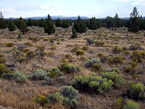
Oregon Badlands with sagebrush in bloom, Juniper trees, and proximity to Oregon Cascades
Location
Deschutes / Crook counties, Oregon, United States
Nearest city
Bend, Oregon
Coordinates
44°00′N121°02′W / 44°N 121.04°W / 44; -121.04
Area
29,301 acres (11,858 ha)
Established
United States Bureau of Land Management
The Oregon Badlands Wilderness is a 29,301-acre (11,858 ha) wilderness area located east of Bend in Deschutes and Crook counties in the U.S. state of Oregon. The wilderness is managed by the Bureau of Land Management as part of the National Landscape Conservation System and was created by the Omnibus Public Land Management Act of 2009, which was signed into law by President Barack Obama on 30 March 2009.[1]
The area is known for igneous castle-like rock formations, harsh terrain, ancient Juniper trees, sagebrush, and extensive arid land. Desert wildflowers, dry river canyons, and Native American pictographs can be found.[2]
The blind iditarod racer Rachel Scdoris trained in the area,[3] and the wilderness is home to the western terminus of the Oregon Desert Trail.[4][5]
^"Obama signs public lands reform bill". CNN. 30 March 2009. Archived from the original on 31 March 2009. Retrieved 30 March 2009.
^"Wyden announces wilderness legislation for Badlands in Deschutes County". Press Release of Senator Wyden. U.S. Senate newsroom. 27 May 2008. Retrieved 10 July 2008.
^Morical, Mark (5 June 2013). "Bend hiker hopes to hike trail first". The Bulletin. Bend, Oregon. Retrieved 6 June 2013.
^"Across the Oregon Desert Trail". Oregon Natural Desert Association. Retrieved 6 June 2013.
and 22 Related for: Oregon Badlands Wilderness information
The OregonBadlandsWilderness is a 29,301-acre (11,858 ha) wilderness area located east of Bend in Deschutes and Crook counties in the U.S. state of Oregon...
Management, much of it wilderness study area. The west end of the trail is on the northern border of OregonBadlandsWilderness and heads south. It meanders...
Central Oregon's geographical features range from high desert and volcanic rock formations resulting from lava beds. The OregonBadlandsWilderness is in...
of controlled burns by local officials are more frequent. The OregonBadlandsWilderness preserves the indigenous character, flora, and fauna of the desert...
The National Wilderness Preservation System includes 806 wilderness areas protecting 111,889,002 acres (174,826.566 sq mi; 452,798.73 km2) of federal land...
County, Oregon, United States. It is located south of Highway 20, west of the Millican community, and south of the OregonBadlandsWilderness. The Horse...
Central Oregon's geographical features range from high desert and volcanic rock formations resulting from lava beds. The OregonBadlandsWilderness is in...
Theodore Roosevelt National Park is an American national park of the badlands in western North Dakota comprising three geographically separated areas....
The Three Sisters Wilderness is a wilderness area in the Cascade Range, within the Willamette and Deschutes National Forests in Oregon, United States. It...
Eagle Cap Wilderness is a wilderness area located in the Wallowa Mountains of northeastern Oregon (United States), within the Wallowa–Whitman National...
Lower White River Wilderness. 31,000 acres (125 km2) in the OregonBadlands. (see OregonBadlandsWilderness and Spring Basin Wilderness) 23,000 acres (93 km2)...
Moraine-Dammed Lake, Three Fingered Jack Volcano, Mount Jefferson Wilderness, Oregon". Archived from the original on 2 June 2018. Retrieved 16 August 2020...
Lava Butte is a cinder cone in central Oregon, United States, just west of U.S. Route 97 between the towns of Bend, and Sunriver in Deschutes County. It...
Wildlife Refuges comprising the Oregon Coast National Wildlife Refuge Complex. The Oregon Islands provides wilderness protection to 1,853 small islands...
large Quaternary basalt fields in the eastern part of the U.S. state of Oregon. The field is thought to be approximately 3200 years old, based on findings...
Powell Butte is an extinct cinder cone butte in Portland, Oregon, United States. It is part of the Boring Lava Field, which includes more than 80 small...
publication by geologist Edwin T. Hodge. It was proposed to exist in central Oregon at the present day location of the Three Sisters region. It was estimated...
volcanic field located south east of Newberry Caldera in the U.S. state of Oregon. The volcanic field covers about 30 square kilometers and post-dates Mount...
Battle Ax is a shield volcano in the West Cascade Range of Oregon. The shield is mostly made of andesite. The summit, which can be reached via the Battle...
properly a single mountain, the largest of Oregon's fault-block mountains. The Steens Mountain Wilderness encompasses 170,166 acres (68,864 ha) of Steens...
The Opal Creek Wilderness is a wilderness area located in the Willamette National Forest in the U.S. state of Oregon, on the border of the Mount Hood...
him in another project called Badlands House Band. This band is part of a larger project in Sioux Falls SD called Badlands Pawn. and the brain child of...
 Global Information