Long-distance scenic trail in the western United States
Continental Divide Trail
Length
3,028 mi (4,873 km)
Location
United States
Designation
National Scenic Trail in 1978
Trailheads
Northern: Waterton Lakes National Park, Alberta, Glacier National Park, Montana at the U.S.–Canada border Southern: Crazy Cook Monument, Big Hatchet Mountains, New Mexico at the U.S.–Mexico border
Use
Hiking some Horseback riding some Mountain biking
Highest point
Grays Peak, Colorado, 14,278 ft (4,352 m)
Lowest point
Lordsburg, New Mexico and Waterton Lakes, Alberta, 4,200 ft (1,300 m)
Months
April to October
Sights
Continental Divide
Hazards
Avalanches Black bears Dehydration Falling Grizzly bears Hypothermia Landslides Lightning Mountain lions Severe weather Snow
Website
http://www.continentaldividetrail.org/
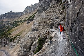
The Highline Trail (Glacier National Park) is part of the CDT.
The Continental Divide National Scenic Trail (in short Continental Divide Trail, CDT) is a United States National Scenic Trail with a length measured by the Continental Divide Trail Coalition of 3,028 miles (4,873 km) between the U.S. border with Chihuahua, Mexico and the border with Alberta, Canada.[1] Frequent route changes and a large number of alternate routes result in an actual hiking distance of 2,700 miles (4,300 km) to 3,150 miles (5,070 km).[2] The CDT follows the Continental Divide of the Americas along the Rocky Mountains and traverses five U.S. states — Montana, Idaho, Wyoming, Colorado, and New Mexico. In Montana near the Canadian border the trail crosses Triple Divide Pass (near Triple Divide Peak, from which waters may flow to either the Arctic Ocean (via Hudson Bay), Atlantic Ocean or Pacific Ocean).
In 2021, the CDT was about 70 percent complete, with a combination of dedicated trails and dirt and paved roads. Hikers can continue north into Alberta and British Columbia via the Great Divide Trail to Kakwa Lake in Kakwa Provincial Park and Protected Area, B.C., north of Jasper National Park.
The CDT was described in 2013 by a Triple Crown hiker as "Raw, wild, remote and unfinished; it is a trail that will make use of all the skills of an experienced backpacker. It is also a trail that is beautiful, stunning and perhaps the most rewarding of the major long-distance hiking trails."[2] Distances given are approximate as sections of the trail are uncompleted and the trail is sometimes re-routed.
The ContinentalDivide National Scenic Trail (in short ContinentalDivideTrail, CDT) is a United States National Scenic Trail with a length measured by...
The ContinentalDivide of the Americas (also known as the Great Divide, the Western Divide or simply the ContinentalDivide; Spanish: Divisoria continental...
Oregon, and California. ContinentalDivideTrail – 3,028 miles (4,873 km), between Mexico and Canada following the ContinentalDivide along the Rocky Mountains...
The ContinentalDivideTrail Coalition (CDTC) is a Colorado-based organization that works to complete, promote, and protect the ContinentalDivide National...
status under the National Trails System Act of 1968. The Pacific Crest Trail, the Appalachian Trail, and the ContinentalDivideTrail form what is known as...
The Great DivideTrail (GDT) is a wilderness hiking trail in the Canadian Rockies. The trail closely follows the Great Divide between Alberta and British...
National Forest on the west side of the ContinentalDivide and the Rio Grande National Forest on the east side of the divide. The Weminuche Wilderness was designated...
The Pacific Northwest Trail (PNT) is a 1,200-mile (1,900 km) hiking trail running from the ContinentalDivide in Montana to the Pacific Ocean on Washington's...
as the Eastern ContinentalTrail into the Southeastern states of Alabama and Florida. The Appalachian Trail, the ContinentalDivideTrail, and the Pacific...
Following the ContinentalDivide as closely as practicable and crossing it 30 times, about 90% of the GDMBR is on unpaved roads and trails and requires...
(secondary coordinates) The Eastern ContinentalDivide, Eastern Divide or Appalachian Divide is a hydrological divide in eastern North America that separates...
Colorado in the United States. The pass is located on and traverses the ContinentalDivide of the Americas at the crest of the Front Range southwest of Boulder...
431 m), the second-highest point in the state, along the Eastern ContinentalDivide. From there it passes Martin Creek Falls and Becky Branch Falls as...
New Mexico. It crosses the Arizona Trail and ContinentalDivideTrail and at Albuquerque it meets the Rio Grande Trail and El Camino Real de Tierra Adentro...
Colorado Trail runs concurrent with the ContinentalDivideTrail along the Collegiate East route. On the Collegiate West route, the Colorado Trail follows...
The Eastern ContinentalTrail (ECT) is a network of hiking trails in the United States and Canada, reaching from Key West, Florida to Belle Isle, Newfoundland...
modern times, the official route of the ContinentalDivideTrail uses Bridger Pass Road to navigate the Great Divide Basin between Battle Pass on Wyoming...
of northern Colorado in the United States. The pass straddles the ContinentalDivide, and separates the headwaters of La Poudre Pass Creek, which joins...
designation of Camp Hale-ContinentalDivide National Monument". Real Vail. Retrieved 12 October 2022. "The CORE Act | ContinentalDivideTrail Coalition". Retrieved...
North Country Trail, the Buckeye Trail, the ContinentalDivideTrail, and the Colorado Trail. The trail passes through the District of Columbia and the...
a large portion of the San Juan Mountains. The ContinentalDivideTrail, a long-distance hiking trail follows the crest of the San Juan Mountains. The...
Mountains in the west on the ContinentalDivideTrail, and of the Cascade and Sierra Nevada ranges on the Pacific Crest Trail, which make up the Triple Crown...
 Global Information