This article is missing information about distortion, software support and the polynomial. Please expand the article to include this information. Further details may exist on the talk page.(February 2017)
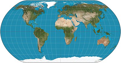
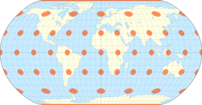
Natural Earth projection of the world.The natural Earth projection with Tissot's indicatrix of deformation
The Natural Earth projection is a pseudocylindrical map projection designed by Tom Patterson and introduced in 2008.[1] It is neither conformal nor equal-area, but a compromise between the two.
In its original presentation, the projection's origin is described as "The impetus for creating the Natural Earth projection was dissatisfaction with existing world map projections for displaying physical data." Further criteria follow, ending with "The ideal projection needed to be both functional and rather familiar in appearance."[1]
The Natural Earth projection was originally designed in Flex Projector, a specialized software application that offers a graphical approach for the creation of new projections.[1] Subsequently, Bojan Šavrič developed a polynomial expression of the projection.[2][3]
The projection may also be referred to as the Natural Earth I projection, due to subsequent development of a Natural Earth II projection.[4][5]
^ abcJenny, Bernhard; Patterson, Tom; Hurni, Lorenz (2008). "Flex Projector–Interactive Software for Designing World Map Projections". Cartographic Perspectives (59): 12–27. doi:10.14714/CP59.245. Retrieved May 21, 2023.
^
Šavrič, Bojan (2011). Derivation of a Polynomial Equation for the Natural Earth Projection (Thesis). University of Ljubljana, Slovenia.
^Šavrič, Bojan; Jenny, Bernhard; Patterson, Tom; Petrovič, Dušan; Hurni, Lorenz (February 17, 2012). "A Polynomial Equation for the Natural Earth Projection" (PDF). Oregon State University. Archived from the original (PDF) on 2016-03-03. Retrieved January 24, 2020.
^
Šavrič, Bojan; Patterson, Tom; Jenny, Bernhard (2015). "The Natural Earth II world map projection". Intl. J. Cartogr. 1 (2): 123–133. doi:10.1080/23729333.2015.1093312. S2CID 130666492. Retrieved 2023-05-21.
^"Natural Earth II—ArcGIS Pro | Documentation". pro.arcgis.com. Retrieved 2023-12-21.
and 27 Related for: Natural Earth projection information
The NaturalEarthprojection is a pseudocylindrical map projection designed by Tom Patterson and introduced in 2008. It is neither conformal nor equal-area...
The Equal Earth map projection is an equal-area pseudocylindrical projection for world maps, invented by Bojan Šavrič, Bernhard Jenny, and Tom Patterson...
including modifying the content and design. NaturalEarthprojectionNaturalEarth project website NaturalEarth Contributors Kurgan, Laura (2013). Close...
equidistant projection. The polar azimuthal equidistant projection has also been adopted by 21st century Flat Earthers as a map of the Flat Earth, particularly...
reference surfaces used as models for the Earth, such as oblate spheroids, ellipsoids, and geoids. Since any map projection is a representation of one of those...
The Mercator projection (/mərˈkeɪtər/) is a conformal cylindrical map projection presented by Flemish geographer and cartographer Gerardus Mercator in...
The equirectangular projection (also called the equidistant cylindrical projection or la carte parallélogrammatique projection), and which includes the...
regular icosahedron as the base for the projection. The version most commonly referred to today, it depicts Earth's continents as "one island", or nearly...
In cartography, a conformal map projection is one in which every angle between two curves that cross each other on Earth (a sphere or an ellipsoid) is preserved...
The Winkel tripel projection (Winkel III), a modified azimuthal map projection of the world, is one of three projections proposed by German cartographer...
surface. 360 video projection List of national coordinate reference systems Snake Projection Snyder, John P. (1993). Flattening the Earth: Two Thousand Years...
The Robinson projection is a map projection of a world map that shows the entire world at once. It was specifically created in an attempt to find a good...
Web Mercator or WGS 84/Pseudo-Mercator is a variant of the Mercator map projection and is the de facto standard for Web mapping applications. It rose to...
Astral projection (also known as astral travel, soul journey, soul wandering, spiritual journey, spiritual travel) is a term used in esotericism to describe...
stereographic projection is a perspective projection of the sphere, through a specific point on the sphere (the pole or center of projection), onto a plane...
Perspective projection is a map projection. When the Earth is photographed from space, the camera records the view as a perspective projection. When the...
gnomonic projection, also known as a central projection or rectilinear projection, is a perspective projection of a sphere, with center of projection at the...
the north pole. List of map projections Snyder, John P (1993), Flattening the Earth: Two Thousand Years of Map Projections, pp. 60–2, ISBN 0-226-76747-7...
Goode homolosine projection (or interrupted Goode homolosine projection) is a pseudocylindrical, equal-area, composite map projection used for world maps...
stereographic projection, also known as the planisphere projection or the azimuthal conformal projection, is a conformal map projection whose use dates...
known as the Babinet projection, homalographic projection, homolographic projection, and elliptical projection. The projection trades accuracy of angle...
Orthographic projection in cartography has been used since antiquity. Like the stereographic projection and gnomonic projection, orthographic projection is a...
The transverse Mercator map projection (TM, TMP) is an adaptation of the standard Mercator projection. The transverse version is widely used in national...
satellite's long-term movement around the Earth in a continuous line. In 2011 the AuthaGraph mapping projection was selected by the Japanese National Museum...
Terrestrial and Celestial Maps). Conceptually, the projection conformally maps the surface of the Earth to a cone. The cone is unrolled, and the parallel...
Albers equal-area conic projection, or Albers projection (named after Heinrich C. Albers), is a conic, equal area map projection that uses two standard...
The central cylindrical projection is a perspective cylindrical map projection. It corresponds to projecting the Earth's surface onto a cylinder tangent...
 Global Information