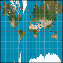
The central cylindrical projection with a 15° graticule, approximately to latitude ±72°. Distortion is noticeably worse than that of the Mercator projection.
The central cylindrical projection is a perspective cylindrical map projection. It corresponds to projecting the Earth's surface onto a cylinder tangent to the equator as if from a light source at Earth's center. The cylinder is then cut along one of the projected meridians and unrolled into a flat map.[1]
The projection is neither conformal nor equal-area. Distortion increases so rapidly away from the equator that the central cylindrical is only used as an easily understood illustration of projection, rather than for practical maps.[1] Its vertical stretching is even greater than that of the Mercator projection, whose construction method is sometimes erroneously described equivalently to the central cylindrical's. The scale becomes infinite at the poles.[2] It is not known who first developed the projection, but it appeared with other new cylindrical projections in the 19th century, and regularly finds its way into textbooks, chiefly to illustrate that this is not the way the Mercator is constructed.[1] As with any cylindrical projection, the construction can be generalized by positioning the cylinder to be tangent to a great circle of the globe that is not the equator.[1]
This projection has prominent use in panoramic photography, where it is usually called the "cylindrical projection". It can present a full 360° panorama and preserves vertical lines. Unlike other cylindrical projections, it gives correct perspective for tall objects, an important trait for architectural scenes.
^ abcdFlattening the Earth: Two Thousand Years of Map Projections, John P. Snyder, Chicago University Press, 1993, pp. 106–107, ISBN 0-226-76747-7.
^World Maps and Globes, Irving Fisher and O. M. Miller, Essential Books, 1944, p. 46.
and 24 Related for: Central cylindrical projection information
The centralcylindricalprojection is a perspective cylindrical map projection. It corresponds to projecting the Earth's surface onto a cylinder tangent...
between the various "natural" cylindricalprojections. But the term cylindrical as used in the field of map projections relaxes the last constraint entirely...
The Mercator projection (/mərˈkeɪtər/) is a conformal cylindrical map projection presented by Flemish geographer and cartographer Gerardus Mercator in...
The Miller cylindricalprojection is a modified Mercator projection, proposed by Osborn Maitland Miller in 1942. The latitude is scaled by a factor of...
The equirectangular projection (also called the equidistant cylindricalprojection or la carte parallélogrammatique projection), and which includes the...
possible map projections, there can be no comprehensive list. *The first known popularizer/user and not necessarily the creator. Cylindrical In normal aspect...
The Gall stereographic projection, presented by James Gall in 1855, is a cylindricalprojection. It is neither equal-area nor conformal but instead tries...
traits from the normal Mercator: Both projections are cylindrical: for the Normal Mercator, the axis of the cylinder coincides with the polar axis and the...
The Winkel tripel projection (Winkel III), a modified azimuthal map projection of the world, is one of three projections proposed by German cartographer...
The Behrmann projection is a cylindrical equal-area map projection described by Walter Behrmann in 1910. Cylindrical equal-area projections differ by their...
only maps based on the Gall–Peters projection, a similar cylindrical equal-area projection, or the AuthaGraph projection, beginning in the 2024–2025 school...
which reduced scale errors to 1/50. Mercator projection (conformal cylindricalprojection) Mercator projection of normal aspect (Every rhumb line is drawn...
trigonometric identities. In cylindrical coordinates (r, θ, z) on the sphere and polar coordinates (R, Θ) on the plane, the projection and its inverse are (...
Lambert cylindrical equal-area projection. List of map projections Stereographic projection in cartography Snyder, J. P. (1987). Map Projections—A Working...
The Robinson projection is a map projection of a world map that shows the entire world at once. It was specifically created in an attempt to find a good...
The Equal Earth map projection is an equal-area pseudocylindrical projection for world maps, invented by Bojan Šavrič, Bernhard Jenny, and Tom Patterson...
The projection represents the poles as points, as they are on the sphere, but the meridians and continents are distorted. The equator and the central meridian...
gnomonic projection, also known as a centralprojection or rectilinear projection, is a perspective projection of a sphere, with center of projection at the...
The Aitoff projection is a modified azimuthal map projection proposed by David A. Aitoff in 1889. Based on the equatorial form of the azimuthal equidistant...
traits from the normal Mercator: Both projections are cylindrical: for the Normal Mercator, the axis of the cylinder coincides with the polar axis and the...
known as the Babinet projection, homalographic projection, homolographic projection, and elliptical projection. The projection trades accuracy of angle...
The azimuthal equidistant projection is an azimuthal map projection. It has the useful properties that all points on the map are at proportionally correct...
they intended to be the same projection.: 60 The Bonne projection maintains accurate shapes of areas along the central meridian and the standard parallel...
 Global Information