Equirectangular projection of the world; the standard parallel is the equator (plate carrée projection).Equirectangular projection with Tissot's indicatrix of deformation and with the standard parallels lying on the equatorTrue-colour satellite image of Earth in equirectangular projectionHeight map of planet Earth at 2km per pixel, including oceanic bathymetry information, normalized as 8-bit grayscale. Because of its easy conversion between x, y pixel information and lat-lon, maps like these are very useful for software map renderings.
The equirectangular projection (also called the equidistant cylindrical projection or la carte parallélogrammatique projection), and which includes the special case of the plate carrée projection (also called the geographic projection, lat/lon projection, or plane chart), is a simple map projection attributed to Marinus of Tyre, who Ptolemy claims invented the projection about AD 100.[1]
The projection maps meridians to vertical straight lines of constant spacing (for meridional intervals of constant spacing), and circles of latitude to horizontal straight lines of constant spacing (for constant intervals of parallels). The projection is neither equal area nor conformal. Because of the distortions introduced by this projection, it has little use in navigation or cadastral mapping and finds its main use in thematic mapping. In particular, the plate carrée has become a standard for global raster datasets, such as Celestia, NASA World Wind, the USGS Astrogeology Research Program, and Natural Earth, because of the particularly simple relationship between the position of an image pixel on the map and its corresponding geographic location on Earth or other spherical solar system bodies. In addition it is frequently used in panoramic photography to represent a spherical panoramic image.[2]
^Flattening the Earth: Two Thousand Years of Map Projections, John P. Snyder, 1993, pp. 5–8, ISBN 0-226-76747-7.
The equirectangularprojection (also called the equidistant cylindrical projection or la carte parallélogrammatique projection), and which includes the...
18 July 1953) in 1921. The projection is the arithmetic mean of the equirectangularprojection and the Aitoff projection: The name tripel (German for...
concluded using cartometric analysis that these charts used an equirectangularprojection instead. Portuguese mathematician and cosmographer Pedro Nunes...
somewhat similar to an equirectangularprojection. Fuller projection Dymaxion-like conformal projection Comparison of the Fuller projection and Strebe's Dymaxion-like...
representation, transmission, and display of 360° fields of view. An equirectangularprojection simply maps the yaw and pitch (longitude and latitude) of a sphere...
This is a summary of map projections that have articles of their own on Wikipedia or that are otherwise notable. Because there is no limit to the number...
known as the Babinet projection, homalographic projection, homolographic projection, and elliptical projection. The projection trades accuracy of angle...
isographic projection is a specific instance of equirectangularprojection such that its standard parallels are north and south 45°. The projection is named...
the equirectangularprojection, in that the globe is first rotated so the central meridian becomes the "equator", and then the normal equirectangular projection...
The Equal Earth map projection is an equal-area pseudocylindrical projection for world maps, invented by Bojan Šavrič, Bernhard Jenny, and Tom Patterson...
sphere, for example, the modeller might transform it into an equirectangularprojection. Once the model is unwrapped, the artist can paint a texture on...
sinusoidal projection is a pseudocylindrical equal-area map projection, sometimes called the Sanson–Flamsteed or the Mercator equal-area projection. Jean Cossin...
Historically the first projection, invented by Marinus of Tyre ca. AD 100 according to Ptolemy, was what is now called equirectangularprojection (historically...
his geographical treatise however is lost. He also invented the equirectangularprojection, which is still used in map creation today. A few of Marinus'...
Winkel projections use the arithmetic mean of the equirectangularprojection and other projections. There are several variants: the Winkel I projection uses...
the panosphere. Spherical projection or equirectangularprojection — which is strictly speaking another cylindrical projection — where the stitched image...
The Robinson projection is a map projection of a world map that shows the entire world at once. It was specifically created in an attempt to find a good...
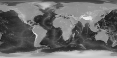
Heightmap of Earth's surface (including water and ice) in equirectangularprojection, normalized as 8-bit grayscale, where lighter values indicate higher...
The Aitoff projection is a modified azimuthal map projection proposed by David A. Aitoff in 1889. Based on the equatorial form of the azimuthal equidistant...
of Earth's surface (including water and ice), rendered as an equirectangularprojection with elevations indicated as normalized 8-bit grayscale, where...
sphere may then be projected to the plane with an equirectangularprojection to give a double projection from the ellipsoid to the plane such that all meridians...
gnomonic projection, also known as a central projection or rectilinear projection, is a perspective projection of a sphere, with center of projection at the...
Goode homolosine projection (or interrupted Goode homolosine projection) is a pseudocylindrical, equal-area, composite map projection used for world maps...
 Global Information