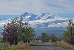
Mount Aragats (Armenian: Արագած, pronounced[ɑɾɑˈɡɑt͡s]) is an isolated four-peaked volcano massif in Armenia. Its northern summit, at 4,090 m (13,420 ft) above sea level, is the highest point of the Lesser Caucasus and Armenia. It is also one of the highest points in the Armenian Highlands.[a]
The Aragats massif is surrounded by the Kasagh River on the east, the Akhurian River on the west, Ararat Plain on the south, and Shirak Plain on the north.[2] The circumference of the massif is around 200 km (120 mi),[10][9] and covers an area of 6,000 km2 (2,300 sq mi)[11] or around 1⁄5 of Armenia's total area.[b] 944 km2 (364 sq mi) of the massif is located above 2,000 m (6,600 ft).[13]
^ abcCite error: The named reference gvp was invoked but never defined (see the help page).
^ abCite error: The named reference cadastre was invoked but never defined (see the help page).
^"High prominence mountains in Caucasus and Russia outside of Europe". ii.uib.no. Institutt for informatikk University of Bergen.
^Ketchian, Philip K. (December 24, 2005). "Climbing Ararat: Then and Now". The Armenian Weekly. 71 (52). Archived from the original on September 8, 2009.
^Cite error: The named reference armgeo was invoked but never defined (see the help page).
^Aslani︠a︡n, A. T. (1973). "Yerevan-Southern Summit of Aragats Volcano". Guide-book of Excursions of the All-union Conference for the Study of the Quaternary Period: Armenian SSR. Academy of Sciences of the Armenian SSR Institute of Geological Sciences. p. 72. By its height among the highest peaks of the Armenian highland Aragats gives way only to Ararat — the famous biblical mountain that rises for more than 1 km.
^Hewsen, Robert H.; Anania Shirakatsi (1992). The Geography of Ananias of Širak: Ašxarhacʻoycʻ, the Long and the Short Recensions. Reichert. p. 217. ISBN 9783882264852. The highest peak in the Armenian SSR, Aragac is the third highest mountain on the Armenian plateau after Ararat (16,916 ft. /5172 m), and Sip'an (Subhan, 14,543/4434).
^Smith, Adam T. (2009). "Regional Investigations in the Tsaghkahovit Plain: Orientation and Methodology". The Foundations of Research and Regional Survey in the Tsaghkahovit Plain, Armenia. Oriental Institute of the University of Chicago. p. 95. ISBN 9781885923622. Aragats is the third highest peak in the Armenian Highland after Great Ararat (5,165 m a.s.l.) and Süphan Dağı (4,434 m a.s.l.).
^ abCite error: The named reference Nazarian was invoked but never defined (see the help page).
^Adalian 2010, p. 3.
^Cite error: The named reference encyclopedia.am was invoked but never defined (see the help page).
^"Armenia". The World Factbook. Central Intelligence Agency.
^Martirosyan 2013, p. 127.
Cite error: There are <ref group=lower-alpha> tags or {{efn}} templates on this page, but the references will not show without a {{reflist|group=lower-alpha}} template or {{notelist}} template (see the help page).
MountAragats (Armenian: Արագած, pronounced [ɑɾɑˈɡɑt͡s]) is an isolated four-peaked volcano massif in Armenia. Its northern summit, at 4,090 m (13,420 ft)...
land of rugged mountains and extinct volcanoes, its highest point is MountAragats, 13,435 ft (4,095 m). Javakheti mountain range Armeno-Georgian mountain...
cold winters. The land rises to 4,090 m (13,420 ft) above sea-level at MountAragats. Armenia is located in the southern Caucasus, the region southwest of...
is home to the "Ashtarak Dzu" poultry farm, while the Aragats village is home to the "Aragats Poultry farm". Aragatsotn has a poor industrial structure...
by the Armenian Academy of Sciences. It is located on the slope of MountAragats in the village of Byurakan in Armenia. Founded in 1946 by Viktor Hambardzumyan...
of Portugal on mainland Europe, but the highest peak of the country is Mount Pico in the Azores islands, which are usually considered part of Europe...
'Rock/Mountain Lake') is a freshwater lake in Armenia located on the slopes of MountAragats. It is located 3,185 m above sea level and has a perimeter of 1,150 m...
lives. Yazidis are concentrated primarily in agricultural areas around MountAragats, northwest of Yerevan. They live in 19 villages in the Aragatsotn Province...
foothills of the Gegham mountains. In the north, the plain borders on MountAragats, and Mount Ararat in the south. It is divided into two sections by the Aras...
Armenian Republic. One column captured Alexandropol and marched north of MountAragats, where eighty Yezidis were massacred at Kurdsky Pamb, towards the Transcaucasian...
an "ancient rock-carved fortress", the towers of which are Ararat and Aragats. English Romantic poet William Wordsworth imagines seeing the ark in the...
Mount Elbrus is the highest mountain in Russia and Europe. It is situated in the western part of the North Caucasus and is the highest peak of the Caucasus...
Municipality of the Aragatsotn Province of Armenia, located on the slope of MountAragats. The village is home to several historical sites including the 7th-century...
geographically more connected to the mountains of West Asia. Two of these peaks (MountAragats and Kapudzhukh Lerr) are on the Asian side of the ridge of the Greater...
3543611; -65.02528 Aragatsotn Province: On the road to Lake Kari, on MountAragats. coordinates: 40°26′10″N 44°13′40.50″E / 40.43611°N 44.2279167°E...
forests. The land rises to 4,090 metres (13,419 feet) above sea level at MountAragats, and no point is below 390 metres (1,280 ft) above sea level. Average...
modern texts. Ark of Nuh or Noah İlandağ in Nakhchivan, Azerbaijan "MountAragats | mountain, Armenia". Britannica.com. Archived from the original on...
of Armenia. Located in the Ararat plain dominated by Mount Ararat from the south and MountAragats from the north, the province's capital is the town of...
fortress located 2,300 meters (7,500 ft) above sea level, on the slopes of MountAragats at the confluence of the Arkashen and Amberd rivers in the province...
Similarly, there are irrigation systems found by Ashkharbek Kalantar at MountAragats, the Tokhmakagan backwaters of the Gegham mountains, Artanish Bay and...
villages and rise sharp against the background of the mountains crowned by MountAragats. The monastic structures erected by Prince Vache Vachutyan, the Church...
Armenian monastery and church located on the southeastern slopes of MountAragats near the modern village of Tegher, and across the gorge from the village...
thrust fault on the slopes of the Lesser Caucasus mountains north of MountAragats. The mainshock produced surface rupture and propagated to the west with...
 Global Information