Mono River mouth area in Grand-Popo area, Benin.Togo with the Oti River (north) and the Mono River (south)
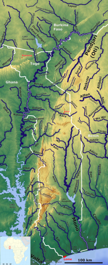
The Mono River is the major river of eastern Togo.
Approximately 400 km (250 mi) long, and draining a basin of about 20,000 km2 (7,700 sq mi), it rises between the town of Sokodé and the border with Benin, and flows south. Along the southern portion of the river towards its mouth, it forms the international boundary between Togo and Benin. The river drains into the Bight of Benin through an extensive system of brackish water lagoons and lakes, including Lake Togo.[1] Only the part of the river nearest its mouth is navigable. Most of the river's basin on the upper tableland is cultivated for maize, yams, rice, cotton and cassava.[2]
The river is dammed 160 km (99 mi) from its mouth by the Nangbeto Dam, a partnership between Benin and Togo completed in 1987. Studies have reported economic benefits from the dam, including tourism and fishing in the lake behind it. The dam's construction displaced between 7,600 and 10,000 people, however, and studies indicate that it has substantially modified the ecology of the lagoon system at the river's mouth by reducing the natural seasonal fluctuations in river flow. A second dam project, Adjarala Dam, was proposed to be built on the river between Nangbeto and the river's mouth during the 1990s[3] but did not receive financing until 2017 when the China-Africa Development Fund agreed to support the project.[4] The dam's construction is part of the government's plan to increase Benin's domestic power generation capacity from 20 to 70% as most of Togo and Benin's electricity currently needs to be imported from the Akosombo Dam in Ghana.[5]
About 35 km (22 mi) from its mouth, there are six series of rapids. Below this, the river becomes slow-moving and flows over a swampy floodplain, and there is a large area of contiguous wetland in both Togo and Benin. This area has a rich growth of reeds, sedges and grasses, and manatees, crocodiles and hippopotamus occur in the river.[6]
^Philip's (1994). Atlas of the World. Reed International. p. 101. ISBN 0-540-05831-9.
^"Mono River". Encyclopædia Britannica. Encyclopædia Britannica. Retrieved 21 November 2016.
^"Multinational: Nangbeto Hydroelectric Dam (Benin/Togo)". African Development Bank Group. 15 January 2014. Retrieved 21 November 2016.
^Togo First, Togo: CAD Fund to support new development projects , Tuesday, 11 September 2018 19:08 , https://www.togofirst.com/en/investments/1109-1578-togo-cad-fund-to-support-new-development-projects
^Europa Publications (2014). Africa South of the Sahara 2014. Routledge. p. 112. ISBN 978-1-85743-698-3.
^Hughes, R.H. (1992). A Directory of African Wetlands. IUCN. p. 443. ISBN 978-2-88032-949-5.
The MonoRiver is the major river of eastern Togo. Approximately 400 km (250 mi) long, and draining a basin of about 20,000 km2 (7,700 sq mi), it rises...
Look up mono, Mono, mono-, or -mono in Wiktionary, the free dictionary. Mono may refer to: Infectious mononucleosis, "the kissing disease" Monocyte, a...
Mono Lake (/ˈmoʊnoʊ/ MOH-noh) is a saline soda lake in Mono County, California, formed at least 760,000 years ago as a terminal lake in an endorheic basin...
the Owens River Valley; the San Joaquin Valley and foothills areas, especially Fresno County; and in the San Francisco Bay Area. The "Mono" lived on both...
Olympio. The order is named after the major river passing through the country: the MonoRiver. The Order of Mono consists of five grades, awarded to both...
migrated to southern Benin in the 12th or 13th century from Tado on the MonoRiver, and c. 1600, three brothers, Kokpon, Do-Aklin, and Te-Agbanlin, split...
the Mont Agou at 986 metres (3235') above sea level. The longest river is the MonoRiver with a length of 400 km (250 miles). It runs from north to south...
the 2009 population of Mono County was about 12,927 while Inyo County had some 17,293 inhabitants. The largest city on the river is Bishop, with a population...
The Mono Basin is an endorheic drainage basin located east of Yosemite National Park in California and Nevada. It is bordered to the west by the Sierra...
Mono is one of the twelve departments of Benin, with its capital at Lokossa. It is named for the MonoRiver which forms much of the border with Togo....
just west of Lokoja and continues unbroken up to the Ogooué River tributary of the MonoRiver in Togo, a distance of around 610 km. In the south, it begins...
founded by a group of Aja migrants from Tado, a settlement along the MonoRiver, in the 12th or 13th century. Its kings "ruled with the consent of the...
(/ˈeɪ.weɪ/; Ewe: Eʋeawó, lit. "Ewe people"; or Mono Kple Volta Tɔ́sisiwo Dome, lit. "Between the RiversMono and Volta"; Eʋenyígbá Eweland;) are a Gbe-speaking...
electricity, although the construction of the Adjarala Dam (on Togo's MonoRiver) hopes to reduce these countries' reliance on imported electricity. The...
Togbadji is a small lake in Mono Department, Benin. The lake has a surface area of about 5.5km2 and is on the MonoRiver. The lake is fished for the Mango...
Volta River (Ghana) Oti River Kara River Pendjari RiverMonoRiver Couffo River (Kouffo River) Ouémé River Zou River Agbado River Okpara River Alpouro...
They settled in the ancient kingdom of Tado (also Stado or Stádó) on the Monoriver (in present-day Togo). The Tado kingdom was an important state in West...
languages called Mono: Mono language (California), an endangered Native American language of the California River basin in the United States Mono language (Cameroon)...
northwestern Mono County, north of Yosemite National Park in the Toiyabe National Forest. It flows north, joining the West Walker River from the south...
and the Kara Region in the country of Togo, close to the source of the MonoRiver. It is located 58 kilometres (36 mi) from the town of Bassila. The hill...
eastern edge of the Sierra Nevada mountains in southern Mono County, along the stretch of the river where it exits the Long Valley near its source and enters...
the Great Basin. The East Walker River rises from snow melt in the Sierra Nevada of eastern California north of Mono Lake and near the northeast boundary...
The Mono Grande (Spanish for "Large Monkey"), a large monkey-like creature, has been occasionally reported in South America. Such creatures are reported...
of 48,000 acre⋅ft (59,000,000 m3), the 12.7 mi (20.4 km) Mono Craters Tunnel to the Owens River, and a second reservoir, later named Crowley Lake with a...
federally recognized Mono tribes are the Tule River Indian Tribe of the Tule River Reservation, Cold Springs Rancheria of Mono Indians of California...
640 ft) above sea level. The area is drained by the MonoRiver and its tributaries, including the Ogou River. To the west and the southwest of the tableland...
 Global Information