Spring Valley Wash, Silver Canyon Creek, Coldwater Canyon Creek
• right
Hot Creek, Rock Creek, Bishop Creek, Big Pine Creek, Birch Creek, Independence Creek, Lone Pine Creek
National Wild and Scenic River
Designated
March 30, 2009
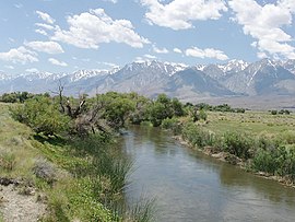
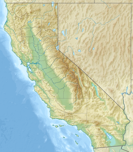
The Owens River is a river in eastern California in the United States, approximately 183 miles (295 km) long.[4] It drains into and through the Owens Valley, an arid basin between the eastern slope of the Sierra Nevada and the western faces of the Inyo and White Mountains. The river terminates at the endorheic Owens Lake south of Lone Pine, at the bottom of a 2,600 sq mi (6,700 km2) watershed.
In the early 1900s, the Owens River was the focus of the California Water Wars, fought between the city of Los Angeles and the inhabitants of Owens Valley over the construction of the Los Angeles Aqueduct. Since 1913, the Owens River has been diverted to Los Angeles, causing the ruin of the valley's economy and the drying of Owens Lake. In winter 2006, the Los Angeles Department of Water and Power restored 5% of the pre-aqueduct flow to the river by court order, allowing the Owens River Gorge, the river bed in the valley, and Owens Lake to contain a small amount of water.[5]
^"Query Form For The United States And Its Territories". U.S. Board on Geographic Names. Retrieved 2010-05-13.
^ abc"Owens River". Geographic Names Information System. United States Geological Survey, United States Department of the Interior. 1981-01-19. Retrieved 2010-06-05.
^ ab"USGS Gage #10227500 on the Owens River near Big Pine, CA". National Water Information System. U.S. Geological Survey. 1975-12-19. Retrieved 2011-12-15.
^U.S. Geological Survey. National Hydrography Dataset high-resolution flowline data. The National Map, accessed March 17, 2011,
^"L.A. Returns Water to the Owens Valley". NPR.org. NPR
The OwensRiver is a river in eastern California in the United States, approximately 183 miles (295 km) long. It drains into and through the Owens Valley...
Owens Lake is a mostly dry lake in the Owens Valley on the eastern side of the Sierra Nevada in Inyo County, California. It is about 5 miles (8.0 km) south...
617325°W / 37.574515; -118.617325 The OwensRiver Gorge is a steep 10 mi (16 km) canyon on the upper OwensRiver in eastern California in the United States...
Owens Valley (Mono: Payahǖǖnadǖ, meaning "place of flowing water") is an arid valley of the OwensRiver in eastern California in the United States. It...
500 metres (4,900 ft) thick in the caldera floor, and is cut by the OwensRiver Gorge, formed during the Pleistocene when the caldera filled with water...
Kawaiisu allies in the Owens Valley of California and the southwestern Nevada border region. The removal of a large number of the OwensRiver indigenous Californians...
Nevada in the Owens Valley (Mono: Payahǖǖnadǖ/Payahuunadu – "place/land of flowing water") along the OwensRiver (Wakopee) and south to Owens Lake (Pacheta)...
The OwensRiver Headwaters Wilderness is a wilderness area inside the Inyo National Forest in eastern California designated to protect the headwaters...
Aqueduct effectively eliminated the Owens Valley as a viable farming community and eventually devastated the Owens Lake ecosystem. A group labeled the...
900 km2) and the north portion of the Owens Lake Watershed (USGS HUC 18090103) of 1,340 sq mi (3,500 km2). "Upper OwensRiver Basin" (PDF). Planning Division:...
lake received water mainly from the Amargosa River and at various points from the Mojave River and OwensRiver. The lake and its substantial catchment favoured...
"Buck" Owens Jr. (August 12, 1929 – March 25, 2006) was an American musician, singer, songwriter, and band leader. He was the lead singer for Buck Owens and...
The OwenRiver is located in the northwest of New Zealand's South Island. This short river is an upper tributary of the Buller River. It flows 20 km (12 mi)...
the Owens Valley Indian War. Many settlers came to the area for the promise of riches from mining. The availability of water from the OwensRiver made...
Bishop Tuff outflow sheet. Erosion of the plateau by the OwensRiver has carved the OwensRiver Gorge.: 2 The Bishop Tuff is a high-silicate rhyolitic...
Crowley Lake is a reservoir on the upper OwensRiver in southern Mono County, California, in the United States. Crowley Lake is 15 mi (24 km) south of...
significant alkaline dust during periods of high winds. Owens Lake, the once-navigable terminus of the OwensRiver which had sustained a healthy ecosystem, is now...
"Could the River Thames be longer than the River Severn?". BBC News. "CERC Science Topic: Missouri River" (PDF). infolink.cr.usgs.gov. "Owens Valley Particulate...
Richard Lemon Owings (1812–1902), more commonly known as "Richard Owens" or "Dick Owens", was a pioneer of the American West who played an important role...
Mill Creeks flow into Mono Lake; and the OwensRiver into dry Owens Lake. Although none of the eastern rivers reach the sea, many of the streams from Mono...
above the Owens Valley, sitting 10,778 feet (3,285 m) or just over 2 mi (3.2 km) above the town of Lone Pine 15 mi (24 km) to the east, in the Owens Valley...
Tule River, Kings River, OwensRiver, Monache Cajon and other scattered bands of Indians. While the Tule River Indian Tribe includes Owens valley Paiutes...
the Colorado River, so decided to take all available water from the Owens Valley.: 89 By exploiting personal bitterness of some of the Owens Valley farmers...
glassworks, Corning Glass Works and Owens-Illinois. The company employs approximately 19,000 people around the world. Owens Corning has been a Fortune 500...
The Owens tui chub (Siphateles bicolor snyderi) was described in 1973 as a subspecies of tui chub endemic to the OwensRiver Basin in Eastern California...
the Owens Valley of California, occurring in most water bodies between Fish Slough and Lone Pine, which are 70 miles apart. It occurred in the Owens River...
with Mono Lake, in the north, and continued through basins down the OwensRiver Valley, through Searles and China Lakes and the Panamint Valley, to the...
 Global Information