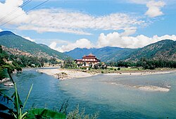
Confluence of the Mo Chhu (left) and the Pho Chhu (right)
Location
Country
Bhutan
Physical characteristics
Source
• location
Gasa District
Mouth
• location
Brahmaputra
Mo Chhu is a major river in Bhutan. The word "Chhu" means "river" or "water" in Dzongkha, the official national language in Bhutan. The river rises in Gasa Dzongkhag (district) near the border between Bhutan and Tibet. From there, the Mo Chhu flows generally southward to Punakha in central Bhutan, where it joins the Pho Chhu from the northeast. The confluence of the two streams is immediately below the Punakha Dzong, which is the winter home of the Dratshang Lhentshog (Central Monk Body) and the Je Khenpo.
The combined streams are then joined by the Dang Chhu near the town of Wangdue Phodrang, and the name of the river becomes the Puna Tsang Chhu. The river then flows through Dagana and Tsirang Districts. After leaving Bhutan near the town of Lhamoidzingkha, formerly known as Kalikhola,[1] the river enters Assam in India and is known as the Sankosh. The Sankosh ultimately empties into the Brahmaputra, flowing into the Bay of Bengal.
^From Damphu to Lhamoidzingkha, in the Bhutanese daily "Kuensel", 21 May 2020 https://kuenselonline.com/from-damphu-to-lhamoidzingkha/
MoChhu is a major river in Bhutan. The word "Chhu" means "river" or "water" in Dzongkha, the official national language in Bhutan. The river rises in...
the town of Wangdue Phodrang. The two largest tributaries are the MoChhu and Pho Chhu, which flow together at Punakha. The Punakha dzong, which is situated...
a flood in 1994. Due to its location at the confluence of the Pho Chhu and MoChhu rivers in the Punakha-Wangdue valley, the dzong is vulnerable to flash...
Dzong is located between the Pho Chhu (Male) and MoChhu (Female) river in the Punakha–valley. The source of the Mo chu river is in the northern hills...
joins with the MoChhu (Female River) at the confluence below Punakha Dzong, the winter residence of Dratshang Lhentshog. Upon Dang Chhu joining below...
century, it is located between the confluence of two rivers: Pho Chhu (male) and MoChhu (female). Khamsum Yulley Namgyal Choeten Punakha District is divided...
the MoChhu in western Bhutan. It originates in the Himalayas near Thowadra Gompa. It receives numerous hill streams, including the Yenyer Chhu. It joins...
Drangme Chhu is called the Manas Chhu. The 320-kilometre-long (200 mi) Puna Tsang Chhu rises in northwestern Bhutan as the MoChhu and Pho Chhu, which...
Di Chu Amo Chhu or Torsa Wong Chhu or Raidak Ha Chhu Paro Chhu Thimphu Chhu/Wang Chhu Puna Tshang Chhu or Sankosh River Pho ChhuMoChhu Tang Chuu. Manas...
the courtyard with further staircases up to them. Punakha Dzong and the MoChhu Simtokha Dzong near Thimphu Courtyard and tower of Rinpung Dzong at Paro...
exceptionally scenic location of its Dzong. In 2008 a massive flood on the MoChhu (Female River) destroyed a popular hot spring complex, which is under restoration...
region form a watershed between two major river systems: the MoChhu and the Drangme Chhu. Peaks in the Black Mountains range between 1,500 and 4,925 m...
Wang Chhu basin (consisting of Pa Chhu, Ha Chhu and Thim Chhu sub basins), Punatshang Chhu basin (consisting of Pho Chhu, MoChhu and Dang Chhu sub basins)...
form a watershed between two major river systems, the MoChhu (Sankosh River) and the Drangme Chhu. Central valleys are separated from the east by the Donga...
Dzong are sites of historical importance. The rivers MoChhu, Wangdi Chhu and Pa Chhu (Paro Chhu) have their sources in the glacial lakes located in the...
The MoChhu drains the northern and western flanks, while precipitation on the eastern flank flows into the western headwaters of the Pho Chhu. About...
dates back to the 1960s when primitive settlement formed from the banks of MoChhu to the present area, which used to be known as Hati Sahar (Elepan elephant-sted...
Bhutan form a watershed between two major river systems, the MoChhu and the Drangme Chhu. Peaks in the Black Mountains range between 1,500 metres (4,900 ft)...
This lake feeds into the MoChhu (River) basin. Sinchhe Glacial Lake Gasa District Laya Gewog Sinchhe drains into the MoChhu (River) basin. Gangchentag...
Bhutan (Dzongkha: འབྲུག་གི་རྩ་ཁྲིམས་ཆེན་མོ་; Wylie: 'Druk-gi cha-thrims-chen-mo) was enacted 18 July 2008 by the Royal Government of Bhutan. The Constitution...
glacier into a lake in 1958 created a devastating wave that swept the Mo-Chhu River for miles, taking with it the tree trunks that destroyed the cantilever...
well-built houses." White 1971, p. 112: "At Rinchengong the road crossed the Am-mo-chhu [Amo Chu] by a substantial bridge, and our path opened out most lovely...
northern Bhutan. The mountain peak is located in the catchment area of the MoChhu in Jigme Dorji National Park. The peak is 1.3 km south of the main Himalayan...
a sub-urban area in the northeast of Singapore, with proximity to the Ang Mo Kio, Lentor, Seletar and Sengkang areas. Deriving its name from the Yio Chu...
sea level 76 m 249 ft Bhutan Gangkhar Puensum 7570 m 24,836 ft Drangme Chhu 97 m 318 ft 7473 m 24,518 ft Bir Tawil Gabal Hagar El Zarqa 662 m 2,172 ft...
 Global Information