 Global Information
Mountains of Bhutan information
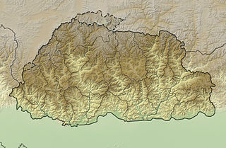
The mountains of Bhutan are some of the most prominent natural geographic features of the kingdom. Located on the southern end of the Eastern Himalaya, Bhutan has one of the most rugged mountain terrains in the world, whose elevations range from 160 metres (520 ft) to more than 7,000 metres (23,000 ft) above sea level, in some cases within distances of less than 100 kilometres (62 mi) of each other. Bhutan's highest peak, at 7,570 metres (24,840 ft) above sea level, is north-central Gangkhar Puensum,[1] close to the border with Tibet; the third highest peak, Jomolhari, overlooking the Chumbi Valley in the west, is 7,314 metres (23,996 ft) above sea level; nineteen other peaks exceed 7,000 metres (23,000 ft).[2] Weather is extreme in the mountains: the high peaks have perpetual snow, and the lesser mountains and hewn gorges have high winds all year round, making them barren brown wind tunnels in summer, and frozen wastelands in winter. The blizzards generated in the north each winter often drift southward into the central highlands.
The mountains of Bhutan define its three main geographic zones: the Great Himalaya, the Lower Himalayan Range (or Inner Himalaya), and the Sub-Himalayan Range.[3][4] The snowcapped Great Himalaya in the north ranges from about 5,500 metres (18,000 ft) to peaks of over 7,500 metres (24,600 ft) above sea level, extending along the Bhutan-Tibet border. The northern region consists of an arc of glaciated mountain peaks with an arctic climate at the highest elevations. Watered by snow-fed rivers, alpine valleys in this region provide pasturage for livestock tended by a sparse population of migratory shepherds.[2] Spur-like mountain ranges of the Lower Himalaya, between 1,500 metres (4,900 ft) and 5,500 metres (18,000 ft), run northwest to southeast in western Bhutan, and northeast to southwest in eastern Bhutan.[5] These mountains, and especially their western valleys, make up the economic and cultural heart of the kingdom, including most of its dzongs. These mountainous areas are contrasted with the hilly Sub-Himalaya, with elevations of up to 1,500 metres (4,900 ft), and the lower Duars.[3] Many lower mountain ranges are composed of coarse granite sandstone, while rocks at the highest elevations consist of gneiss among upheaved strata of mica and talcose slate. Many ranges are abundant in limestone.[5]
Bhutan's valleys are carved into the Himalaya by its rivers, fed by glacial melt and monsoon rains. Much of the Bhutanese population is concentrated in valleys and lowlands, separated by the rugged southward spurs of the Inner Himalaya.[2][6][7][8][9]: 72, 84, 91 Despite modernization and development of transport in Bhutan, including a national highway system, travel from one valley to the next remains difficult.[10] Western valleys are bound to the east by the Black Mountains in central Bhutan, which form a watershed between two major river systems, the punatsangchhu (Sankosh River) and the Drangme Chhu. Central valleys are separated from the east by the Donga Range.[2][11][12] The more isolated mountain valleys protect several tiny, distinct cultural and linguistic groups.[13]
Bhutan controls several strategic Himalayan mountain passes including routes between Tibet and Assam. These routes, being the only way into the kingdom, along with centuries-old policies of isolationism, have gained Bhutan the nickname "Mountain Fortress of the Gods." Although the British established a protectorate over Bhutan and occupied its lowlands, the mountainous interior has never been successfully invaded.[14]
- ^ "Bhutan". World Factbook. CIA. 2011-03-22. Retrieved 2011-04-03.
- ^ a b c d
 This article incorporates text from this source, which is in the public domain. Worden, Robert L (1991). Savada, Andrea Matles (ed.). Bhutan: A Country Study. Federal Research Division. The Land.
- ^ a b Cite error: The named reference
HKBwas invoked but never defined (see the help page). - ^ Cite error: The named reference
Pratap2011was invoked but never defined (see the help page). - ^ a b Cite error: The named reference
Imperialwas invoked but never defined (see the help page). - ^ This article incorporates text from this source, which is in the public domain. Worden, Robert L (1991). Savada, Andrea Matles (ed.). Bhutan: A Country Study. Federal Research Division. Population – Size, Structure, and Settlement Patterns.
- ^ White, John Claude (1909). Sikhim & Bhutan: Twenty-One Years on the North-East Frontier, 1887-1908. E. Arnold. pp. 3–6. Retrieved 2011-10-15.
- ^ Rennie, Frank; Mason, Robin (2008). Bhutan: Ways of Knowing. IAP. p. 58. ISBN 1-59311-734-5. Retrieved 2011-08-10.
- ^ Brown, Lindsay; Armington, Stan (2007). Bhutan (3 ed.). Lonely Planet. pp. 62, 105, 108, 113. ISBN 1-74059-529-7. Retrieved 2011-11-25.
- ^ This article incorporates text from this source, which is in the public domain. Worden, Robert L (1991). Savada, Andrea Matles (ed.). Bhutan: A Country Study. Federal Research Division. Transportation and Communications – Roads.
- ^ This article incorporates text from this source, which is in the public domain. Worden, Robert L (1991). Savada, Andrea Matles (ed.). Bhutan: A Country Study. Federal Research Division. River Systems.
- ^ Kumar, Bachchan (2004). Encyclopaedia of Women in South Asia: Bhutan. Encyclopaedia of Women in South Asia. Vol. 7. Gyan. p. 20. ISBN 81-7835-194-3. Retrieved 2011-10-15.
- ^ Brown, Lindsay; Armington, Stan (2007). Bhutan (PDF). Country Guides (3 ed.). Lonely Planet. pp. 182–183. ISBN 1-74059-529-7. Archived from the original (PDF) on 2011-06-07. Retrieved 2011-10-15.
- ^ Chandra Bisht, Ramesh (2008). International Encyclopaedia of Himalayas. Mittal Publications. p. 28. ISBN 978-81-8324-265-3.