 Global Information
Malabar District information
| Malabar district | |||||||||||||||||||||||||||||||||||||
|---|---|---|---|---|---|---|---|---|---|---|---|---|---|---|---|---|---|---|---|---|---|---|---|---|---|---|---|---|---|---|---|---|---|---|---|---|---|
| District of Madras Presidency | |||||||||||||||||||||||||||||||||||||
| 1792–1956 | |||||||||||||||||||||||||||||||||||||
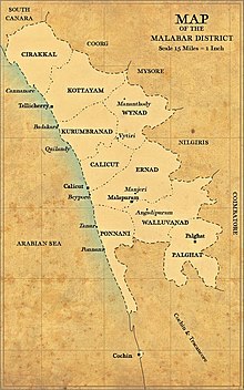 Malabar District with revenue divisions and taluks | |||||||||||||||||||||||||||||||||||||
| Capital | Calicut | ||||||||||||||||||||||||||||||||||||
| Area | |||||||||||||||||||||||||||||||||||||
• 1951 | 15,027[1] km2 (5,802 sq mi) | ||||||||||||||||||||||||||||||||||||
| Population | |||||||||||||||||||||||||||||||||||||
• 1951 | 4,758,842[1] | ||||||||||||||||||||||||||||||||||||
| Government | |||||||||||||||||||||||||||||||||||||
| District collector | |||||||||||||||||||||||||||||||||||||
| History | |||||||||||||||||||||||||||||||||||||
• Territories ceded by Tipu Sultan attached to Bombay Presidency | 1792 | ||||||||||||||||||||||||||||||||||||
• Divided into North Malabar and South Malabar | 1793 | ||||||||||||||||||||||||||||||||||||
• Attached to Madras Presidency | 1800 | ||||||||||||||||||||||||||||||||||||
• Reorganisation of Taluks | 1860 | ||||||||||||||||||||||||||||||||||||
• Transferred Gudalur and Pandalur to Nilgiris | 1877 | ||||||||||||||||||||||||||||||||||||
• Became part of Madras State | 1950 | ||||||||||||||||||||||||||||||||||||
• Kasaragod was added and became part of Kerala | 1956 | ||||||||||||||||||||||||||||||||||||
• Divided into the five districts of Kozhikode, Thrissur, Palakkad, Kannur, and Lakshadweep | 1956 | ||||||||||||||||||||||||||||||||||||
| |||||||||||||||||||||||||||||||||||||
Malabar District, also known as Malayalam District,[1][2] was an administrative district on the southwestern Malabar Coast of Bombay Presidency (1792–1800),[3] Madras Presidency (1800–1937),[4] Madras Province (1937–1950) and finally, Madras State (1950–1956) in India. It was the most populous and the third-largest district in the erstwhile Madras State.[5] The historic town of Calicut (now Kozhikode) was the admisnitrative headquarters of this district.
The district included the present-day districts of Kannur, Kozhikode, Wayanad, Malappuram, Palakkad (excluding Chittur taluk), Chavakad Taluk and parts of Kodungallur Taluk of Thrissur district (former part of Ponnani Taluk), and Fort Kochi area of Ernakulam district in the northern and central parts of present Kerala state, the Lakshadweep Islands, and a major portion of the Nilgiris district in modern-day Tamil Nadu. The detached settlements of Tangasseri and Anchuthengu, which were British colonies within the kingdom of Travancore in southern Kerala, also formed part of Malabar District until 1927.[6]
Malayalam was the administrative as well as the most spoken lingua franca of Malabar district. Jeseri, a distinct dialect of Malayalam, was spoken in the Laccadive Islands. Malabar District merged with the erstwhile state of Travancore-Cochin (1950–1956) to form Kerala according to the States Reorganisation Act, 1956.[7] On the same day, the present Kasaragod district of South Canara District was also attached to Malabar, and the Laccadive and Minicoy Islands of Malabar were reorganised to form a new Union Territory.[7] Malabar was trifurcated to form the districts of Kannur,[8] Kozhikode,[9] and Palakkad,[10] on 1 January 1957.
The city of Kozhikode was the capital of Malabar. Malabar was divided into North Malabar and South Malabar in 1793 for administrative convenience, with their regional headquarters at Thalassery and Cherpulassery (Later changed to Ottapalam) respectively. During the British rule, Malabar's chief importance lay in its production of Malabar pepper, coconut, and tiles.[11] In the old administrative records of the Madras Presidency, it is recorded that the most remarkable plantation owned by Government in the erstwhile Madras Presidency was the Teak plantation at Nilambur planted in 1844.[12] The District of Malabar and the ports at Beypore and Fort Kochi had some sort of importance in the erstwhile Madras Presidency as it was one of the two districts of the Presidency that lies on the Western Malabar Coast, thus accessing the marine route through Arabian Sea. The first railway line of Kerala from Tirur to Beypore in 1861 was laid for it. The work Malabar Manual (1887) authored by William Logan in two volumes explains the characteristics of Malabar.


The district lay between the Arabian Sea on the west, South Canara District on the north, the Western Ghats (the princely states of Coorg and Mysore, and Nilgiris and Coimbatore districts) to the east, and the princely state of Cochin to the south. The district covered an area of 15,027 square kilometres (5,802 sq mi), and extended 233 km (145 mi) along the coast and 40–120 kilometers (25–75 miles) inland. The name Mala-bar means the "hillside slopes".[citation needed]
All the major pre-independence political parties of Kerala such as the INC and CPI started their functioning in Kerala at Malabar District as a part of the freedom struggle. KPCC was formed in 1921 at Ottapalam, on the bank of river Bharathappuzha.[13] In July 1937, a clandestine meeting of the CSP, which was the political party formed by socialists of Congress, was held at Calicut.[14] The CPI in Kerala was formed on 31 December 1939 with the Pinarayi Conference, held near Thalassery.[15] It was the erstwhile leaders of Congress Socialist Party, such as P. Krishna Pillai, K. Damodaran, E. M. S. Namboodiripad, who formed the CPI branch in Kerala. The Indian Union Muslim League was also formed in the 1930s, on a meeting held at Thalassery.
- ^ a b c Cite error: The named reference
Malabarwas invoked but never defined (see the help page). - ^ Cite error: The named reference
Loganwas invoked but never defined (see the help page). - ^ Cite error: The named reference
askhwas invoked but never defined (see the help page). - ^ Chisholm, Hugh, ed. (1911). . Encyclopædia Britannica. Vol. 17 (11th ed.). Cambridge University Press. p. 452.
- ^ Superintendent of Census Operations, Madras (1956). Abstract of 1951 Census Tables for Madras State (PDF). Madras: Government of Madras. p. 6. Archived (PDF) from the original on 3 October 2021. Retrieved 24 November 2020.
- ^ Cite error: The named reference
Malabar and Anjengowas invoked but never defined (see the help page). - ^ a b "The States Reorganisation Act, 1956" (PDF). legislative.gov.in. Government of India. Archived (PDF) from the original on 31 August 2021. Retrieved 9 June 2021.
- ^ M. K. Devassy (1965). 1961 Census Handbook- Cannanore District (PDF). Directorate of Census Operations, Kerala and The Union Territory of Laccadive, Minicoy, and Amindivi Islands. Archived (PDF) from the original on 9 May 2022. Retrieved 9 June 2021.
- ^ M. K. Devassy (1965). 1961 Census Handbook- Kozhikode District (PDF). Directorate of Census Operations, Kerala and The Union Territory of Laccadive, Minicoy, and Amindivi Islands. Archived (PDF) from the original on 26 June 2021. Retrieved 19 December 2020.
- ^ M. K. Devassy (1965). 1961 Census Handbook- Palghat District (PDF). Directorate of Census Operations, Kerala and The Union Territory of Laccadive, Minicoy, and Amindivi Islands. Archived (PDF) from the original on 30 August 2021. Retrieved 9 June 2021.
- ^ Pamela Nightingale, ‘Jonathan Duncan (bap. 1756, d. 1811)’, Oxford Dictionary of National Biography, Oxford University Press, 2004; online edn, May 2009
- ^ Cite error: The named reference
Mbspwas invoked but never defined (see the help page). - ^ "KPCC marks a milestone tomorrow". The Hindu. 21 April 2017. Archived from the original on 9 May 2022. Retrieved 21 April 2017.
- ^ Thiruvananthapuram, R. KRISHNAKUMAR in (26 August 2004). "A man and a movement". Frontline. Archived from the original on 23 April 2022. Retrieved 6 April 2021.
- ^ "Founders". CPIM Kerala. Archived from the original on 8 December 2020. Retrieved 6 April 2021.