South Malabar refers to a geographical area of the southwestern coast of India covering some parts of the present-day Kerala state. South Malabar covers the regions included in present-day Kozhikode taluk of Kozhikode district, the whole area of Malappuram district, Chavakkad taluk of Thrissur district, and Palakkad district, excluding parts of Chittur taluk. The Fort Kochi region of Kochi city also historically belongs to South Malabar. The term South Malabar refers to the region of the erstwhile Malabar District south to the river Korapuzha, and bears a high cultural similarity to both the Cochin (Southern Thrissur region) and the North Malabar regions.[3]
Under British rule, South Malabar's chief importance lay in producing coconut, pepper, and tiles.[4] Old administrative records of the erstwhile Madras Presidency recorded that the most remarkable plantation owned by the government in the Madras Presidency was the teak plantation at Nilambur, planted in 1844.[5] South Malabar held importance as one of the two districts in the Madras Presidency that lay on the western Malabar Coast, thus accessing the marine route through the Arabian Sea via its ports at Beypore and Fort Kochi. The first railway line of Kerala, from Tirur to Beypore, was laid for it.
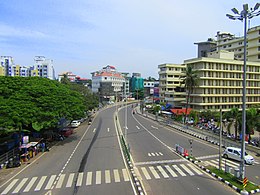
Kozhikode is the capital and largest city of the whole of Malabar, followed by Palakkad. The South Malabar region is bounded by North Malabar (Korapuzha) to north, the hilly region of Nilgiris and Palakkad Gap which connects Coimbatore to east, Cochin to south, and Arabian Sea to west.[6] The historical regions of Nediyiruppu Swaroopam, Eranad, Valluvanad, Parappanad, Kavalappara, Vettathunadu, the Nilambur Kingdom, Nedungadis, and Palakkad, are all included in South Malabar. The longest three rivers of Malabar region, namely the Bharathappuzha, Chaliyar, and Kadalundi Rivers, flow through South Malabar.
^"District Census Handbooks of Kerala - 2011". censusindia.gov.in. Retrieved 26 July 2020.
^"Limits of assembly constituencies of Kerala" (PDF). Keralaassembly.org. Retrieved 26 July 2020.
^Logan, William (2010). Malabar Manual (Volume-I). New Delhi: Asian Educational Services. ISBN 9788120604476.
^Pamela Nightingale, ‘Jonathan Duncan (bap. 1756, d. 1811)’, Oxford Dictionary of National Biography, Oxford University Press, 2004; online edn, May 2009
^Boag, GT (1933). The Madras Presidency (1881-1931)(PDF). Madras: Government of Madras. p. 63.
^Government of Madras (1953). 1951 Census Handbook- Malabar District(PDF). Madras Government Press.
SouthMalabar refers to a geographical area of the southwestern coast of India covering some parts of the present-day Kerala state. SouthMalabar covers...
The Malabar Coast is the southwestern region of the Indian subcontinent. It generally refers to the western coastline of India stretching from Konkan...
Malabar District, also known as Malayalam District, was an administrative district on the southwestern Malabar Coast of Bombay Presidency (1792–1800),...
The Malabar rebellion of 1921 (also called Moplah rebellion, and Mappila rebellion, Malayalam: malabār kalāpam) started as a resistance against the British...
Look up Malabar or malabar in Wiktionary, the free dictionary. Malabar may refer to the following: Malabars, people originating from the Malabar region...
Malabar Hill (ISO: Malabār Hill [mələbaːɾ]) is a hillock and upmarket residential neighbourhood in South Mumbai, Maharashtra, India. Malabar Hill is one...
being part of historical regions of Cochin, North Malabar, SouthMalabar, and Travancore. The North Malabar region, which is culturally distinct from the...
North Malabar region is bounded by Dakshina Kannada (Mangalore) to north, the hilly regions of Kodagu and Mysore Plateau to east, SouthMalabar (Korapuzha)...
Malabar Devaswom Board is a statutory and Independent body created for the governing and management of nearly 1340 temples in SouthMalabar and North...
known for their seafood. South Indian coffee is generally quite robust, and coffee is a preferred drink throughout the Malabar region. Tamil Nadu is well...
and title given to the Thiyya Caste in SouthMalabar. Moopil Nair - Nairs of Palakkad District Achari - south part Ezhuthachan - Malappuram and Thrissur...
SouthMalabar Gramin Bank (Malayalam: സൌത്ത് മലബാർ ഗ്രാമീണ് ബാങ്ക്) Malappuram Kottakunnu (now Kerala Gramin Bank) was a Regional Rural Bank in India...
with managing the Malabar rebellion under British rule. Richard Hitchcock, the district superintendent of police for SouthMalabar at that time, advocated...
formed the Malabar District and built their headquarters at Kozhikode. The headquarters of North Malabar was at Thalassery and that of SouthMalabar was at...
and the southern portion Malabar. The southMalabar or Kerala coast is broken and there are some lagoons. The north Malabar Coast is known as the Karnataka...
Karipur near Kondotty in the Malappuram district of the SouthMalabar region. It serves the Malabar region, consisting of Malappuram, Wayanad and Palakkad...
bank of Bharathappuzha River. Palakkad was included in the SouthMalabar region of Malabar District during the British Raj. The municipality of Palakkad...
remaining 35% stake. The bank was formed by amalgamating North Malabar Gramin Bank and SouthMalabar Gramin Bank on 8 July 2013 by the Ministry of Finance, Government...
rapidly in Malabar and Travancore and Kochi regions, chiefly by the conversion among the lower and 'outcaste' Hindu groups of the SouthMalabar interior...
have arrived on the Malabar coast during the reign of King Solomon. The major metropolitan areas in south India are as follows: South India has an extensive...
University Sadiq Ali Thangal is a member of the Pukkoya family of Panakkad (southMalabar). He is the son of P. M. S. A. Pukkoya Thangal and the younger brother...
of Travancore-Cochin, the Malabar district and the Kasaragod taluk of South Canara District of Madras state. The term Malabar has historically been used...
Mount Malabar (Indonesian: Gunung Malabar) is a stratovolcano, located immediately south of Bandung, West Java, Indonesia. The profile is broad with basaltic...
[koːɻikːoːɖɨ̆] ), also known in English as Calicut, is a city along the Malabar Coast in the state of Kerala in India. It has a corporation limit population...
region and the Mappilas along Malabar region, and the cochin jews and Syriac Nasranis along the southernmost region of South India. The Chola Empire established...
 Global Information