 Global Information
Malappuram district information
Malappuram district | |
|---|---|
District | |
      Clockwise from top: Manjeri town, Biyyam backwater lake at Ponnani, Conolly's plot at Nilambur, Chamravattom Regulator-cum-Bridge, Kadalundi River estuary at Vallikkunnu, Karuvarakundu | |
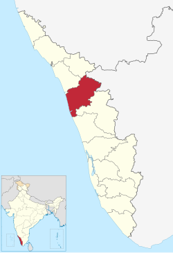 Location in Kerala | |
 | |
| Coordinates: 11°02′N 76°03′E / 11.03°N 76.05°E | |
| Country | |
| State | Kerala |
| District formation | 16 June 1969 |
| Founded by | Government of Kerala |
| Headquarters | Malappuram |
| Sub-divisions |
|
| Government | |
| • Type | District administration |
| • District Collector | V.R. Vinod, IAS[2] |
| • District Police Chief | SASIDHARAN.S IPS[3] |
| Area | |
| • District | 3,554 km2 (1,372 sq mi) |
| • Rank | 3rd |
| Highest elevation (Mukurthi) | 2,594 m (8,510 ft) |
| Population (2018) | |
| • District | 4,494,998[1] |
| • Rank | 1st |
| • Density | 1,265/km2 (3,280/sq mi) |
| • Urban | 44.18%[4] |
| • Metro | 1,729,522[4] |
| Demographics | |
| • Sex ratio (2011) | 1098 ♀/1000♂[4] |
| • Literacy (2011) | 93.57%[4] |
| Time zone | UTC+5:30 (IST) |
| ISO 3166 code | IN-KL |
| Vehicle registration | KL-10 Malappuram, KL-53 Perinthalmanna, KL-54 Ponnani, KL-55 Tirur, KL-65 Tirurangadi, KL-71 Nilambur, KL-84 Kondotty |
| HDI (2005) | |
| Website | malappuram |
Malappuram (Malayalam: [mɐlɐpːurɐm] ⓘ), is one of the 14 districts in the Indian state of Kerala, with a coastline of 70 km (43 mi). The most populous district of Kerala, Malappuram is home to around 13% of the total population of the state. The district was formed on 16 June 1969, spanning an area of about 3,554 km2 (1,372 sq mi). It is the third-largest district of Kerala by area. It is bounded by Western Ghats and the Arabian Sea on either side. The district is divided into seven Taluks: Eranad, Kondotty, Nilambur, Perinthalmanna, Ponnani, Tirur, and Tirurangadi.
Malayalam is the most spoken language. The district has witnessed significant emigration, especially to the Arab states of the Persian Gulf during the Gulf Boom of the 1970s and early 1980s, and its economy depends significantly on remittances from a large Malayali expatriate community.[6] Malappuram was the first e-literate as well as the first cyber literate district of India.[7][8] The district has four major rivers, namely Bharathappuzha, Chaliyar, Kadalundippuzha, and Tirur Puzha, out of which the former three are also included in the five longest rivers in Kerala.
Malappuram metropolitan area is the fourth largest urban agglomeration in Kerala after Kochi, Calicut, and Thrissur urban areas and the 25th largest in India with a total population of 1.7 million.[9] 44.2% of the district's population reside in the urban areas according to the 2011 census of India. Being home to 4 universities in the state which includes the University of Calicut, Malappuram is a hub of higher education in Kerala. The district contains 2 revenue divisions, 7 taluks, 12 municipalities, 15 blocks, 94 Grama Panchayats, and 16 Kerala Legislative Assembly constituencies in it.[10][11][12][13]
During British Raj, Malappuram became the headquarters of European and British troops and it later became the headquarters of the Malabar Special Police (M.S.P), formerly known as Malappuram Special Force formed in 1885, which is also the oldest armed police battalion in the state.[14][15] The oldest Teak plantation of world at Conolly's plot is situated at Chaliyar valley in Nilambur. The oldest Railway line in the state was laid from Tirur to Chaliyam in 1861, passing through Tanur, Parappanangadi, and Vallikkunnu.[16] The second railway line in the state was also laid in the same year from Tirur to Kuttippuram via Tirunavaya.[16] The Nilambur–Shoranur line, also laid in the colonial era, is one among the shortest and picturesque Short Gauge Railway Lines in India.
- ^ Annual Vital Statistics Report - 2018 (PDF). Thiruvananthapuram: Department of Economics and Statistics, Government of Kerala. 2020. p. 55. Archived (PDF) from the original on 27 November 2020. Retrieved 29 October 2020.
- ^ "V.R. Vinod replaces V.R. Premkumar as Malappuram Collector". Keralakaumudi daily. Archived from the original on 13 September 2021. Retrieved 27 May 2020.
- ^ "Malappuram Police". Malappuram police. Archived from the original on 28 September 2020. Retrieved 30 September 2020.
- ^ a b c d Cite error: The named reference
CensusMalappuramwas invoked but never defined (see the help page). - ^ "Kerala | UNDP in India" (PDF). niti.gov.in. Archived (PDF) from the original on 25 May 2021. Retrieved 25 May 2021.
- ^ Radhakrishnan, S. Anil (14 December 2019). "Engaging Kerala's non-resident diaspora". The Hindu. ISSN 0971-751X. Archived from the original on 14 June 2020. Retrieved 9 September 2020.
- ^ "The first E-literate district of India". The Times of India. 18 August 2004. Archived from the original on 26 January 2021. Retrieved 3 July 2020.
- ^ Naha, Abdul Latheef (6 July 2018). "The first cyber literate district of India". The Hindu. Archived from the original on 3 July 2020. Retrieved 3 July 2020.
- ^ "The Malappuram Urban Agglomeration" (PDF). censusindia.gov.in. Archived (PDF) from the original on 24 September 2020. Retrieved 25 June 2020.
- ^ "India - Census of India 2011 - Kerala - Series 33 - Part XII A - District Census Handbook, Malappuram". censusindia.gov.in. Retrieved 5 May 2023.
- ^ "Kerala: Malappuram tops list of world's fastest-growing urban areas". The Times of India. 9 January 2020. ISSN 0971-8257. Retrieved 5 May 2023.
- ^ Census Bureau of India (2011). "Basic Population Figures of India, States, Districts, Sub-District and Town (With Ward), 2011". Census of India.
- ^ Basic Population Figures of India, States, Districts, Sub-District and Town (With Ward), Census 2011. Census of India https://censusindia.gov.in/nada/index.php/catalog/42560/download/46186/2011-IndiaStateDistSbDistTwnWrd-0000.xlsx
- ^ C.A., Innes (1908). Madras District Gazetteers: Malabar and Anjengo. Government Press, Madras. p. 371. Archived from the original on 20 April 2021. Retrieved 30 September 2020.
- ^ Leelakrishnan, Alamkode (17 June 2019). "അമ്പതിന്റെ നിറവില് മലപ്പുറം; മലപ്പുറത്തിന്റെ മാനവിക മഹാപൈതൃകം". Mathrubhumi. Archived from the original on 12 February 2021. Retrieved 21 February 2021.
- ^ a b Cite error: The named reference
mpmwas invoked but never defined (see the help page).