Helmick State Recreation Site, 13.5 miles (21.7 km) from the mouth[6]
• average
872 cu ft/s (24.7 m3/s)[7]
• minimum
0.65 cu ft/s (0.018 m3/s)
• maximum
32,900 cu ft/s (930 m3/s)
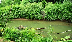
The Luckiamute River is a tributary of the Willamette River, about 61 miles (98 km) long, in western Oregon in the United States.[4] It drains an area of Central Oregon Coast Range and the western Willamette Valley northwest of Corvallis.[8]
It rises in the remote mountains of southwestern Polk County, about 10 miles (16 km) west of Pedee. It flows southeast to Hoskins in Benton County, then northeast into Polk County, past Pedee, then east across southern Polk County. It is joined from the northwest by the Little Luckiamute River. It joins the Willamette from the west about 10 miles (16 km) north of Albany. The mouth of the river is about 1⁄4 mile (400 m) downstream from the mouth of the Santiam River, which enters the Willamette from the east 108 miles (174 km) upstream of the Willamette's mouth on the Columbia River.[9]
Named tributaries from source to mouth are Boulder, Beaver, Miller, Wolf, Rock Pit, Slick, Cougar, Slide, and Harris creeks. Further downstream are Hull, Foster, Jones, Bonner, Vincent, Plunkett, and Price creeks. Maxfield Creek is next followed by Bump, Ritner, Pedee, McTimmonds, Link, Dry, and Jont creeks followed by the Little Luckiamute River. Soap Creek enters the main stem along the Luckiamute's lower reaches.[9]
The Luckiamute Watershed Council includes Ash Creek in its watershed study area, although it drains directly into the Willamette River.[5]
^ abc"Luckiamute River". Geographic Names Information System (GNIS). United States Geological Survey. November 28, 1980. Retrieved September 2, 2010.
^McArthur, Lewis A.; McArthur, Lewis L. (2003) [1928]. Oregon Geographic Names, 7th ed. Portland, Oregon: Oregon Historical Society Press. pp. 597–98. ISBN 0-87595-277-1.
^Source elevation derived from Google Earth search using GNIS source coordinates.
^ abPalmer, Tim (2014). Field Guide to Oregon Rivers. Corvallis: Oregon State University Press. pp. 176–77. ISBN 978-0-87071-627-0.
^ ab"Luckiamute Watershed". Luckiamute Watershed Council. Archived from the original on September 8, 2015. Retrieved October 4, 2015.
^"Water-Data Report 2010: 14190500 Luckiamute River near Suver, OR" (PDF). United States Geological Survey. Retrieved October 24, 2011.
^"Water-Data Report 2010: 14190500 Luckiamute River near Suver, OR" (PDF). United States Geological Survey. Retrieved October 24, 2011.
^Oregon Atlas & Gazetteer (1st ed.). Freeport, Maine: DeLorme Mapping. 1991. pp. 52–53. ISBN 0-89933-235-8.
^ ab"United States Topographic Map". United States Geological Survey. Retrieved March 4, 2016 – via Acme Mapper. The map includes mile markers along the Willamette and Luckiamute rivers.
The LuckiamuteRiver is a tributary of the Willamette River, about 61 miles (98 km) long, in western Oregon in the United States. It drains an area of...
The Little LuckiamuteRiver is a stream in Polk County in the U.S. state of Oregon. It rises in the Central Oregon Coast Range near Fanno Peak and joins...
Luckiamute may refer to: The Luckiamute band of the Kalapuya people of what is now the U.S. state of Oregon The LuckiamuteRiver, named for the Kalapuya...
Willamette Valley along the LuckiamuteRiver Chepenafa dialect, spoken in the central Willamette Valley along Marys River Chemapho dialect, spoken in...
Tualatin River Yamhill, along the Yamhill River -Central Kalapuya: Ahantchuyuk, along the Pudding RiverLuckiamute, along the LuckiamuteRiver Santiam...
McKenzie, Long Tom, Marys, Calapooia, Santiam, Luckiamute, Yamhill, Molalla, Tualatin, and Clackamas rivers. Beginning at 438 feet (134 m) above sea level...
Yaquina River Long Tom River Lookingglass Creek Lost River Lostine RiverLuckiamuteRiver Malheur River Marys River McKenzie River Metolius River Metolius...
Ritner Creek is a tributary of the LuckiamuteRiver in Polk County in the U.S. state of Oregon. The creek begins near Bald Mountain in the Central Oregon...
Calapooia, Santiam, Luckiamute, Yamhill, Molalla, Tualatin, and Clackamas rivers. Arising at 438 feet (134 m) above sea level, the river loses 428 feet (130 m)...
Geographers, Vol. 54, No. 3. (Sep. 1964), pp. 329–335. Geology of the LuckiamuteRiver Watershed, Upper Willamette Basin, Polk and Benton Counties, Oregon...
original on July 14, 2007. Retrieved March 27, 2018. Geology of the LuckiamuteRiver Watershed, Upper Willamette Basin, Polk and Benton Counties, Oregon...
Clark River Skipanon River Wallooskee River Youngs River Drains to Willamette River: Coast Fork Willamette River Long Tom RiverLuckiamuteRiver Marys...
"Luckiamute Watershed". Luckiamute Watershed Council. Archived from the original on September 8, 2015. Retrieved October 4, 2015. "LuckiamuteRiver"....
River Collawash River Tualatin River Fanno Creek Molalla River Pudding River Yamhill River North Yamhill River South Yamhill RiverLuckiamuteRiver Santiam...
Coast Range, the railroad followed the LuckiamuteRiver to connect Independence, a city along the Willamette River, to Valsetz, a logging community in the...
Oregon. The family farm was on a donation land claim located on the LuckiamuteRiver, and Waymire called his house Hayden Hall. In 1846, Waymire was elected...
County, Oregon, United States. It is located on the floodplain of the LuckiamuteRiver and is forested by Bigleaf Maple, Douglas-fir, and Black Cottonwood...
of Forestry. Retrieved 2008-04-03. Taylor, Stephen. "Geology of the LuckiamuteRiver Watershed, Upper Willamette Basin, Polk and Benton Counties, Oregon"...
Range". U.S. Geological Survey. Retrieved 2008-04-03. "Geology of the LuckiamuteRiver Watershed, Upper Willamette Basin, Polk and Benton Counties, Oregon"...
The Umpqua River Light is a lighthouse on the Oregon Coast of the United States, located at the mouth of the Umpqua River on Winchester Bay, in Douglas...
The Columbia River Gorge is a canyon of the Columbia River in the Pacific Northwest of the United States. Up to 4,000 feet (1,200 m) deep, the canyon...
The Historic Columbia River Highway is an approximately 75-mile-long (121 km) scenic highway in the U.S. state of Oregon between Troutdale and The Dalles...
archaeological values of the Hells Canyon area and the area of the Snake River between Hells Canyon Dam and the Oregon–Washington border. Roughly 215,000...
The Willamette River Greenway is a cooperative state and local government effort to maintain and enhance the scenic, recreational, historic, natural and...
 Global Information