 Global Information
Willamette River information
| Willamette River | |
|---|---|
 The Willamette passing through Downtown Portland in the 1980s | |
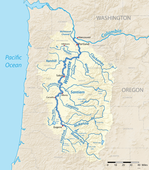 A map of the Willamette River, its drainage basin, major tributaries and major cities | |
| Etymology | From a Clackamas Native American village name[1] |
| Location | |
| Country | United States |
| State | Oregon |
| Cities | Eugene, Corvallis, Albany, Independence, Salem, Newberg, Wilsonville, Portland |
| Physical characteristics | |
| Source | Confluence of Middle Fork Willamette River and Coast Fork Willamette River |
| • location | near Eugene, Lane County, Oregon |
| • coordinates | 44°01′23″N 123°01′25″W / 44.02306°N 123.02361°W[2] |
| • elevation | 438 ft (134 m)[2] |
| Mouth | Columbia River |
• location | Portland, Multnomah County, Oregon |
• coordinates | 45°39′10″N 122°45′53″W / 45.65278°N 122.76472°W[2] |
• elevation | 10 ft (3.0 m)[2] |
| Length | 187 mi (301 km)[3] |
| Basin size | 11,478 sq mi (29,730 km2)[4] |
| Discharge | |
| • location | Morrison Bridge, Portland, 12.8 miles (20.6 km) from mouth |
| • average | 33,010 cu ft/s (935 m3/s) |
| • minimum | 4,200 cu ft/s (120 m3/s) |
| • maximum | 420,000 cu ft/s (12,000 m3/s) |
| Basin features | |
| Tributaries | |
| • left | Coast Fork Willamette River, Long Tom River, Marys River, Luckiamute River, Yamhill River, Tualatin River |
| • right | Middle Fork Willamette River, McKenzie River, Calapooia River, Santiam River, Molalla River, Clackamas River |
The Willamette River (/wɪˈlæmɪt/ ⓘ wil-AM-it) is a major tributary of the Columbia River, accounting for 12 to 15 percent of the Columbia's flow. The Willamette's main stem is 187 miles (301 km) long, lying entirely in northwestern Oregon in the United States. Flowing northward between the Oregon Coast Range and the Cascade Range, the river and its tributaries form the Willamette Valley, a basin that contains two-thirds of Oregon's population, including the state capital, Salem, and the state's largest city, Portland, which surrounds the Willamette's mouth at the Columbia.
Originally created by plate tectonics about 35 million years ago and subsequently altered by volcanism and erosion, the river's drainage basin was significantly modified by the Missoula Floods at the end of the most recent ice age. Humans began living in the watershed over 10,000 years ago. There were once many tribal villages along the lower river and in the area around its mouth on the Columbia. Indigenous peoples lived throughout the upper reaches of the basin as well.
Rich with sediments deposited by flooding and fed by prolific rainfall on the western side of the Cascades, the Willamette Valley is one of the most fertile agricultural regions in North America, and it was thus the destination of many 19th-century pioneers traveling west along the Oregon Trail. The river was an important transportation route in the 19th century, although Willamette Falls, just upstream from Portland, was a major barrier to boat traffic. In the 21st century, major highways follow the river, and roads cross the main stem on approximately 30 different bridges. More than half a dozen bridges not open to motorized vehicles provide separate crossings for bicycles and pedestrians, mostly in the Eugene area, and several others are exclusively for rail traffic. There are also ferries that convey cars, trucks, motorcycles, bicycles, and pedestrians across the river for a fare and provided river conditions permit. They are the Buena Vista Ferry between Marion County and Polk County south of Independence and Salem, the Wheatland Ferry between Marion County and Polk County north of Salem and Keizer, and Canby Ferry in Clackamas County north of Canby.
Since 1900, more than 15 large dams and many smaller ones have been built in the Willamette's drainage basin, 13 of which are operated by the U.S. Army Corps of Engineers (USACE). The dams are used primarily to produce hydroelectricity, to maintain reservoirs for recreation, and to prevent flooding. The river and its tributaries support 60 fish species, including many species of salmon and trout; this is despite the dams, other alterations, and pollution (especially on the river's lower reaches). Part of the Willamette Floodplain was established as a National Natural Landmark in 1987, and the river was named as one of 14 American Heritage Rivers in 1998.
- ^ Cite error: The named reference
Brightwas invoked but never defined (see the help page). - ^ a b c d Cite error: The named reference
gniswas invoked but never defined (see the help page). - ^ "Facts About the Willamette River". Willamette Riverkeeper. Archived from the original on October 31, 2016. Retrieved November 16, 2016.
- ^ Robbins, William G. "Willamette River". The Oregon Encyclopedia. Portland State University and the Oregon Historical Society. Retrieved May 19, 2014.