Global Information Lookup Global Information

Course of the Willamette River information


Willamette
Oregon City Bridge and Willamette Falls
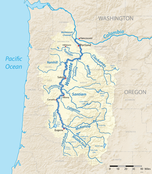
A map of the Willamette River, its drainage basin, major tributaries and major cities
Course of the Willamette River is located in Oregon
Course of the Willamette River
Location of the mouth of the Willamette River in Oregon
EtymologyFrom a Clackamas Indian village name[2]
Location
CountryUnited States
StateOregon
Physical characteristics
SourceConfluence of Middle Fork Willamette River and Coast Fork Willamette River
 • locationnear Eugene, Lane County, Oregon
 • coordinates44°01′23″N 123°01′25″W / 44.02306°N 123.02361°W / 44.02306; -123.02361[1]
 • elevation438 ft (134 m)[1]
MouthColumbia River
 • location
Portland, Multnomah County, Oregon
 • coordinates
45°39′10″N 122°45′53″W / 45.65278°N 122.76472°W / 45.65278; -122.76472[1]
 • elevation
10 ft (3.0 m)[1]
Length187 mi (301 km)[3]
Basin size11,100 sq mi (29,000 km2)[4]
Discharge 
 • locationMorrison Bridge, Portland, 12.8 miles (20.6 km) from mouth[5]
 • average33,800 cu ft/s (960 m3/s)[5]

The Willamette River is a 187-mile (301 km) tributary of the Columbia River in the U.S. state of Oregon. The upper tributaries of the Willamette originate in mountains south and southeast of the twin cities of Eugene and Springfield. Formed by the confluence of the Middle Fork Willamette River and Coast Fork Willamette River near Springfield, the main stem meanders generally north from source to mouth. The river's two most significant course deviations occur at Newberg, where the stream turns sharply east, and about 18 miles (29 km) downriver from Newberg, where it turns north again. Near its mouth, the river splits into two channels that flow around Sauvie Island. The main channel enters the Columbia about 101 miles (163 km) from the larger stream's mouth on the Pacific Ocean, and the smaller Multnomah Channel enters the Columbia about 14.5 miles (23.3 km) further downstream near St. Helens in Columbia County.

Incorporated Cities along the Willamette's course include Springfield and Eugene in Lane County; Harrisburg in Linn County; Corvallis in Benton County; Albany in Linn and Benton counties; Independence in Polk County; Salem in Marion and Polk Counties; Keizer in Marion County; Newberg in Yamhill County; Oregon City, West Linn, Milwaukie, and Lake Oswego in Clackamas County (Small portions of the later two extend into Multnomah County), and Portland in Multnomah County. (Parts of Portland are also in Washington County, but the Willamette never makes contact with Washington County.) Significant tributaries include the McKenzie, Long Tom, Marys, Calapooia, Santiam, Luckiamute, Yamhill, Molalla, Tualatin, and Clackamas rivers.

Arising at 438 feet (134 m) above sea level, the river loses 428 feet (130 m) in elevation between source and mouth or about 2.3 feet per mile (43 cm per km). The gradient is slightly steeper from the source to Albany than from Albany to Oregon City. At Willamette Falls, the river plunges about 40 feet (12 m). For the rest of its course, the river is extremely low-gradient and is influenced by Pacific Ocean tidal effects from the Columbia. The main stem of the Willamette varies in width from about 330 to 660 feet (100 to 200 m).

  1. ^ a b c d Cite error: The named reference gnis was invoked but never defined (see the help page).
  2. ^ Bright, p. 567
  3. ^ "The River". Willamette Riverkeeper. Archived from the original on October 8, 2006. Retrieved June 26, 2010.
  4. ^ "National Water Information System: USGS 14211720 Willamette River at Portland". United States Geological Survey. 2008. Retrieved June 26, 2010.
  5. ^ a b Loy, et al., pp. 164–65

and 21 Related for: Course of the Willamette River information

Request time (Page generated in 0.8245 seconds.)

Course of the Willamette River

Last Update:

The Willamette River is a 187-mile (301 km) tributary of the Columbia River in the U.S. state of Oregon. The upper tributaries of the Willamette originate...

Word Count : 5128

Willamette River

Last Update:

The Willamette River (/wɪˈlæmɪt/ wil-AM-it) is a major tributary of the Columbia River, accounting for 12 to 15 percent of the Columbia's flow. The Willamette's...

Word Count : 10822

List of crossings of the Willamette River

Last Update:

023318; -123.023897 (Willamette River source), is considered the source of the Willamette River. Course of the Willamette River List of bridges in Portland...

Word Count : 255

Coast Fork Willamette River

Last Update:

The Coast Fork Willamette River is one of two forks that unite to form the Willamette River in western Oregon in the United States. It is about 40 miles...

Word Count : 287

Santiam River

Last Update:

The Santiam River /ˌsæntiːˈæm/ is a tributary of the Willamette River, about 12 miles (19 km) long, in western Oregon in the United States. Through its...

Word Count : 556

Little Willamette River

Last Update:

The Little Willamette River is a minor tributary of the Willamette River in Linn County in the U.S. state of Oregon. It begins in a gravel pit slightly...

Word Count : 232

Tualatin River

Last Update:

The Tualatin River is a tributary of the Willamette River in Oregon in the United States. The river is about 83 miles (134 km) long, and it drains a fertile...

Word Count : 1962

Pudding River

Last Update:

evidence of the Willamette River's confluence with the Pudding River mainstem channel. Currently, it flows directly into the Molalla River near River Mile...

Word Count : 874

Willamette Stone

Last Update:

of downtown Portland. The site is near Skyline Boulevard, in the West Hills overlooking the Tualatin Valley and the Willamette River watershed. The grid...

Word Count : 1184

Middle Fork Willamette River

Last Update:

The Middle Fork Willamette River is one of several forks that unite to form the Willamette River in the western part of the U.S. state of Oregon. It is...

Word Count : 507

Oregon Route 58

Last Update:

between the cities of Eugene and Creswell. It heads due southeast from there, following the course of the Willamette River into the foothills of the Cascade...

Word Count : 1184

Molalla River

Last Update:

The Molalla River is a 51-mile (82 km) tributary of the Willamette River in the northwestern part of Oregon in the United States. Flowing northwest from...

Word Count : 1383

Clackamas River

Last Update:

The Clackamas River is an approximately 83-mile (134 km) tributary of the Willamette River in northwestern Oregon, in the United States. Draining an area...

Word Count : 2318

Yamhill River

Last Update:

The Yamhill River is an 11-mile (18 km) tributary of the Willamette River, in the U.S. state of Oregon. Formed by the confluence of the South Yamhill...

Word Count : 469

Willamette Mission State Park

Last Update:

damaged, and the Willamette River changed its course. The mission site is listed on the National Register of Historic Places as the "Willamette Station Site...

Word Count : 540

Columbia River

Last Update:

used the Columbia as a key transportation route. Overland explorers entered the Willamette Valley through the scenic, but treacherous Columbia River Gorge...

Word Count : 18448

Columbia Slough

Last Update:

its source in the Portland suburb of Fairview, the Columbia Slough meanders west through Gresham and Portland to the Willamette River, about 1 mile (1...

Word Count : 9110

Willamette University

Last Update:

Willamette University is a private liberal arts college with locations in Salem and Portland, Oregon. Founded in 1842, it is the oldest college in the...

Word Count : 4912

South Yamhill River

Last Update:

drains an area of the Northern Oregon Coast Range, as well as part of the Willamette Valley west of the Willamette River. The South Yamhill River rises at an...

Word Count : 944

Breitenbush River

Last Update:

through the Willamette National Forest. It joins the North Santiam at Detroit. The lower 2 miles (3.2 km) of the river cut what is now an arm of Detroit...

Word Count : 323

North Yamhill River

Last Update:

part of the Willamette Valley west of the Willamette River. Rising in a remote area in the mountains of northwestern Yamhill County, the river flows...

Word Count : 708

PDF Search Engine © AllGlobal.net