Canyon along the border of Oregon and Washington in the United States
"Columbia Gorge" redirects here. For the Washington-Oregon wine region, see Columbia Gorge AVA. For the riverboat, see Columbia Gorge (sternwheeler).
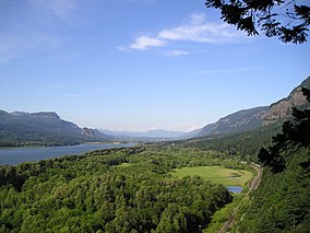
Columbia River Gorge
Looking east up the Columbia River Gorge from near Multnomah Falls.
Location
Pacific Northwest, United States
Established
1986
Website
www.fs.usda.gov/crgnsa
The Columbia River Gorge is a canyon of the Columbia River in the Pacific Northwest of the United States. Up to 4,000 feet (1,200 m) deep, the canyon stretches for over eighty miles (130 km) as the river winds westward through the Cascade Range, forming the boundary between the state of Washington to the north and Oregon to the south.[1] Extending roughly from the confluence of the Columbia with the Deschutes River (and the towns of Roosevelt, Washington, and Arlington, Oregon) in the east down to the eastern reaches of the Portland metropolitan area, the water gap furnishes the only navigable route through the Cascades and the only water connection between the Columbia Plateau and the Pacific Ocean. It is thus that the routes of Interstate 84, U.S. Route 30, Washington State Route 14, and railroad tracks on both sides run through the gorge.
A popular recreational destination, the gorge holds federally protected status as the Columbia River Gorge National Scenic Area and is managed by the Columbia River Gorge Commission and the U.S. Forest Service.
^Staats, David (November 21, 1983). "The Gorge". Spokane Chronicle. (Washington). Associated Press. p. A15.
and 20 Related for: Columbia River Gorge information
The ColumbiaRiverGorge is a canyon of the ColumbiaRiver in the Pacific Northwest of the United States. Up to 4,000 feet (1,200 m) deep, the canyon stretches...
the Columbia as a key transportation route. Overland explorers entered the Willamette Valley through the scenic, but treacherous ColumbiaRiverGorge, and...
miles (210 km) west of Spokane. This venue offers views of the ColumbiaRiver, ColumbiaGorge canyon, eastern Kittitas, and western Grant County.[citation...
ColumbiaGorge is an American Viticultural Area (AVA) which includes land surrounding the ColumbiaRiverGorge, straddling the border between Oregon and...
coordinates) GPX (secondary coordinates) Oneonta Gorge is a scenic gorge located in the ColumbiaRiverGorge area of the American state of Oregon. The U.S...
state of Oregon between Troutdale and The Dalles, built through the ColumbiaRiverGorge between 1913 and 1922. As the first planned scenic roadway in the...
spelling: cañon), gorge or chasm, is a deep cleft between escarpments or cliffs resulting from weathering and the erosive activity of a river over geologic...
The Eagle Creek Fire was a destructive wildfire in the ColumbiaRiverGorge, largely in the U.S. state of Oregon, with smaller spot-fires in Washington...
protecting the ColumbiaRiverGorge as a National Scenic Area in 1986. She was "a backpacking and wildflower enthusiast who loved the ColumbiaGorge and other...
the ColumbiaRiverGorge, east of Troutdale, between Corbett and Dodson, Oregon, United States. The waterfall is accessible from the Historic Columbia River...
ColumbiaRiverGorge at the end of the last ice age. These floods were the result of periodic sudden ruptures of the ice dam on the Clark Fork River that...
(Washington) since 2002. It is adjacent to the ColumbiaRiver, near the east end of the ColumbiaRiverGorge National Scenic Area. The airport, originally...
cataclysmic floods that swept across eastern Washington and down the ColumbiaRiverGorge approximately 40 times during a 2,000 year period. The cumulative...
continues into the ColumbiaRiverGorge National Scenic Area. It passes through the cities of Hood River and The Dalles within the gorge and also serves...
ColumbiaGorge Community College is a public community college in The Dalles, Oregon, which is situated and surrounded by the ColumbiaGorge National Scenic...
The ColumbiaGorge Orchestra Association (CGOA) is a nonprofit organization that sponsors several performing ensembles in the ColumbiaRiverGorge area...
includes the Steens and Picture Gorge basalt formations. During the middle to late Miocene epoch, the ColumbiaRiver flood basalts engulfed about 163...
tribes in the U.S. state of Oregon) sought to build a casino in the ColumbiaRiverGorge. They ended their pursuit of the project in 2013. They considered...
The Deschutes River (/dəˈʃuːts/ də-SHOOTS) in central Oregon is a major tributary of the ColumbiaRiver. The river provides much of the drainage on the...
Oregon, United States, disappeared on December 7, 1958, in the ColumbiaRiverGorge during a day trip to gather greenery for Christmas decorations. The...
 Global Information