This article uses bare URLs, which are uninformative and vulnerable to link rot. Please consider converting them to full citations to ensure the article remains verifiable and maintains a consistent citation style. Several templates and tools are available to assist in formatting, such as reFill (documentation) and Citation bot (documentation).(September 2022) (Learn how and when to remove this message)
River
Hotan River
The Hotan River is formed by the union of the White Jade and Black Jade Rivers in northern China.[1]
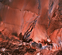
The Hotan River (also known as the Khotan River or the Ho-t'ien River) is formed by the union of the White Jade (Yurungkash) and Karakash (Black Jade) Rivers, which flow north from the Kunlun Mountains into the Taklamakan Desert in northern China. The two rivers unite towards the middle of the desert, some 145 kilometres (90 mi) north of the town of Hotan. The river then flows 290 kilometres (180 mi) northwards across the desert and empties itself into the Tarim River.[2] Because the river is fed by melting snow from the mountains, it only carries water during the summer and is dry the rest of the year. Prior to construction of the Tarim Desert Highway in 1995, the Hotan river bed provided the only transportation system across the Tarim Basin.[3]
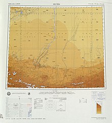
Map including the Hotan River (labeled as Ho-tien Ho) and surrounding region (USATC, 1971)[a]
^The Southwest Taklimakan Desert Archived 2014-04-07 at the Wayback Machine from NASA's Geomorphology from Space Archived 2006-09-29 at the Wayback Machine. Retrieved March 29, 2014.
Cite error: There are <ref group=lower-alpha> tags or {{efn}} templates on this page, but the references will not show without a {{reflist|group=lower-alpha}} template or {{notelist}} template (see the help page).
The HotanRiver (also known as the Khotan River or the Ho-t'ien River) is formed by the union of the White Jade (Yurungkash) and Karakash (Black Jade)...
proper of Hotan broke off from the larger Hotan County to become an administrative area in its own right in August 1984. It is the seat of Hotan Prefecture...
of Khotan (Hotan) to flow northeast in the Tarim Basin. It merges with the Yurungkash River, the combined river taking the name HotanRiver and flowing...
Its main tributaries include the HotanRiver, the Aksu River, and the Kashgar River. The course of the Tarim River swings from north to south in history...
Hotan County (also known as Gosthana, Gaustana, Godana, Godaniya, Khotan, Hetian, Hotien) is a county in the southwest of the Xinjiang Uyghur Autonomous...
(June, 2013) Digging for jade under the G315 Highway bridge over the HotanRiver Yarkand on G315 Highway, Xinjiang Yarkand on G315 Highway, Xinjiang A...
08; 80.56), from where it continues north as the HotanRiver, which flows into the Tarim River. The river drains an area of 14,575 km2 (5,627 sq mi) and...
fields occur in the Lut Desert of Iran, Arabian Desert of Kuwait, the HotanRiver Basin in Xinjiang, China, and New Mexico in the United States and adjacent...
Most dry up in the desert; only the HotanRiver reaches the Tarim in good years. An exception is the Qiemo River which flows northeast into Lop Nor. Ruins...
which has been isolated from the Populus euphratica forest from the HotanRiver valley in China. Parte, A.C. "Sphingobacterium". LPSN. "Sphingobacterium...
Aksai Chin is a region administered by China partly in Hotan County, Hotan Prefecture, Xinjiang and partly in Rutog County, Ngari Prefecture, Tibet and...
Uyghur: لوپ ناھىيىسى), also Luopu (from Mandarin Chinese), is a county in Hotan Prefecture, in the southwest of the Xinjiang Uyghur Autonomous Region, China...
The Kunlun Mountains are a mountain range on the upper reaches of the HotanRiver in Xinjiang Province, Northwestern China. According to Chinese folklore...
Eastern Han period (25–220 AD) Large "mutton fat" nephrite jade displayed in Hotan Cultural Museum lobby. A selection of antique, hand-crafted Chinese jade...
considerable rainfall and snow. Rivers drain into the basin from the mountains, including the northward-flowing HotanRiver, which drains the western Kunlun...
follow the HotanRiver from Hotan downstream into the Tarim Basin, and the Yarkand River. At the confluence, they went along the Tarim River to the eastern...
pebbles and boulders in the rivers flowing from the Kuen-Lun mountain range northward into the Takla-Makan desert area. River jade collection was concentrated...
original on 19 March 2012. Retrieved 1 February 2016. "Construction of Hotan-Ruoqiang Railway Underway in China's Xinjiang". 2020-12-02. "Mumbai Trans...
in the book called Tevarih-i Muskiyun, which was written in 1867 in the Hotan Prefecture of Xinjiang. In folk etymology, it is said to mean "Place of...
Tarim basin (Taklamakan Desert). The Karakax river separates the county from Hotan County and the HotanRiver separates the county from Lop County. The length...
kilometers south of the Tarim River. The only major settlement along the river is Keriya Town, east of Hotan. The river is an important source of irrigation...
mined at the lake to the Lanzhou–Xinjiang railway. It is also served by the Hotan–Ruoqiang railway, which loops around the south and west side of the Tarim...
which means "encounter with a round object". The lake is part of Hotan County, Hotan Prefecture, Xinjiang, The lake is located just south of the Kunlun...
to the city of Hotan (formerly Khotan or Ilchi; see adjacent maps). G580 is under construction connecting Kangxiwar directly with Hotan. It will tunnel...
has focused construction on State Road 314, Alar-Hotan Desert Highway, State Road 218, Qingshui River Line-Yining Highway and State Road 217, as well as...
 Global Information