You can help expand this article with text translated from the corresponding article in Uyghur. (December 2019) Click [show] for important translation instructions.
Do not translate text that appears unreliable or low-quality. If possible, verify the text with references provided in the foreign-language article.
You must provide copyright attribution in the edit summary accompanying your translation by providing an interlanguage link to the source of your translation. A model attribution edit summary is Content in this edit is translated from the existing Uyghur Wikipedia article at [[:ug:لوپ ناھىيىسى]]; see its history for attribution.
You may also add the template {{Translated|ug|لوپ ناھىيىسى}} to the talk page.
For more guidance, see Wikipedia:Translation.
County in Xinjiang, China
Lop County
لوپ ناھىيىسى(Uyghur) 洛浦县(Chinese)
Luopu, Lo-p'u
County
Rawak Stupa in the Taklamakan Desert
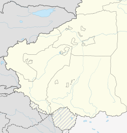
Location of Lop County (red) within Hotan Prefecture (yellow) and Xinjiang
Lop County[6][7][8][9][10] (pronunciationⓘ,[11] Uyghur: لوپ ناھىيىسى), also Luopu[12][13] (from Mandarin Chinese), is a county in Hotan Prefecture, in the southwest of the Xinjiang Uyghur Autonomous Region, China. Almost all the residents of the county are Uyghur and live around oases situated between the desolate Taklamakan Desert and Kunlun Mountains. The county is bordered to the north by Aksu and Awat County in Aksu Prefecture,[1] to the east by Qira/Chira County, to the northwest by Karakax County, to the west by Hotan (Khotan) and to the south and west by Hotan County.
^ ab政府概况. Luopu County Government Network 洛浦县政府网 (in Simplified Chinese). Retrieved 18 December 2019. 西以玉龙喀什河为界与和田县、和田市隔河相望,北伸延入塔克拉玛干大沙漠与阿克苏市、阿瓦提县为邻{...}总面积14287平方公里。{...}境内山丘属昆仑支脉,南部最高山为铁克勒克山,海拔5466米。
^ abCite error: The named reference xzqhlop was invoked but never defined (see the help page).
^Cite error: The named reference cihai was invoked but never defined (see the help page).
^Xinjiang: Prefectures, Cities, Districts and Counties
^Cite error: The named reference guardian was invoked but never defined (see the help page).
^Cite error: The named reference usdhs was invoked but never defined (see the help page).
^Lop (Approved - N) at GEOnet Names Server, United States National Geospatial-Intelligence Agency
^Complete Atlas Of The World (3 ed.). Penguin Random House. 2016. p. 238. ISBN 978-1-4654-4401-1 – via Internet Archive. Lop
^Che Muqi [in Chinese] (1989). The Silk Road, Past and Present. Beijing: Foreign Languages Press. p. 286. ISBN 0-8351-2100-3 – via Internet Archive. Today in Hotan Prefecture, including Pishan, Moyu, Lop, Qira, Yutian and Minfeng counties–places under the jurisdiction of ancient Khotan State which once dominated the southern route of the Silk Road–818 cobbled canals with a combined length of 1,500 kilometres have been built.
^Jianghua Zhang; Xianhui Zhou; Qiang Xing; Yaodong Li; Ling Zhang; Qina Zhou; Yanmei Lu; Yinwen Fan; Abu Lizi; Wenhong Yan; Hongyan Wang; Meiling Zhai; Jianfu Bao; Liping Chen; Maihe Tuoti; Haidong Cui; Jian Wang; Baopeng Tang (28 January 2019). "Epidemiological investigation of sudden cardiac death in multiethnic Xinjiang Uyghur autonomous region in Northwest China". BMC Public Health. 19 (1): 116. doi:10.1186/s12889-019-6435-8. PMC 6348672. PMID 30691418. Thus, 11 survey sites were finally selected, as follows: the Saybagh District of Ürümqi city; in Ili Prefecture, Yining city and Xinyuan County; within Bayingolin Prefecture, Korla city and Yanqi County; in Hami Prefecture, Hami city and Barkol County; within the Hotan Prefecture, Hotan city and Lop County; and of the Bingtuan, the cities of Aral and Wujiaqu.
^Lop. Columbia Lippincott Gazetteer of the World. Morningside Heights, New York, Columbia University Press, by arrangement with J.B. Lippincott Co. 1952. p. 1081 – via Internet Archive. Lop (lōp)
^"洛浦县政府网 Luopu County Government Network" (in Simplified Chinese and English). Retrieved 18 December 2019.
^Luopu (Approved - N) at GEOnet Names Server, United States National Geospatial-Intelligence Agency
Cite error: There are <ref group=lower-alpha> tags or {{efn}} templates on this page, but the references will not show without a {{reflist|group=lower-alpha}} template or {{notelist}} template (see the help page).
LopCounty (pronunciation, Uyghur: لوپ ناھىيىسى), also Luopu (from Mandarin Chinese), is a county in Hotan Prefecture, in the southwest of the Xinjiang...
Lop or lop in Wiktionary, the free dictionary. Lop may refer to: LopCounty, county in Hotan, Xinjiang, China Lop language, a language spoken in Lop County...
The Holland Lop is a breed of lop-eared rabbit that was recognized by the American Rabbit Breeders Association (ARBA) in 1979. The Holland Lop, with a maximum...
Lop Nur or Lop Nor (from a Mongolian name meaning "Lop Lake", where "Lop" is a toponym of unknown origin) is a now largely dried-up salt lake formerly...
Aksu Prefecture Eight vocational training centres in LopCounty (Luopu), Hotan Prefecture LopCounty No. 4 Vocational Skills Education and Training Center...
made with labor from the LopCounty No. 4 Vocational Skills Education and Training Center; hair products made in the LopCounty Hair Product Industrial...
Left image: The Sampul tapestry, a woolen wall hanging from LopCounty, Hotan Prefecture, Xinjiang, China, possibly showing a Yuezhi, wielding a spear...
The Miniature Lion Lop is a breed of domestic rabbit recognised by the British Rabbit Council. The breed is not currently recognized by the American Rabbit...
woolen wall-hanging found at the Tarim Basin settlement of Sampul in LopCounty, Hotan Prefecture, Xinjiang, China, close to the ancient city of Khotan...
county-level division of Xinjiang. The county borders Karakax/Moyu County to the northwest, Hotan City and LopCounty to the northeast, Qira County to...
Uyghurs. The county is bordered to the north by Awat County in Aksu Prefecture, to the northeast by LopCounty, to the southeast by Hotan County, to the northwest...
At the cemetery in Sampul (Shanpula; 山普拉), ~14 km from Khotan (now in LopCounty, Hotan Prefecture, Xinjiang), where the aforementioned Sampul tapestry...
Chinese: 山普鲁镇; traditional Chinese: 山普魯鎮, formerly 山普鲁乡 / 山普魯鄉) is a town in LopCounty (Luopu), Hotan Prefecture, Xinjiang, China. Local inhabitants at Sampul...
toward Charkilik, and Loulan was abandoned. The Tarim ended at the now-dry Lop Nur, which occupied a shifting position east of Loulan. Eastward is the fabled...
Prefecture, to the east by Yutian / Keriya County, to the northwest by LopCounty, to the southwest by Hotan County including the China-India disputed Aksai...
British Lop is a traditional British breed of pig from the West Country of south-western England. It is a large, white-skinned pig with lop ears hanging...
Sampul (Chinese: 山普拉), ~14 km from the archaeological site of Khotan in LopCounty, where Hellenistic art such as the Sampul tapestry has been found (its...
with "LOP 1" in County Louth and continuing in a clockwise direction around the coast finishing with "LOP 82" at Inishowen in County Donegal. LOP 83 is...
from Delos, c. 100 BC The Sampul tapestry, a woollen wall hanging from LopCounty, Hotan Prefecture, Xinjiang, China, showing a possibly Greek soldier from...
of intent, Fu Huacheng, a passenger and the minister of education for LopCounty, recalled running out of his seat and shouting in Uyghur to his fellow...
This is a list of all counties (including autonomous counties, autonomous banners, and banners) along with county-level cities (Chinese: 县级市; pinyin:...
Hotan County, and from then on governed as a county-level city. On July 11, 2006, the townships of Jiya and Yurungqash (Yulongkashi) in LopCounty and Tusalla...
shield, 3rd century BC The Sampul tapestry, a woollen wall hanging from LopCounty, Hotan Prefecture, Xinjiang, China, showing a possibly Greek soldier from...
desert along the 39°28′57″N parallel that divides it from LopCounty (Luopu) and Qira County (Cele) in Hotan Prefecture (Hetian). The kingdom bordered...
 Global Information