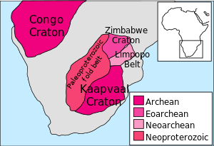
Map of the Zimbabwe and Kaapvaal CratonsSW end of the 550 km long Great Dyke of Zimbabwe from ISS, 2010.Brachiosaurus femur and Geologist Metrinah Ruzvidzo, 2005
The geology of Zimbabwe in southern Africa is centered on the Zimbabwe Craton, a core of Archean basement composed in the main of granitoids, schist and gneisses. It also incorporates greenstone belts comprising mafic, ultramafic and felsic volcanics which are associated with epiclastic sediments and iron formations. The craton is overlain in the north, northwest and east by Proterozoic and Phanerozoic sedimentary basins whilst to the northwest are the rocks of the Magondi Supergroup.[1] Northwards is the Zambezi Belt and to the east the Mozambique Belt. South of the Zimbabwe Craton is the Kaapvaal Craton separated from it by the Limpopo Mobile Belt, a zone of deformation and metamorphism reflecting geological events from Archean to Mesoproterozoic times. The Zimbabwe Craton is intruded by an elongate ultramafic/mafic igneous complex known as the Great Dyke which runs for more than 500 km along a SSW/NNE oriented graben. It consists of peridotites, pyroxenites, norites and bands of chromitite.[2]
^Treloar, Peter J. (1988). "The geological evolution of the Magondi Mobile Belt, Zimbabwe". Precambrian Research. 38 (1): 55–73. Bibcode:1988PreR...38...55T. doi:10.1016/0301-9268(88)90093-9.
^"Zimbabwe, geology Extractive Industries Source Book". Archived from the original on 2013-03-02. Retrieved 2013-04-20.
and 29 Related for: Geology of Zimbabwe information
The geologyofZimbabwe in southern Africa is centered on the Zimbabwe Craton, a core of Archean basement composed in the main of granitoids, schist and...
Zimbabwe (/zɪmˈbɑːbweɪ, -wi/; Shona pronunciation: [zi.ᵐba.ɓwe]), officially the Republic ofZimbabwe, is a landlocked country in Southern Africa, between...
The ZimbabweGeological Survey, founded in 1910, is Zimbabwe's premier geological research organization. The survey is overseen by the Zimbabwe's Ministry...
stable part of the continental lithosphere, that occupies large portions of South Africa, Botswana, Namibia and Zimbabwe. It consists of two cratons separated...
Belt of granulite facies tectonites. The Limpopo belt formed contemporaneously with the Zimbabwe and Kaapvaal cratons, but remained geologically active...
linear geological feature that trends nearly north-south through the centre ofZimbabwe passing just to the west of the capital, Harare. It consists of a band...
Zimbabwe is a landlocked country in southern Africa lying north of the Tropic of Capricorn. During summer, the whole country experiences warm temperatures...
of Zimbabwe Climate ofZimbabwe Ecoregions in Zimbabwe Renewable energy in ZimbabweGeologyofZimbabwe Protected areas ofZimbabwe National parks of Zimbabwe...
The University ofZimbabwe (UZ) is a public university in Harare, Zimbabwe. It opened in 1952 as the University College of Rhodesia and Nyasaland, and...
South Africa List of fossiliferous stratigraphic units in Zambia GeologyofZimbabwe Gokwe Formation at Fossilworks.org Kadsi Formation at Fossilworks...
library are geological maps for Zimbabwe as well as photographs. Natural History Museum ofZimbabwe Website "Geology and Paleontology in Zimbabwe". 18 November...
Leone, and Togo) Zaire Craton (Congo) Zimbabwe Craton – Area in Southern Africa of ancient continental crust (Zimbabwe) Bellingshausen Plate – Ancient tectonic...
South Africa and Zimbabwe, runs E-NE, and joins the Kaapvaal Craton to the south with the Zimbabwe Craton to the north. The belt is of high-grade metamorphic...
species of plants and animals. It is located on the border between Zambia and Zimbabwe and is one of the world's largest waterfalls, with a width of 1,708 m...
Killarney, Bulawayo. Zimbabwe School of mines mainly offers qualification in National Diploma and Higher National Diploma in Mining, Mine Geology, Mine Survey...
formations List of stratigraphic units with indeterminate dinosaur fossils List of fossiliferous stratigraphic units in ZimbabweGeologyofZimbabwe Molteno Formation...
Reserve) is the largest natural reserve in Zimbabwe. It is around 14,600 sq km in area. It lies in the northwest of the country, just off the main road between...
Mana Pools Great Zimbabwe Khami Victoria Falls Matobo Hills The United Nations Educational, Scientific and Cultural Organization (UNESCO) World Heritage...
Geological Survey of Sweden Geological Survey of Norway Geological Survey of Finland Mexican Geological Survey ZimbabweGeological Survey Bureau de Recherches...
The geologyof Nigeria formed beginning in the Archean and Proterozoic eons of the Precambrian. The country forms the Nigerian Province and more than half...
north ofZimbabwe's Eastern Highlands. One of the first national parks to be declared in the country, it contains the highest land in Zimbabwe, with green...
The geologyof Mozambique is primarily extremely old Precambrian metamorphic and igneous crystalline basement rock, formed in the Archean and Proterozoic...
also found in Namibia, Eswatini, Zambia, Zimbabwe and Malawi, as well as on other continents that were part of Gondwana. The basins in which it was deposited...
extraction of sand and gravel for building material. Geologyof the Canary Islands Geologyof Cape Verde Wikimedia Commons has media related to Geologyof Madeira...
The Batoka Formation is a geological formation in the Zambezi valley in Botswana, Zambia and Zimbabwe. It is predominantly a volcanic unit comprising...
Geological engineering is a discipline of engineering concerned with the application ofgeological science and engineering principles to fields, such as...
The geologyof Botswana plays a significant part in the country's economy. The basement rocks of the Kaapvaal-Zimbabwe craton extend into Botswana whilst...
1902-1989 Love, D. (February 2002). "The geologyof Nyangani Mountain: a preliminary report" (PDF). University ofZimbabwe Earth Science Research Seminar Series...
Bushveld igneous complex of South Africa, the Great Dyke in Zimbabwe, the Skaergaard complex of Greenland and the Humboldt lopolith of Nevada. The Sudbury...
 Global Information